Friday March 1 2019
When I said that March was coming in like a lion, some people took issue with me. We had an average of 2 inches of snow across our region this morning. Even though it delayed most area schools, it was not a major event. But we have another one tonight, and yet another one on Sunday that could be the largest of the bunch. So perhaps its better to say, March is coming in like a litter of cubs.
Winter Weather Advisory
This Winter Weather Advisory includes the colder northern and western counties from Baltimore:
- Northern Harford, Baltimore, Carroll, Frederick, Washington, Allegany).
- Snow and freezing rain will arrive this evening around 7 PM. Plus or minus an hour depending on your location.
- The expectation is for maybe a little snow and up to 2 tenths of an inch of ice.
Baltimore and southward this should be just a chilly rain.
Southern Pennsylvania JUST ADDED TO THE ADVISORY. Click here to see the updated report .
This region can get 1 to 3 inches of snow where it remains all snow. Otherwise, it will be a mix of some snow and ice on top. See the two radar simulation timelines below that support it.

Was Your County Not Included?
Click this map for more on the regional forecast zones.
The Set Up
The track has been laid down for a few systems to ride along. The next one is coming up from the south. It looks like rain, but it will catch up to air that is just barely cold enough inland to turn to freezing rain or snow. Considering that we have snow on the ground, this will help to chill the air this evening when it arrives.

Radar Simulation Timelines
The Winter Weather Advisory begins at 7 PM and most of the area will get in on the action around that time or within an hour or so.
This should end before sunrise… But there may be a light glaze of ice or minor snow to clean up.
HRRR Model —> slider
[metaslider id=74219]
Temperatures at Midnight
The cold advisory areas will be within a degree or two of freezing.

NAM Model —> slider
[metaslider id=74194]
More Snow Sunday?
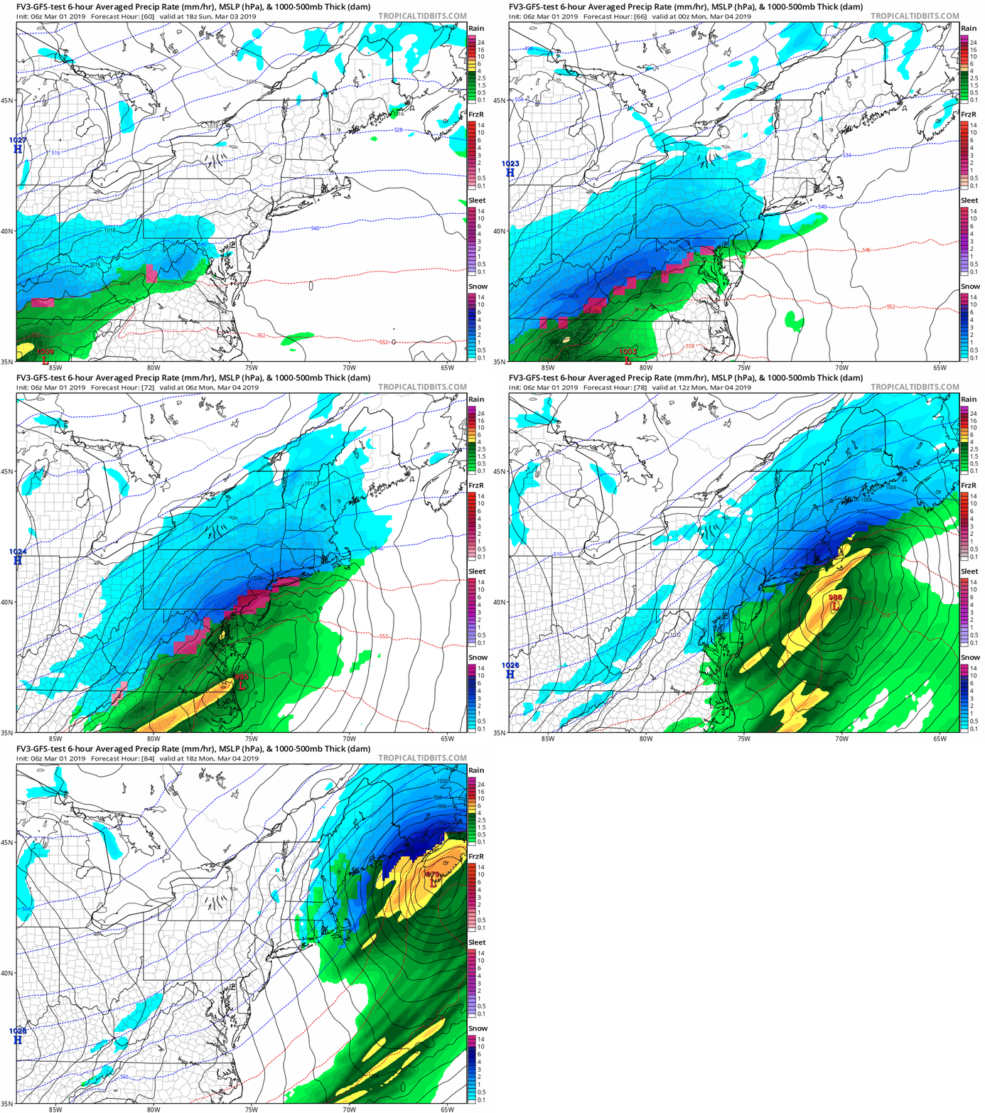
This next storm will follow a similar path, and be a little stronger. This is not a lock by any means… So we need to track this closely.
Please consider these notes then see the animations and two model snapshots below
- The rain/snow line will cut through our region. This is the hard part as to who will be affected.
- The European Model keeps the normally colder suburbs in the snow, but rain elsewhere.
- The American GFS Model shows snow for more of central Maryland
- Both show the freezing line north, so it may be a slushy snow with temps above freezing.
- Monday morning should turn colder, so it is possible to be wet then some freezing before schools open
Snapshots
American GFS shows more snow

European Model shows the snow line farther north

Let’s get through this morning’s clean up and I will have a better look at the return snow for tonight and this storm in my next report.
ALL FITF Apparel
Please share your thoughts, best weather pics/video, or just keep in touch via social media
-
Facebook: Justin Berk, Meteorologist
-
Twitter: @JustinWeather
-
Instagram: justinweather
Related Links:
Winter Outlook
My Winter Outlook 2018-19: Multiple Nor’Easters and more snow
Was Your County Not Included?
Click this map for more on the regional forecast zones
Interactive Snow Report
November 15 Snow Reports- Interactive Map Compared To My Forecast
Winter Snow And Top 5 Wet Years
Snowfall Seasons at Beginning and End of Top 5 Wet Years In Baltimore
Related Winter Outlooks
Solar Cycle: When Sun Spots Are Low We Get More Snow
El Nino Modoki May Enhance Snow Chances
Sweet Spot: Hitting 70ºF on Halloween is followed by more winter snow
Will A Wet Summer Bring A Snowy Winter?
NOAA Winter 2018-2019 Outlook Explained: This Actually Supports Snow
Winter Outlook From Two Different Farmers Almanacs
Maryland Winters: Snowfall Maps and Baltimore Snow History


