Monday Night Update February 11 2019
A Winter Storm Warning is now in effect for the northern and western suburbs of Baltimore. This follows what we have been talking about all afternoon: 1) The storm is trending colder; 2) The places that have snow may double their totals from this morning; 3) There will be a lot of icing into Tuesday morning.
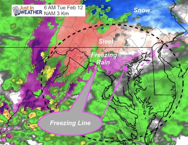
Tuesday Morning Update: Click here to see – Freezing line through Baltimore at 6 AM. Slow thaw this morning plus two more winter events in the next week
This phase of the storm will be reenergizing overnight. That should help to enhance the moisture AND drag colder air down south just a little more. Snow and ice will expand south over the next few hours and through morning.
My first forecast may be proven true already with many places over 5 inches. The transition zone in the 2 to 4 inch range. But there will be extensive icing on top of the snow and farther south tonight.
What About Schools?
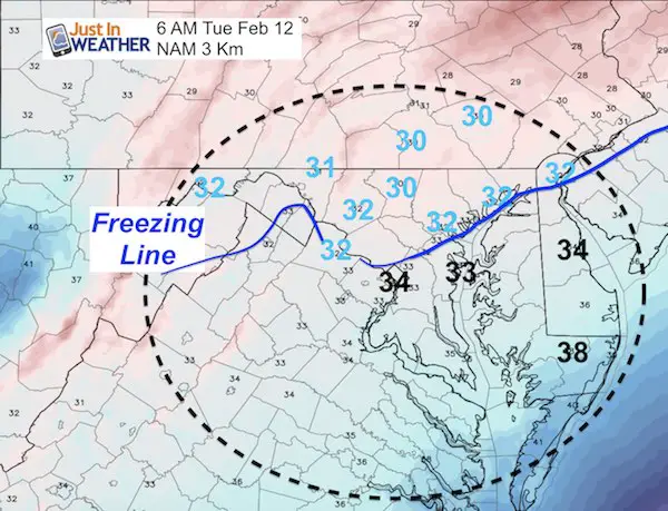
As I said early, I expect a repeat of this morning. No promises, but I believe is is a safe call that those schools that closed Monday, will likely close again. Those that delayed will at least have a delay. Important Note: The maps below show the radar simulation and temperatures. I am attempting to help plot the thaw line in the morning. But there will be a lot of snow and ice that will take time to thaw. It will not happen instantly when temps rise above 32ºF.
Winter Storm Warning
See the NWS associated message below. The scroll down for the latest radar simulation and morning conditions.
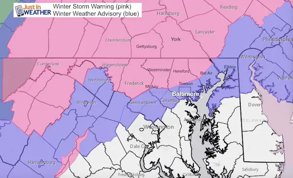
Description Of New Warnings
Winter Storm Warning in Maryland Until 10 AM
* WHERE…Portions of north central and northern Maryland and
Morgan County West Virginia.
NWS Message: Snow, sleet and freezing rain. Total snowfall and sleet accumulations (including snow that has fallen since Sunday
night) of 3 to 7 inches are expected, with isolated totals up to 9 inches possible along the Pennsylvania border in northern Baltimore and northwestern Harford Counties. Freezing rain accumulations of a tenth to a quarter of an inch are also expected through Tuesday morning.
Winter Storm Warning in PA until 4 PM
NWS Message: Snow then heavy mixed precipitation. Additional snow accumulations of 3 to 4 inches and ice accumulations of up to
one half of an inch are expected.
Snow will gradually mix with then change to sleet and freezing rain well after midnight, before
turning to all freezing rain during the mid to late morning hours Tuesday. The temperatures will warm slightly Tuesday to
change the precipitation to plain rain during the mid afternoon.
Compare this to my forecast map at the bottom of this post.
I am celebrating this two part storm with a 20% off sale for all FITF apparel
ALL FITF Apparel is 20% through Tuesday night
Use promo code: SNOWDAY20

Forecast Maps:
When I saw the HRRR Model it looked wild with the switch from snow to sleet, and freezing rain. But that is how the radar has been all say. It is hard to pin down exactly where the transition line will be. But here is the best best now:
Radar Simulation —> slider
[metaslider id=73090]
Daybreak: Another Look
The NAM 3 Km Model supports the same ice line at 6 AM. This should support the call for at least a school delay in these areas, Many up north will cancel classes. Some will wait and reassess…
Morning Radar Simulation
Morning Temperatures: Projected Freezing Line
My Original Snow Call Again
I think this is still holding up pretty well.

Storm Notes:
The snow will be a minor impact on Monday morning.
The transition zone will be between Washington and Baltimore. This region will be within one to two degrees of freezing. That will make or break if there is impact on the roads.
The biggest impact will be snow and icing Monday night into Tuesday morning!
Faster change to rain along and south of I-95
Longer snow and ice impact northwest of the big cities.
- Nearby NW suburbs likely 2″ to 4″ snow is expected. That would be up to 1″ to 2″ of snow from each each round.
- Farther northwest encircled in white could get 5″+. That is potential, not a promise. That would be up to 2″ from round 1 AND 3″+ from round 2 before mixing to ice.
- In Maryland: Northern Harford, northern Baltimore, Carroll, western Howard, Frederick, and Washington Counties
- Southern Pennsylvania: including Adams, York, and Lancaster Counties.
As I noted at the top…. Many places that got snow today may come close to doubling their amount from this morning by Tuesday morning. However, the change over to sleet and freezing rain will compact the snow and weigh it down.
Next Update Will Be Tuesday Morning
Please share your thoughts, best weather pics/video, or just keep in touch via social media
-
Facebook: Justin Berk, Meteorologist
-
Twitter: @JustinWeather
-
Instagram: justinweather

New Colors
We are giving 10% of each sale to Just In Power Kids: Providing FREE holistic care for pediatric oncology patients.


New Partner
Buchanan Kia of Westminster is a supporter of Just In Power Kids and Maryland Trek 6 in August 2019.
Related Links:
Winter Outlook
My Winter Outlook 2018-19: Multiple Nor’Easters and more snow

Interactive Snow Report
November 15 Snow Reports- Interactive Map Compared To My Forecast

Winter Snow And Top 5 Wet Years
Snowfall Seasons at Beginning and End of Top 5 Wet Years In Baltimore

Related Winter Outlooks
Solar Cycle: When Sun Spots Are Low We Get More Snow
El Nino Modoki May Enhance Snow Chances
Sweet Spot: Hitting 70ºF on Halloween is followed by more winter snow
Will A Wet Summer Bring A Snowy Winter?
NOAA Winter 2018-2019 Outlook Explained: This Actually Supports Snow
Winter Outlook From Two Different Farmers Almanacs
Maryland Winters: Snowfall Maps and Baltimore Snow History
