Saturday February 9 2019
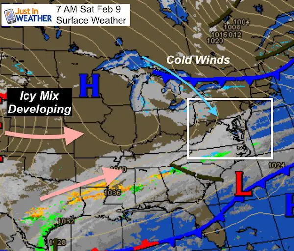
The strong winds have brought back winter in a hurry. The warmth from mid week has been erased as the ground is chilling enough to support stickage from the next winter weather event. We are expecting to have the first flakes arrive Sunday night and into Monday. But looking at the weather map this morning, the ice in the deep south is not very organized. This is along a strong southern jet stream that will lift our way. But the storm has not formed yet. That makes locking the snow, ice, and rain line difficult. But there’s a good idea shown below.
Daily Weather Highlights
Maps for these events are below.
- Today: Dry and cooler. More clouds south, more sun north but they will spread across the sky. Wind chills in the teens and 20s.
- Sunday: Mostly cloudy, chill, and dry.
- Sunday overnight into Monday Morning: Some light snow begins to spread after 8 PM
- Monday: Warming with light mix of rain and snow.
- Monday night: Cold air drops south. Snow mixing to ice with extensive icing west and north of the cities.
- Tuesday: Gradual warming to rain for most. Heavy rain in the afternoon for the cities. Moderate to heavy icing may linger well inland into the afternoon and evening.
Is it too early to get excited for a winter storm?
- This thing has not formed yet! So the location and timing is up for debate.
- Agreement: Some snow Monday, but then more impact snow and ice on Tuesday morning.
- The timing of the heavier snow, ice, and rain I what is not locked in yet.
- The biggest impact will be icing! The snow will be light to moderate in the coldest areas.
Local Weather Stats For February 9, 2019 in Baltimore
Average High: 44ºF
Record High: 68ºF in 2001
Average Low: 26ºF
Record Low: 8ºF in 1899
*Record Snow: 5.0″ in 1936
Sunrise: 7:05 AM
Sunset 5:36 PM
*Daylight = 2:16 longer than yesterday
*Bay Water Temperature = 36ºF at Thomas Pt. Light House
Keep In Touch Every Day
Just in case you don’t get all posts on your social media feed, stay up to date with the latest info…
Click here to sign up for email alerts…. Be the first to hear any new weather.

New Partner
Buchanan Kia of Westminster is a supporter of Just In Power Kids and Maryland Trek 6 in August 2019.
Today: Cold Air And Chilly Winds
Morning Temps

Wind Chills


Afternoon Highs

Sunday:
 |
 |
Storm Stuff:
- There is a lot of agreement but some details to be sorted out.
- First, check out the Canadian GEM Model animation. This shows the snow arriving late Sunday night, then the snow and ice developing Monday and Tuesday morning. The transition to heavy rain around the Chesapeake Bay on Tuesday.
- The NAM 3 KM Model ha done a good job with our winter events. Her is shows the arrival Sunday night. I am skeptical of the lack of moisture Monday morning. This contradicts the European Model shown below.
Storm Animation
Sunday Night Simulation —> slider
NAM 3 Km
[metaslider id=72743]
Storm Simulation —> slider
European Model
[metaslider id=72762]
Storm Notes:
The snow will be a minor impact on Monday morning.
The biggest impact will be icing Monday night and Tuesday morning!
Faster change to rain along and south of I-95
Longer snow and ice impact northwest of the big cities
- In Maryland: Northern Harford, Baltimore, Carroll, western Howard, Frederick, and Washington Counties
- Southern Pennsylvania: including Adams, York, and Lancaster Counties.
FITF and SnowStix

Temperature Outlook
The high temps might be deceiving for Monday and Tuesday. The impact times below freezing will be Monday morning and night, and Tuesday morning.
A warm up next weekend, then another push of winter next week.

Please share your thoughts, best weather pics/video, or just keep in touch via social media
-
Facebook: Justin Berk, Meteorologist
-
Twitter: @JustinWeather
-
Instagram: justinweather

New Colors
We are giving 10% of each sale to Just In Power Kids: Providing FREE holistic care for pediatric oncology patients.

Related Links:
Winter Outlook
My Winter Outlook 2018-19: Multiple Nor’Easters and more snow

Interactive Snow Report
November 15 Snow Reports- Interactive Map Compared To My Forecast

Winter Snow And Top 5 Wet Years
Snowfall Seasons at Beginning and End of Top 5 Wet Years In Baltimore

Related Winter Outlooks
Solar Cycle: When Sun Spots Are Low We Get More Snow
El Nino Modoki May Enhance Snow Chances
Sweet Spot: Hitting 70ºF on Halloween is followed by more winter snow
Will A Wet Summer Bring A Snowy Winter?
NOAA Winter 2018-2019 Outlook Explained: This Actually Supports Snow
Winter Outlook From Two Different Farmers Almanacs
Maryland Winters: Snowfall Maps and Baltimore Snow History
