Friday February 1 2019
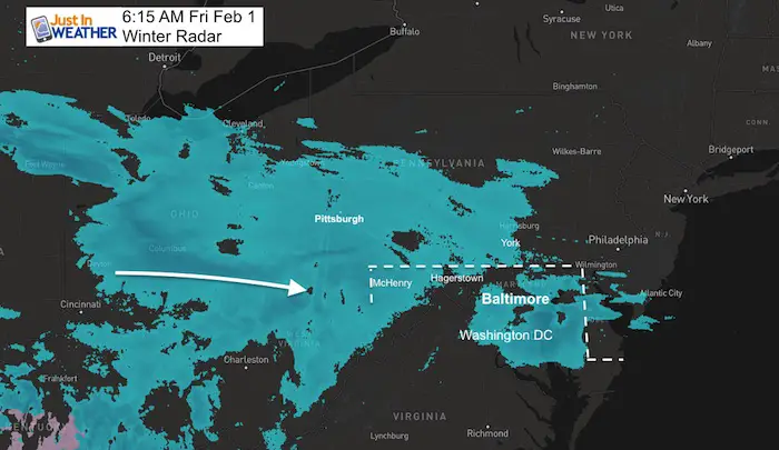
Light snow will be moving in to our area this morning. Some has already shown up on radar, but the air is so cold and dry, a lot has not reached the ground. Gradually the air will saturate and we will get some stickage during the morning. As this develops, the initial snow may impact Washington to Annapolis only this morning. Baltimore to southern PA continue through the day. The Eastern Shore and even the beaches will get snow and slick roads this afternoon and early evening.
One problem is that it is so cold, anything that falls will stick. Thursday at Baltimore’s BWI broke a 70 year old record for the coldest afternoon for the date with a high of only 22ºF. We are in the deep freeze and will remain there all day. Here is a look at the temperatures this morning. Note that with air this cold, the snowflakes will be dry and fluffy. That means they blow around easier, but also we can get more to fluff up with less moisture.
Temperatures at 6 AM

Morning Radar
Winter Weather Advisory
Washington to Annapolis should only have impact this morning.
York and Lancaster PA were not included, but I think they should be. Plan for snow to slow you down on the roads there.
Cecil and Kent Co should have been in the Advisory as well. I don’t make those, but can alert you to be prepared.

Local Weather Stats For February 1, 2019 in Baltimore
Average High: 42ºF
Record High: 75ºF in 2002
Average Low: 25ºF
Record Low: 7ºF in 1965
*Record Snow: 9.0″ in 1934
Sunrise: 7:13 AM
Sunset 5:26 PM
*Daylight = 2:05 longer than yesterday
*Bay Water Temperature = 34ºF at Thomas Pt. Light House
Keep In Touch Every Day
Just in case you don’t get all posts on your social media feed, stay up to date with the latest info…
Click here to sign up for email alerts…. Be the first to hear any new weather.
Morning Temperatures

Morning—> slider (has been updated)
[metaslider id=72440]
Temperatures at Noon

Afternoon—> slider
[metaslider id=72451]
Love Snow and Love Maryland Sale
It’s less than 15 days until Valentine’s Day
Any Love Snow or Love Maryland item is 15% Off until Sunday.
Use promo code: LOVESNOW15
The first 15 orders get our new FITF bag. Orders after that get another surprise gift.

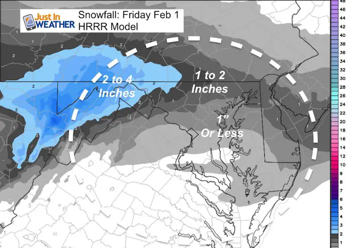
Snow Total: Increased A Little On North End
Again, just enough to coat the ground and be a nuisance.
Evening Temperatures


New Partner
Buchanan Kia of Westminster is a supporter of Just In Power Kids and Maryland Trek 6 in August 2019.
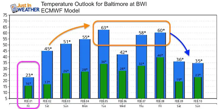
Temperature Outlook
We thaw this weekend and warm up even more Sunday. The gig warm up next week. Often these end up warmer and last longer than first displayed. But, we will get a reality cold check next weekend.
Please share your thoughts, best weather pics/video, or just keep in touch via social media
-
Facebook: Justin Berk, Meteorologist
-
Twitter: @JustinWeather
-
Instagram: justinweather
Related Links:
Winter Outlook
My Winter Outlook 2018-19: Multiple Nor’Easters and more snow

Interactive Snow Report
November 15 Snow Reports- Interactive Map Compared To My Forecast

Winter Snow And Top 5 Wet Years
Snowfall Seasons at Beginning and End of Top 5 Wet Years In Baltimore

Related Winter Outlooks
Solar Cycle: When Sun Spots Are Low We Get More Snow
El Nino Modoki May Enhance Snow Chances
Sweet Spot: Hitting 70ºF on Halloween is followed by more winter snow
Will A Wet Summer Bring A Snowy Winter?
NOAA Winter 2018-2019 Outlook Explained: This Actually Supports Snow
Winter Outlook From Two Different Farmers Almanacs
Maryland Winters: Snowfall Maps and Baltimore Snow History
