Thursday January 31 2019
The core of the cold air is over us this morning. The official temperatures at regional airports may not be representative of what your home or car thermometers display. Many areas north of Baltimore are below zero and colder wind chills. The rapid hard freeze can be responsible for a rare event called a frost quake. It is possible that the soggy soil froze below the surface. As that happens, it expands and can make a loud pop or boom sound. It may not be enough to measure on the Richter Scale, rather soon like a loud truck slamming nearby.
Many schools are on a two hour delay, some will reevaluate. My district explained that they realize temps will not warm much over that time. But it allows for school buildings to warm up and kids to get to school AFTER rush hour. Here’s the comparison:
Temperatures and Wind Chill at 7 AM


Temperatures and Wind Chill at 9 AM

Two records that were to be challenged today at Baltimore’s BWI:
Low Temperatures: +4ºF in 1966. As of 7 AM the low was 6ºF on the hours (may reach between hourly reports)
Coldest Max Temp: 22 in 1948 (very possible)
This Afternoon


Keep In Touch Every Day
Just in case you don’t get all posts on your social media feed, stay up to date with the latest info…
Click here to sign up for email alerts…. Be the first to hear any new weather.
Local Weather Stats For January 31, 2019 in Baltimore
Average High: 42ºF
Record High: 69ºF in 1947
Average Low: 25ºF
Record Low: 4ºF in 1866
*Record Snow: 3.7″ in 1985
Sunrise: 7:14 AM
Sunset 5:24 PM
*Daylight = 2:02 longer than yesterday
*Bay Water Temperature = 36ºF at Thomas Pt. Light House
Keep In Touch Every Day
Just in case you don’t get all posts on your social media feed, stay up to date with the latest info…
Click here to sign up for email alerts…. Be the first to hear any new weather.
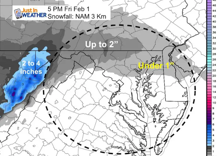
Snow Friday
At this time, the clipper should bring light snow and only affect the northern half of our region. The snow simulation here shows it north of Rt 50 or I-70 with any stickage.
Simulation—> slider
[metaslider id=72354]
How Much Snow?
Love Snow and Love Maryland Sale
It’s less than 15 days until Valentine’s Day
Any Love Snow or Love Maryland item is 15% Off until Sunday.
Use promo code: LOVESNOW15
The first 15 orders get our new FITF bag. Orders after that get another surprise gift.


New Partner
Buchanan Kia of Westminster is a supporter of Just In Power Kids and Maryland Trek 6 in August 2019.
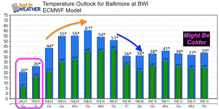
Temperatures Friday


Temperature Outlook
The Jet Stream will lift the Polar Vortex to our north and the return of very warm air next week could bring us to near 60ºF. Then another arctic blast arrive by Valentine’s Day.
Temperature Forecast
The Mid February arctic blast may not be reflected well here. But you can see the 60s next week
Please share your thoughts, best weather pics/video, or just keep in touch via social media
-
Facebook: Justin Berk, Meteorologist
-
Twitter: @JustinWeather
-
Instagram: justinweather
Related Links:
Winter Outlook
My Winter Outlook 2018-19: Multiple Nor’Easters and more snow

Interactive Snow Report
November 15 Snow Reports- Interactive Map Compared To My Forecast

Winter Snow And Top 5 Wet Years
Snowfall Seasons at Beginning and End of Top 5 Wet Years In Baltimore

Related Winter Outlooks
Solar Cycle: When Sun Spots Are Low We Get More Snow
El Nino Modoki May Enhance Snow Chances
Sweet Spot: Hitting 70ºF on Halloween is followed by more winter snow
Will A Wet Summer Bring A Snowy Winter?
NOAA Winter 2018-2019 Outlook Explained: This Actually Supports Snow
Winter Outlook From Two Different Farmers Almanacs
Maryland Winters: Snowfall Maps and Baltimore Snow History
