Wednesday January 30 2019
The arctic front is on the move and has prompted a Snow Squall Warning in parts of central Maryland and south central Pennsylvania from the National Weather Service. This will be quick but potentially dangerous as a heavy burst of snow and whiteout conditions develop. I expect this to be very likely to extend eastward into metro Baltimore around lunchtime.
The snow will be dry and fly around easily.
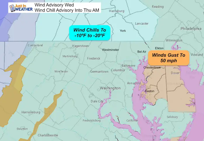
Temperatures Drop Fast Behind The Front

This is as the winds increase and the temps drop. The Wind Advisory for gusts to 50 mph and Wind Chill Advisory for the Real Feel Temps down -10ºF to -20ºF is still to follow.
Below is a look at the conditions at 10AM and the modeling at that time. But first, this rare Snow Squall Advisory from NWS in State College PA. If any more are issued, I will add them to this post.
Snow Squall Warning in Maryland

National Weather Service Statement
* Snow Squall Warning for…
Washington County in north central Maryland…
Northwestern Frederick County in north central Maryland…
Northeastern Jefferson County in the Panhandle of West Virginia…
Morgan County in the Panhandle of West Virginia…
Northern Berkeley County in the Panhandle of West Virginia…
* Until 1115 AM EST.
* At 1013 AM EST, a dangerous snow squall was located moving across
Washington County Maryland and easternmost West Virginia, moving
east at 30 mph.
HAZARD…Poor visibility in snow and blowing snow. Wind gusts
greater than 30 mph.
SOURCE…Radar and webcam indicated.
IMPACT…Dangerous life-threatening travel.
* For those driving on Interstate 68, and other high speed highways
in the warning area, this is especially dangerous as visibility
will rapidly drop and pavement may become rapidly icy from a small
amount of snow accumulation.
PRECAUTIONARY/PREPAREDNESS ACTIONS…
Reduce your speed and turn on headlights! During snow squalls, the
visibility may suddenly drop to near zero in whiteout conditions.
Snow Squall Warning in Pennsylvania

At 1004 AM EST, a dangerous snow squall was located along a line
extending from Grover to near Snyder-Middleswart State Park to near
Doylesburg to 6 miles east of Hancock, moving east at 55 mph.
HAZARD…Whiteout conditions. Zero visibility in heavy snow and
blowing snow. Wind gusts greater than 30 mph.
SOURCE…Radar and webcams.
IMPACT…Dangerous life-threatening travel.
* For those driving on Interstate 80, this includes areas between the
Lamar and Nescopek exits, specifically from mile markers 174 to
247.
This includes the following Interstates…
Interstate 70 from mile markers 161 to 170.
The Pennsylvania Turnpike from mile markers 169 to 258.
Interstate 81 between mile markers 1 and 81…and from mile markers
98 to 139.
Interstate 83 from mile markers 9 to 50.
Interstate 180 from mile markers 1 to 29.
Interstate 283 from mile markers 0 to 2.
Tracking From 10 AM
I have tracked plotted this east of Altoona and west of Chambersburg in PA. Compare that to the HRRR Model initialization below.

Snow Squall Timeline —> slider
This is moving faster than the modeling, so consider these plots perhaps 30 minutes behind schedule.
That brings this into central Maryland between 11:30 AM and 1 PM
[metaslider id=72319]
Wind Advisory and Wind Chill Advisory
Temperature Timeline —> slider
[metaslider id=72274]
Wind Chill Timeline —> slider
[metaslider id=72287]
FITF Gear To Stay Warm

Thursday Morning
It will be dangerously cold. I expect many schools will consider this for delays or cancellations.


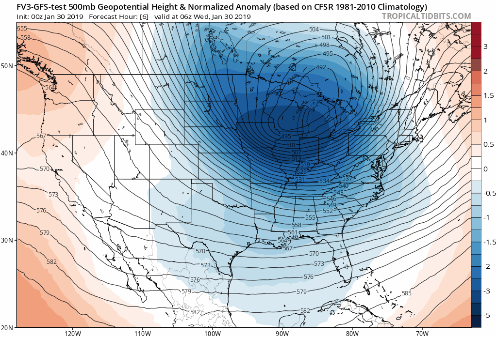
Jet Stream Animation
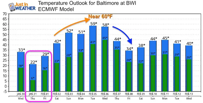
Watch how quickly this lifts away and we being to thaw by Friday and this weekend. The temperature outlook below shows us near 60ºF next week, before cooling down again.
Temperature Outlook
Keep In Touch Every Day
Just in case you don’t get all posts on your social media feed, stay up to date with the latest info…
Click here to sign up for email alerts…. Be the first to hear any new weather.
Please share your thoughts, best weather pics/video, or just keep in touch via social media
-
Facebook: Justin Berk, Meteorologist
-
Twitter: @JustinWeather
-
Instagram: justinweather
FITF Hats
After selling out twice, the hats are restocked and ready to ship.


New Partner
Buchanan Kia of Westminster is a supporter of Just In Power Kids and Maryland Trek 6 in August 2019.
Related Links:
Winter Outlook
My Winter Outlook 2018-19: Multiple Nor’Easters and more snow

Interactive Snow Report
November 15 Snow Reports- Interactive Map Compared To My Forecast

Winter Snow And Top 5 Wet Years
Snowfall Seasons at Beginning and End of Top 5 Wet Years In Baltimore

Related Winter Outlooks
Solar Cycle: When Sun Spots Are Low We Get More Snow
El Nino Modoki May Enhance Snow Chances
Sweet Spot: Hitting 70ºF on Halloween is followed by more winter snow
Will A Wet Summer Bring A Snowy Winter?
NOAA Winter 2018-2019 Outlook Explained: This Actually Supports Snow
Winter Outlook From Two Different Farmers Almanacs
Maryland Winters: Snowfall Maps and Baltimore Snow History
