Thursday January 17 2019
The next few days will be very fast and complex with multiple weather events. The first one tonight is why we have a Winter Weather Advisory. Earlier Central Maryland expanded the advisory south. One factor that needs to be considered… Some ground surfaces might be frozen. So even with snow or a windy mix falling in southern zones while the air is above freezing, the colder ground may support stickage and or icing.
The second event will be Saturday into Sunday. Now, southern Pennsylvania has been added to the advisory party tonight. We expected that given their colder temps and 1 to 2 inches of snow. Just late for NWS to add them. But, you will notice a different color shading there. This is because they are ALSO under a Winter Storm Watch for Saturday Afternoon until Sunday Afternoon. I’ll explain in a moment. I do want to point out that this area is covered by The National Weather Service State College PA Office. That is why some counties in our area get advisories or warnings at different times. It’s when their office issues them.
Winter Weather Advisory Tonight

More On Tonight’s Weather Timeline Below
Weekend: Winter Storm Watch
The Winter Storm Watch in Pennsylvania is for heavy snow AND icing THIS WEEKEND. It is likely that a major ice event lingers here while much of Maryland turns to rain, before back to snow and icing Sunday. I will have an update on this event later this evening.
Here is what NWS posted:
Counties: Franklin-Perry-Dauphin-Schuylkill-Lebanon-Cumberland-Adams-York-
Lancaster-
Including the cities of Chambersburg, Newport, Harrisburg,
Hershey, Pottsville, Lebanon, Carlisle, Gettysburg, York,
and Lancaster
...WINTER STORM WATCH IN EFFECT FROM SATURDAY AFTERNOON THROUGH
SUNDAY AFTERNOON...

* WHAT...Snow followed by heavy mixed precipitation possible.
  Total snow accumulations of 2 to 5 inches, with localized
  amounts up to 10 inches in higher elevations possible. Ice
  accumulations of one tenth to one quarter of an inch are
  possible.

* WHERE...Lower Susquehanna Valley.

* WHEN...From Saturday afternoon through Sunday afternoon.

* ADDITIONAL DETAILS...Plan on difficult travel conditions.
  Significant reductions in visibility are possible.
Back To Tonight’s Weather
Below is a look at two snow timelines to show the first round later afternoon and the overnight push of snow. Also a look at snow potential, which will be generally an inch or two in the affected areas.
The weekend event will be bigger, and as I wrote yesterday… Snow Saturday evening will change to rain, but northern areas could remain icy. Then the return to snow Sunday will come with arctic air. The snow totals are not as important as the flash freeze. Quick icing for many areas expected Sunday afternoon.
Snow Day Kit Sale: Though Noon Friday
Use Promocode: SNOWDAYPLEASE to get 15% to encourage more snow
NEW: Individual Items Are Now Available A La Carte.

Snow Simulations: Two Models To Compare
HRRR Model —> slider
The first wave of snow showers will be on the north side this evening. It may be enough to impact late activities and I expect some schools may cancel them. The main snow will be after 10 PM and end between 2 and 4 AM Friday.
[metaslider id=71150]
Temperatures (When The Snow Ends)

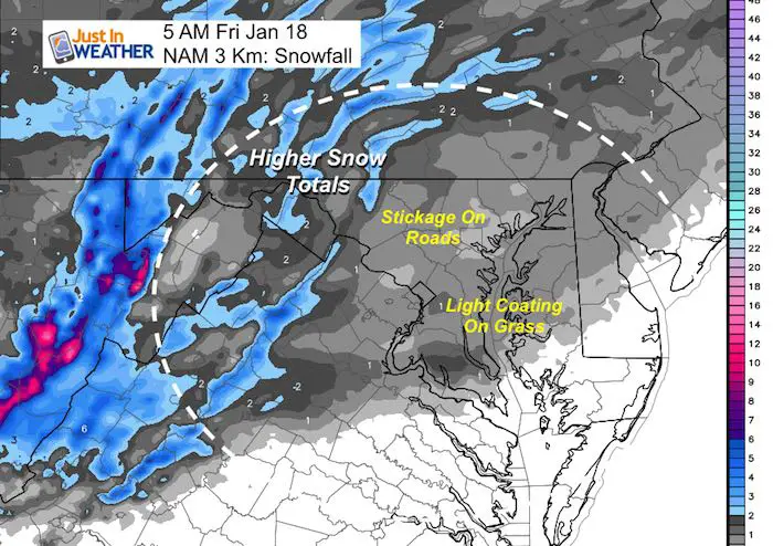
NAM 3 Km Model
This product has the freezing line, which I highlighted. This tells us the best chance for icy roads to the north. But we need to consider the cold ground for the rest of the Winter Weather Advisory area
Simulation —> slider
[metaslider id=71173]
Temperatures: Will Thaw
I expect that if there are school delays, that is all that will be needed. Temps will be rising during the morning and all will be above freezing during the day


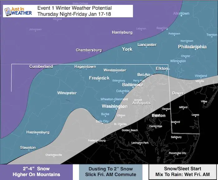
My Call for Snowfall:
This was my original forecast and it remains… The area shaded in white was added to the Winter Weather Advisory. That is where it should still be above freezing, but the cold ground might support stickage.
NAM Model Snowfall
My Next Update Will Be This Evening
Keep In Touch Every Day
Just in case you don’t get all posts on your social media feed, stay up to date with the latest info…
Click here to sign up for email alerts…. Be the first to hear any new weather forecasts

New Partner
Buchanan Kia of Westminster is a supporter of Just In Power Kids and Maryland Trek 6 in August 2019.

We are giving 10% of each sale to Just In Power Kids: Providing FREE holistic care for pediatric oncology patients.
FITF and SnowStix Available NOW

Please share your thoughts, best weather pics/video, or just keep in touch via social media
-
Facebook: Justin Berk, Meteorologist
-
Twitter: @JustinWeather
-
Instagram: justinweather
Keep In Touch Every Day
Click here to sign up for email alerts…. Just in case you don’t get the post on your social media feed
Related Links:
Winter Outlook
My Winter Outlook 2018-19: Multiple Nor’Easters and more snow

Interactive Snow Report
November 15 Snow Reports- Interactive Map Compared To My Forecast

Winter Snow And Top 5 Wet Years
Snowfall Seasons at Beginning and End of Top 5 Wet Years In Baltimore

Related Winter Outlooks
Solar Cycle: When Sun Spots Are Low We Get More Snow
El Nino Modoki May Enhance Snow Chances
Sweet Spot: Hitting 70ºF on Halloween is followed by more winter snow
Will A Wet Summer Bring A Snowy Winter?
NOAA Winter 2018-2019 Outlook Explained: This Actually Supports Snow
Winter Outlook From Two Different Farmers Almanacs
Maryland Winters: Snowfall Maps and Baltimore Snow History
