Sunday January 13 2019
Snow reports this morning already seem to verify the lower end of the final forecast in many areas. As always, there are some lower but also some higher spots. There is more to this storm and why my snow expectation along with many others increased: The second part of the storm is starting to take shape now.
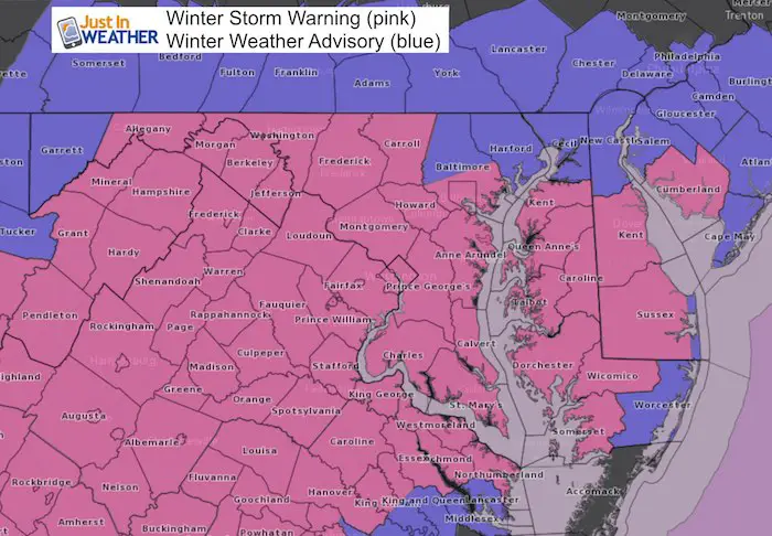
Winter Storm Warnings for most extended to Midnight!
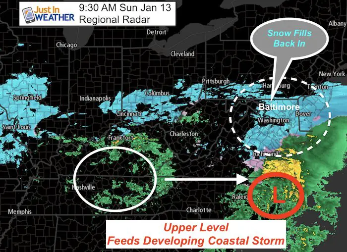
Looking at the radar may be deceiving. The storm is not done. That was the issue all week with low or high forecast totals. The reason for my bump and the increase to Winter Storm Warning across much of our region has been what we are waiting for now: Phase Two!
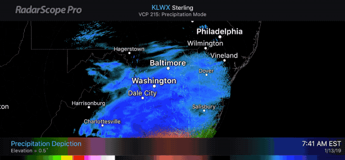
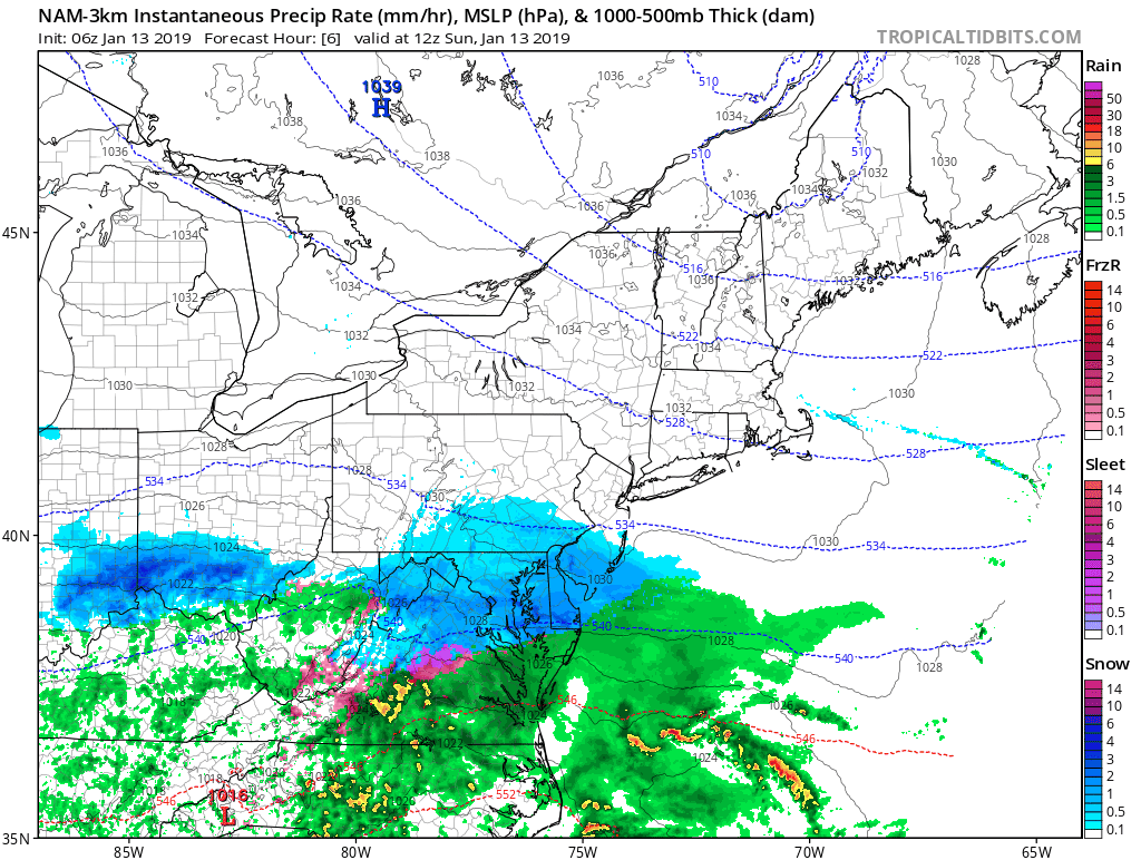
Here is the morning radar that appears to be breaking up on the north side. That is just the lull during the storm transition. The Coastal Storm will develop as upper level energy transfers east. That will fill in the radar again.
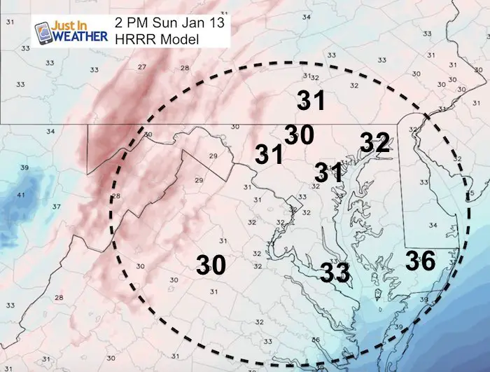
Southern Maryland: Some thawing today, but snow returns this evening and tonight. That will lead to more ice problems.
Compare this to the new updated snow simulation slider below. We are not done yet.
Keep In Touch Every Day
Just in case you don’t get all posts on your social media feed, stay up to date with the latest info…
Click here to sign up for email alerts…. Be the first to hear any new weather forecasts
Radar Loop
Snow Simulation —> slider
As the coastal storm develops, to will appear as if snow is getting heavier and spreading north. Also, rain may move north in southern Maryland and lower Delmarva. This will with back to snow by evening. Snow will reach the beaches again tonight.
[metaslider id=70816]
FULL FORECAST –
Please click here to see my complete morning forecast with additional snow totals and interactive snow report map.
Cold Enough To Stick
Mid Afternoon:
Still below freezing for many. Brief thaw in southern Maryland but that will only add to icing.
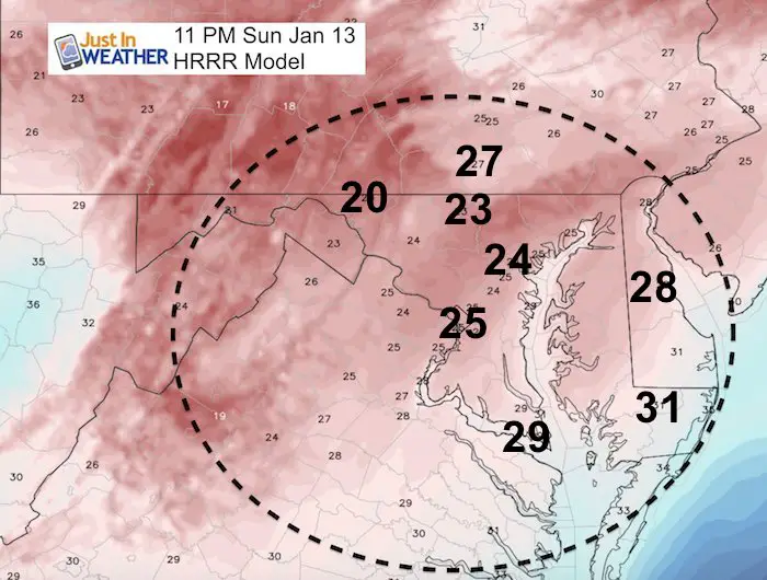
Tonight:
As the cold air and snow returns, any places that were wet will ice up. Expect road problems and school issues Monday morning.
Keep In Touch Every Day
Just in case you don’t get all posts on your social media feed, stay up to date with the latest info…
Click here to sign up for email alerts…. Be the first to hear any new weather forecasts
Snowstix- We Need You To Measure Snow Too
We are giving 10% of each sale to Just In Power Kids: Providing FREE holistic care for pediatric oncology patients.

School Impact Monday Morning?
It looks like there will still be clean while in the freeze. The lower Eastern Shore will have fresh snow until Monday morning to deal.
Maybe These Snow Day Kits Worked- Get in on the action
NEW: Individual Items Are Now Available A La Carte.

Winter Storm Warnings And Advisories remain in place today
Winter Storm Warnings for most extended to Midnight! Lower Eastern Shore until Monday morning.
Storm Forecast Loop: NAM 3 Km
FITF and SnowStix Available NOW

Please share your thoughts, best weather pics/video, or just keep in touch via social media
-
Facebook: Justin Berk, Meteorologist
-
Twitter: @JustinWeather
-
Instagram: justinweather
Keep In Touch Every Day
Click here to sign up for email alerts…. Just in case you don’t get the post on your social media feed
Related Links:
Winter Outlook
My Winter Outlook 2018-19: Multiple Nor’Easters and more snow

Interactive Snow Report
November 15 Snow Reports- Interactive Map Compared To My Forecast

Winter Snow And Top 5 Wet Years
Snowfall Seasons at Beginning and End of Top 5 Wet Years In Baltimore

Related Winter Outlooks
Solar Cycle: When Sun Spots Are Low We Get More Snow
El Nino Modoki May Enhance Snow Chances
Sweet Spot: Hitting 70ºF on Halloween is followed by more winter snow
Will A Wet Summer Bring A Snowy Winter?
NOAA Winter 2018-2019 Outlook Explained: This Actually Supports Snow
Winter Outlook From Two Different Farmers Almanacs
Maryland Winters: Snowfall Maps and Baltimore Snow History
