Sunday December 23 2018
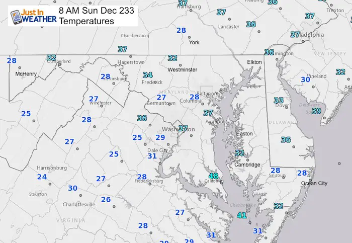
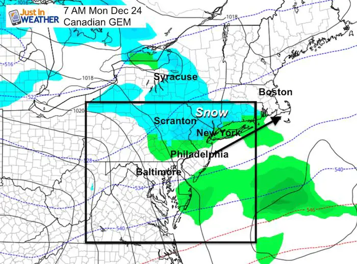
Cold and quiet this morning but a quick moving system will bring in some light rain and mountain snow tonight. The rush for last minute shopping or even travel should be OK in the daylight. But as rain showers move in for most of us, there will be snow developing in the western Maryland mountains AND to our north in the Lehigh Valley of Pennsylvania. Snow may accumulate a dusting to 2 inches there.
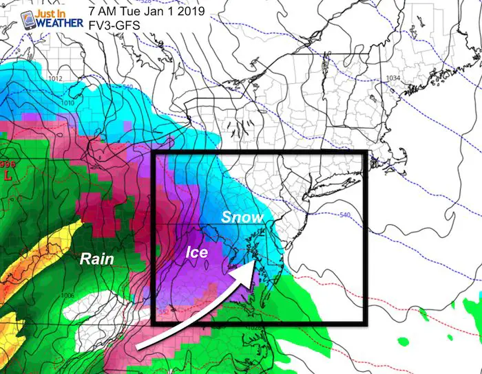
The good news is that Christmas Day will be seasonably cold and quiet, then we warm for another end of week rain storm. Then the pattern begins to shift to try and bring an event around New Years Day 2019. This has been consistently shown on some models to bring us a snow, ice, rain mix. I know it is early, but I wanted to show it in the outlook below.
Local Weather Stats For December 23 in Baltimore
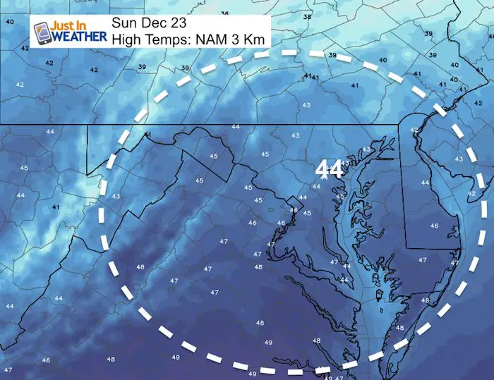
Average High: 43ºF
Record High: 69ºF in 1990
Average Low: 26ºF
Record Low: 0ºF in 1960
*Record Snow: 8.0″ in 196
Sunrise: 7:23 AM
Sunset 4:47 PM
*Daylight = 0:05 longer than yesterday
*Bay Water Temperature = 43ºF at Thomas Pt. Light House
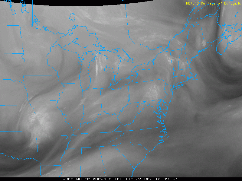
Morning Set Up
The satellite shows the system in Missouri this morning that will reach us tonight.
Morning Temperatures
High Temperatures
Rain and Snow Timeline —> slider
[metaslider id=70005]
Snow To Our North Christmas Eve Morning
Looking Ahead
Christmas will be quiet, followed by another end of week rain event. That will be followed by colder air to feed into the next system may result in a snow and ice event around New Years Day
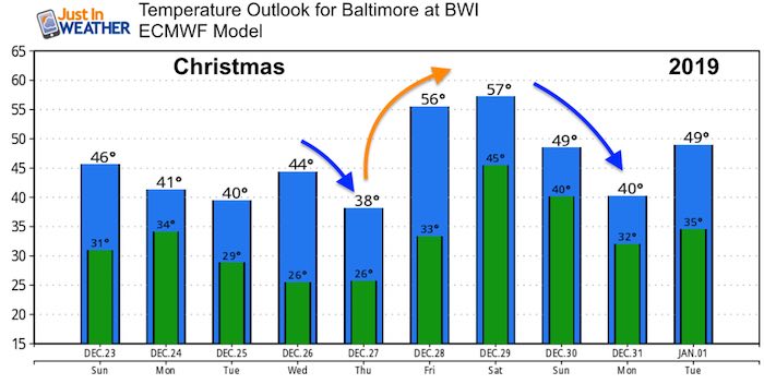
The Jet Stream will be trending warming Dec 26 to 30, then turn colder and more stormy into the new year.
New Years Day
Storm Animation
Snow Day Kit
Our ritual the night before a storm is finally in one kit. Maybe if more Maryland kids had this, the storm would reach us 🙂
- This includes a very soft raglan Tee printed inside out with #FITF AND the check list, #FITF spoon for under your pillow, ice cube tray with snowflake shapes, chalk, a #FITF wrist-band, a mini SnowStix, and a bag to carry it all in.
- New Orders are likely to be delivered after the holiday.
- This will also help us give a free Snow Day Kit to each of the Just In Power Kids.

FITF and SnowStix Stores are now OPEN

Keep In Touch Every Day
Click here to sign up for email alerts…. Be the first to hear the big news over the weekend
Also- Just in case you don’t get the post on your social media feed
Please share your thoughts, best weather pics/video, or just keep in touch via social media
-
Facebook: Justin Berk, Meteorologist
-
Twitter: @JustinWeather
-
Instagram: justinweather
Keep In Touch Every Day
Click here to sign up for email alerts…. Just in case you don’t get the post on your social media feed
Related Links:
Winter Outlook
My Winter Outlook 2018-19: Multiple Nor’Easters and more snow

Interactive Snow Report
November 15 Snow Reports- Interactive Map Compared To My Forecast

Winter Snow And Top 5 Wet Years
Snowfall Seasons at Beginning and End of Top 5 Wet Years In Baltimore

Related Winter Outlooks
Solar Cycle: When Sun Spots Are Low We Get More Snow
El Nino Modoki May Enhance Snow Chances
Sweet Spot: Hitting 70ºF on Halloween is followed by more winter snow
Will A Wet Summer Bring A Snowy Winter?
NOAA Winter 2018-2019 Outlook Explained: This Actually Supports Snow
Winter Outlook From Two Different Farmers Almanacs
Maryland Winters: Snowfall Maps and Baltimore Snow History

Snowstix- We Need You To Measure Snow Too
We are giving 10% of each sale to Just In Power Kids: Providing FREE holistic care for pediatric oncology patients.
