Thursday December 20 2018
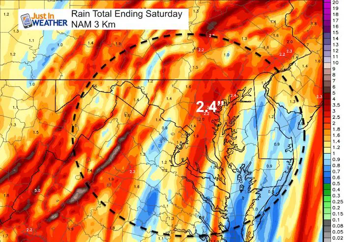
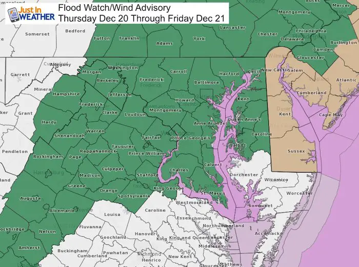
The rain has already moved in mid day as expected. I was driving between Frederick and Towson in very wet conditions on the roads, but the mist and light rain was not showing up well on radar. There is a lot more on the way to justify the Flood Watch. Over 2 inches is looking more likely and Baltimore may very well have the first 70 inch rain season on record.
What is also interesting and a little weird about this storm will be the warm air pumping in. In the rain early this afternoon, my car was showing temperatures in the upper 30s. Chilly, raw stuff. Just too warm for snow, but much warmer air is on the way. Check out these temperatures around the region in the temperature timeline. The expansion of 60s after midnight and Friday morning will surge into eastern PA. It is possible some kids will want to wear shorts to school on their last day before Christmas break.
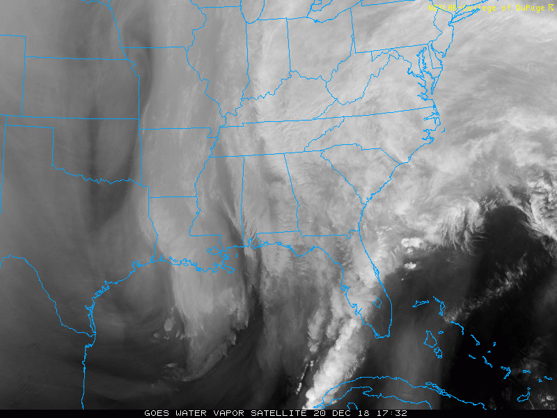
Satellite Loop: Our Storm
Yet another system from the Gulf of Mexico. This one is once again bringing tropical moisture up our way.
Temperature Timeline –> slider
[metaslider id=69908]
Rain Timeline Thursday into Friday Morning — >slider
This is the HRRR Model
[metaslider id=69838]
Rain Timeline Friday Morning — >slider
This is the NAM 3 Km Model showing more rain Friday morning….
[metaslider id=69853]
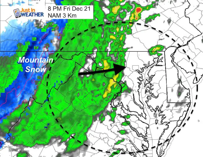
Friday Evening
Showers will return on Friday evening into Saturday morning, while heavy snow comes back to cover the mountains.
The good news is that the system should be moving out in the morning and most of the weekend should be dry for us.
Rain Record:
Before today’s rain… Here is how we have stacked up this year compared to others… and our 2018 wet calendar.


Outlook (Just A Quick Look)
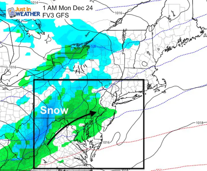
Monday Christmas Eve could bring some chilly rain or snow. This is snapshot of the little system just after midnight into Monday morning.
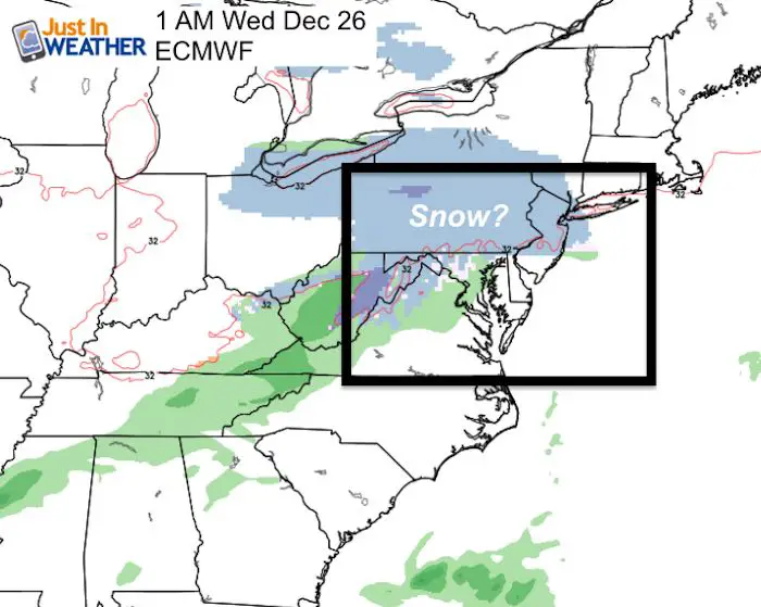
Christmas Snow? Right now the European Model is still the only one showing this event, but it pushed back the snow until after midnight on early morning of the 26th
Snow Day Kit
Our ritual the night before a storm is finally in one kit. Maybe if more Maryland kids had this, the storm would reach us 🙂
- This includes a very soft raglan Tee printed inside out with #FITF AND the check list, #FITF spoon for under your pillow, ice cube tray with snowflake shapes, chalk, a #FITF wrist-band, a mini SnowStix, and a bag to carry it all in.
- New Orders are likely to be delivered after the holiday.
- This will also help us give a free Snow Day Kit to each of the Just In Power Kids.

FITF and SnowStix Stores are now OPEN

Keep In Touch Every Day
Click here to sign up for email alerts…. Be the first to hear the big news over the weekend
Also- Just in case you don’t get the post on your social media feed
Please share your thoughts, best weather pics/video, or just keep in touch via social media
-
Facebook: Justin Berk, Meteorologist
-
Twitter: @JustinWeather
-
Instagram: justinweather
Keep In Touch Every Day
Click here to sign up for email alerts…. Just in case you don’t get the post on your social media feed
Related Links:
Winter Outlook
My Winter Outlook 2018-19: Multiple Nor’Easters and more snow

Interactive Snow Report
November 15 Snow Reports- Interactive Map Compared To My Forecast

Winter Snow And Top 5 Wet Years
Snowfall Seasons at Beginning and End of Top 5 Wet Years In Baltimore

Related Winter Outlooks
Solar Cycle: When Sun Spots Are Low We Get More Snow
El Nino Modoki May Enhance Snow Chances
Sweet Spot: Hitting 70ºF on Halloween is followed by more winter snow
Will A Wet Summer Bring A Snowy Winter?
NOAA Winter 2018-2019 Outlook Explained: This Actually Supports Snow
Winter Outlook From Two Different Farmers Almanacs
Maryland Winters: Snowfall Maps and Baltimore Snow History

Snowstix- We Need You To Measure Snow Too
We are giving 10% of each sale to Just In Power Kids: Providing FREE holistic care for pediatric oncology patients.
