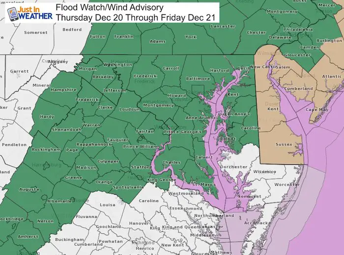
Thursday December 20 2018
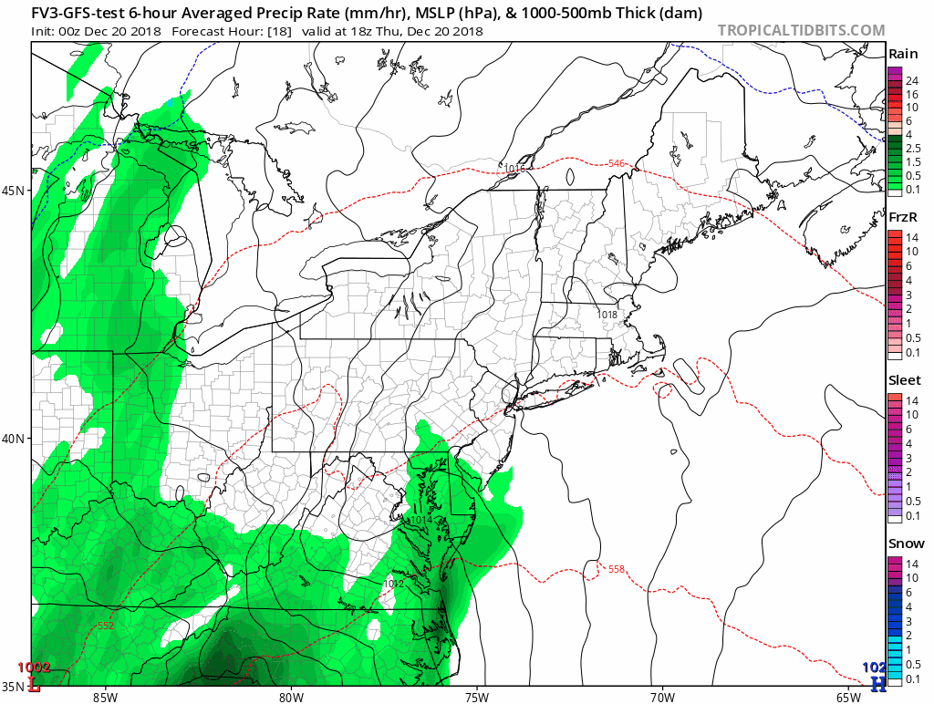
We have yet another Flood Watch across our area for the widespread 1 to 2 inches of rain. It will begin as showers this morning, then steady rain this afternoon and heavy rain tonight. In addition to flooding, there is another risk some trees can fall over. Especially where winds will be strongest. A Wind Advisory is in place across Delaware and the New Jersey coast for gusts up to 50 mph. But there is something weird about this storm that needs to be explained with all of the other details.
Storm Key (Weird) Notes:
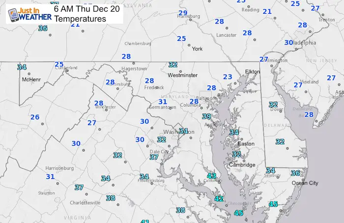
- This morning: Temps start in the 20s with thick frost.
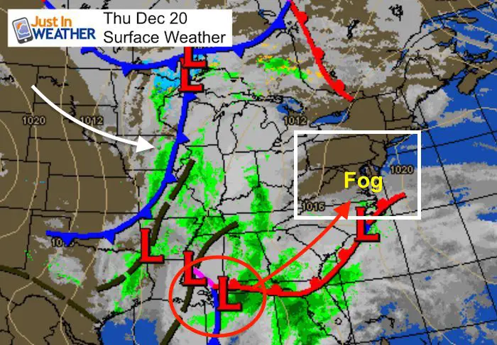
- Fog will develop ahead of the rain. Be careful early if you see fog as it could get slick on frozen pavement.
- Showers develop this morning with more steady rain afternoon.
- Heavy rain overnight into Friday morning.
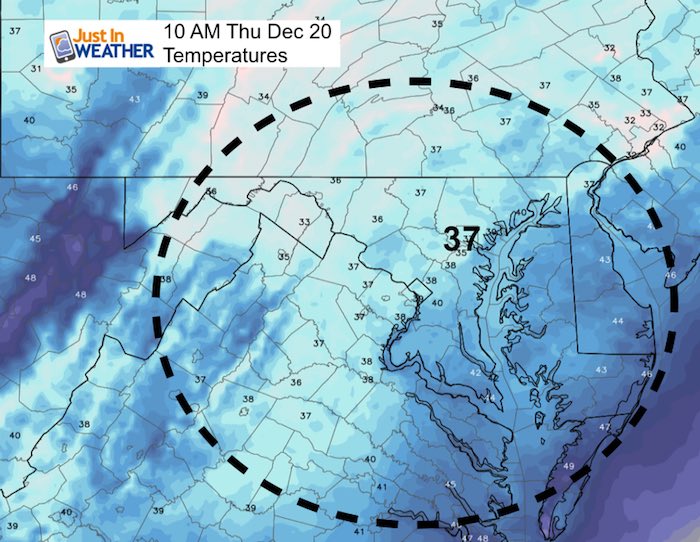
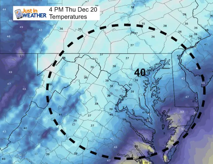
- Temperatures will be in the 30s to low 40s this afternoon.
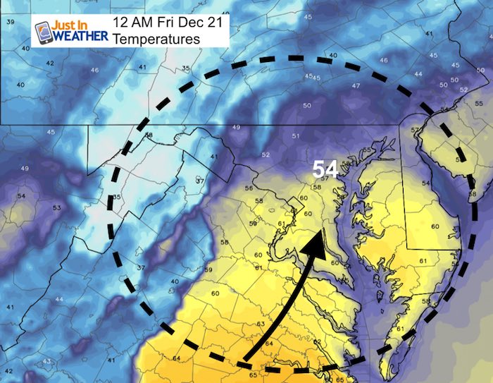
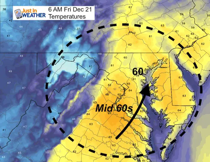
- Temperatures will reach near 60ºF tonight. Midnight to Friday morning will be the warmest time (with the heavy rain)
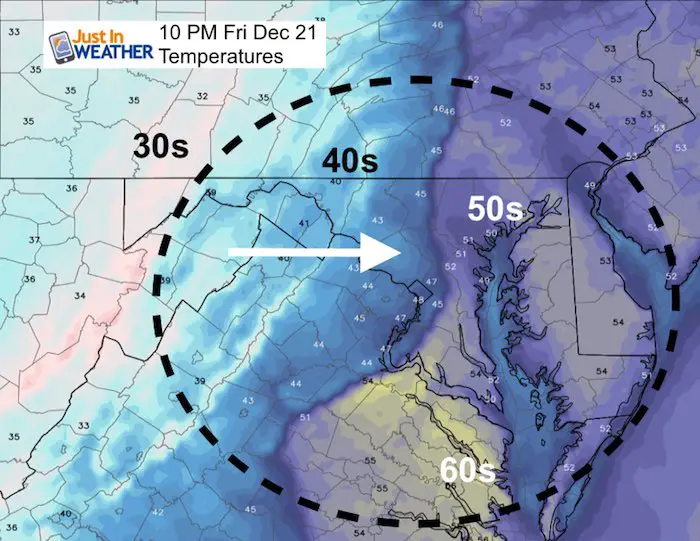
- Temperatures will fall Friday afternoon and evening.
- The storm will end with accumulating snow in the mountains Friday night
Morning Set Up
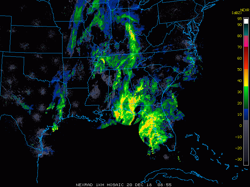
Morning Radar:
This is another large storm coming up from the Gulf of Mexico, so there is plenty of moist and it will be with us for a few days. Rain will las Friday and perhaps into Saturday morning.
Local Weather Stats For December 20 in Baltimore
The Winter Solstice is TOMORROW!
Average High: 44ºF
Record High: 67ºF in 1877
Average Low: 27ºF
Record Low: 6ºF in 1942
*Record Snow: 3.0″ in 1966
Sunrise: 7:22 AM
Sunset 4:46 PM
*Daylight = 0:07 shorter than yesterday
*Bay Water Temperature = 42ºF at Thomas Pt. Light House
Rain Timeline Thursday —> slider
[metaslider id=69838]
Temperatures
| Morning | Afternoon |
 |
 |
Midnight: Warming
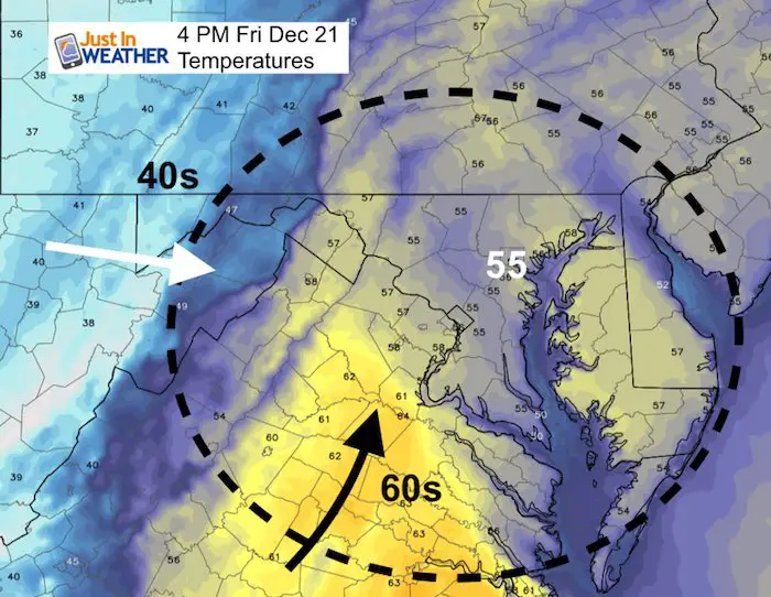
Temps will reach the 60s by Friday morning…
Friday Temperatures
Keep in mind this warm air will come with rain. The Friday rain timeline slider is below.
Rain Timeline Friday —> slider
[metaslider id=69853]
Evening
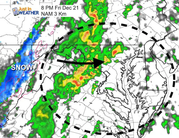
Heavy rain band and thunder possible with cold front. Snow will pile back up at Wisp, Timberline, Canaan Valley, and SnowShoe
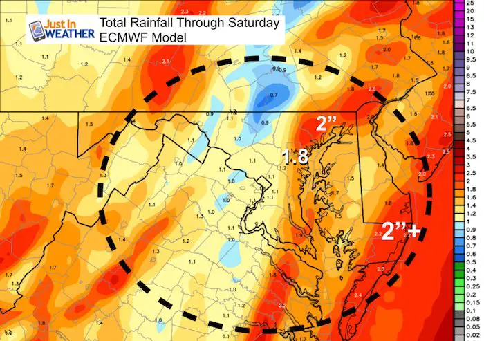
Rain Total
A wide spread of 1 to 2 inches with some pocket of higher amounts.
Storm Animation
Looking Ahead:
There is still a chance for snow or a mix early next week. There is still some confusion and disagreement on the modeling. I think how this strong storm behaves will determine what is left in its wake. I will share more on the potential Christmas Eve/Day snow or rain in my next report.
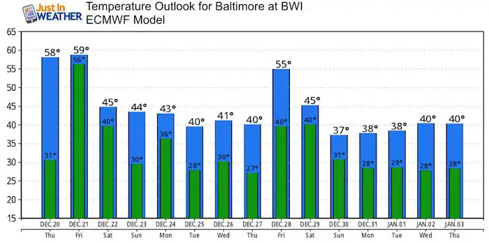
Temperature Outlook
Most of the next two weeks appears to be near or below average.
The pattern supports a storm within a few days of Jan 1 AND a much colder and snowier pattern in January.
Snow Day Kit
Our ritual the night before a storm is finally in one kit. Maybe if more Maryland kids had this, the storm would reach us 🙂
- This includes a very soft raglan Tee printed inside out with #FITF AND the check list, #FITF spoon for under your pillow, ice cube tray with snowflake shapes, chalk, a #FITF wrist-band, a mini SnowStix, and a bag to carry it all in.
- New Orders are likely to be delivered after the holiday.
- This will also help us give a free Snow Day Kit to each of the Just In Power Kids.

FITF and SnowStix Stores are now OPEN

Keep In Touch Every Day
Click here to sign up for email alerts…. Be the first to hear the big news over the weekend
Also- Just in case you don’t get the post on your social media feed
Please share your thoughts, best weather pics/video, or just keep in touch via social media
-
Facebook: Justin Berk, Meteorologist
-
Twitter: @JustinWeather
-
Instagram: justinweather
Keep In Touch Every Day
Click here to sign up for email alerts…. Just in case you don’t get the post on your social media feed
Related Links:
Winter Outlook
My Winter Outlook 2018-19: Multiple Nor’Easters and more snow

Interactive Snow Report
November 15 Snow Reports- Interactive Map Compared To My Forecast

Winter Snow And Top 5 Wet Years
Snowfall Seasons at Beginning and End of Top 5 Wet Years In Baltimore

Related Winter Outlooks
Solar Cycle: When Sun Spots Are Low We Get More Snow
El Nino Modoki May Enhance Snow Chances
Sweet Spot: Hitting 70ºF on Halloween is followed by more winter snow
Will A Wet Summer Bring A Snowy Winter?
NOAA Winter 2018-2019 Outlook Explained: This Actually Supports Snow
Winter Outlook From Two Different Farmers Almanacs
Maryland Winters: Snowfall Maps and Baltimore Snow History

Snowstix- We Need You To Measure Snow Too
We are giving 10% of each sale to Just In Power Kids: Providing FREE holistic care for pediatric oncology patients.
