 Monday December 10 2018
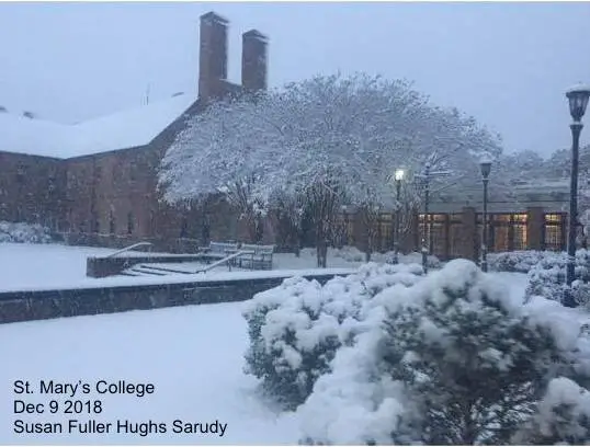
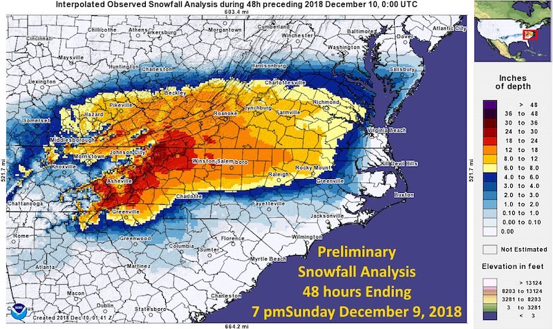
The weekend storm proved itself a force to reach into Maryland, but only the southern part with a sharp cut off line. This is the third year in a row this part of the state got an early taste of winter and it has been enough to close schools in many counties. The early report of snow posted here is not the final map. This only includes snow up to 7 PM Sunday, but it showed southern St. Mary’s County with 4 to 6 inches of snow. It will be updated later this morning.

Local Snow Spotter Reports
MARYLAND

...Anne Arundel County...
   Churchton  ENE           T   845 PM 12/09  Trained Spotter

...Calvert County...
   Drum Point 2 N         4.5   645 PM 12/09  Trained Spotter
   Lusby  ESE             3.5   745 PM 12/09  Trained Spotter
   Saint Leonard 2 NNW    3.0   739 PM 12/09  Trained Spotter
   Prince Frederick 1 S   2.0   640 PM 12/09  Trained Spotter
   Saint Leonard 2 W      1.5   718 PM 12/09  Trained Spotter
   Dunkirk 2 SSW          1.0   800 PM 12/09  Trained Spotter
   Huntingtown 2 WNW      0.8   700 PM 12/09  Trained Spotter

...Charles County...
   White Plains 2 NNE     4.5   730 PM 12/09  Trained Spotter
   Dentsville 1 SW        2.6   730 PM 12/09  Trained Spotter
   Port Tobacco Village   2.5   700 PM 12/09  CoCoRaHS
   La Plata               1.5   801 PM 12/09  Trained Spotter

...St. Marys County...
   Ridge 1 ENE            6.0  1058 PM 12/09  Trained Spotter
   Park Hall 1 NNE        5.5   800 PM 12/09  Trained Spotter
   Ridge                  5.0   801 PM 12/09  Trained Spotter
   Leonardtown            4.5  1037 PM 12/09  Dept of Highways
VIRGINIA

...Albemarle County...
   Barracks  NNE         12.1  1120 PM 12/09  Trained Spotter
   Hollymead 1 ENE       11.3   903 PM 12/09  Trained Spotter
   Woodridge 2 SW        11.0   743 PM 12/09  Trained Spotter
   Charlottesville 3 E   10.7   934 PM 12/09  Trained Spotter
   Shadwell 1 E           9.8   745 PM 12/09  Trained Spotter
   Crozet 2 E             9.6  1030 PM 12/09  Trained Spotter
   Crozet 1 W             9.5   654 PM 12/09  Public
   Woodridge 3 W          8.5   730 PM 12/09  Trained Spotter
   Hollymead 1 NNW        8.2  1030 PM 12/09  Trained Spotter
   Boyd Tavern 1 S        8.1  1150 PM 12/09  Trained Spotter

...Augusta County...
   Sherando              15.5  1025 PM 12/09  Broadcast Media
   Stuarts Draft 1 S     10.7  1100 PM 12/09  Trained Spotter
   Verona 3 SSE          10.2  1025 PM 12/09  Trained Spotter
   Hermitage 4 SW         9.5   730 PM 12/09  Trained Spotter
   Waynesboro             9.5  1125 PM 12/09  Broadcast Media
   Weyers Cave 1 SSW      5.8   800 PM 12/09  Trained Spotter

...City of Charlottesville...
   Newcomb Hall 1 SW     11.2   835 PM 12/09  Trained Spotter
   Newcomb Hall 2 SW     10.8  1050 PM 12/09  Trained Spotter
   Charlottesville 1 SE   9.5  1059 PM 12/09  Broadcast Media
   Newcomb Hall 2 SSW     9.0   900 PM 12/09  Trained Spotter
   Charlottesville 1 SS   6.5   645 PM 12/09  Trained Spotter

...City of Fredericksburg...
   Fredericksburg 1 E     4.3   620 PM 12/09  Trained Spotter

...City of Harrisonburg...
   Harrisonburg 2 W       2.8   938 PM 12/09  Broadcast Media

...City of Staunton...
   Staunton               9.5   939 PM 12/09  Broadcast Media

...City of Waynesboro...
   Waynesboro 2 WSW      10.3   958 PM 12/09  Trained Spotter
   Waynesboro 1 SSW      10.2   730 PM 12/09  Trained Spotter

...Culpeper County...
   Winston 2 NW           3.0   616 PM 12/09  Trained Spotter

...Fairfax County...
   Franconia 1 SSW          T   930 PM 12/09  Trained Spotter
School Closings
- Calvert County
- Dorchester County
- St. Mary’s College and County Schools
- Wicomico County
Morning Temperatures
Some of the snow areas in St. Mary’s are thawing. However below freezing keeping slick roads an issue on the lower Eastern Shore.

Local Weather Stats For December 10 in Baltimore
Average High: 47ºF
Record High: 72ºF in 1966
Average Low: 29ºF
Record Low: 1ºF in 1876
*Record Snow: 9.5″ in 1904
Sunrise: 7:15 AM
Sunset 4:43 PM
*Daylight = 0:44 shorter than yesterday
*Bay Water Temperature = 40ºF at Thomas Pt. Light House
Afternoon Highs

Morning: Storm Still There
Snow still hitting the mountains of North Carolina and Southern Virginia. The will wind down during the day

Outlook
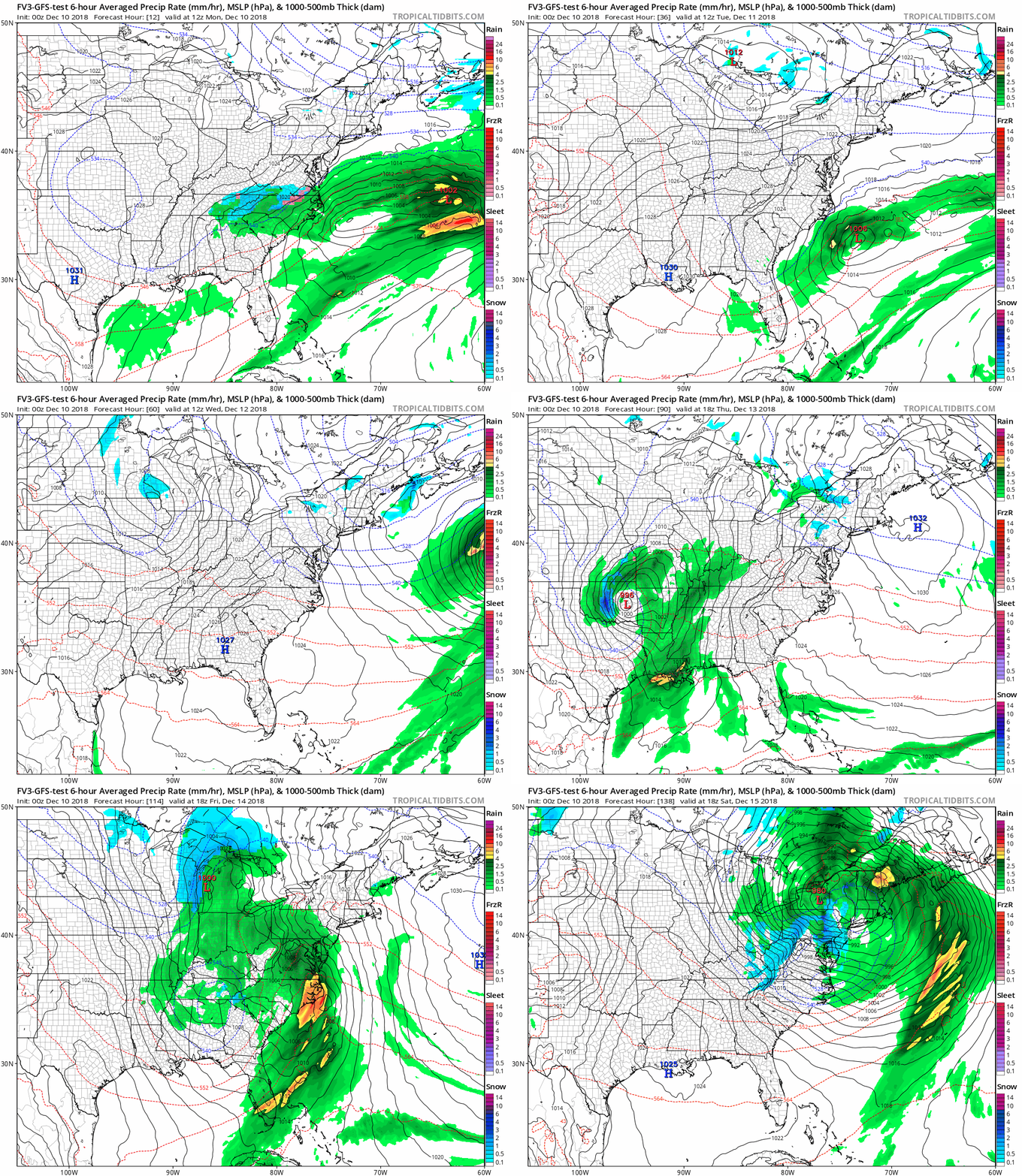
There is a small chance of flurries on Thursday, then we get in on the warmer side of the next storm. Considering possible model error like this past event… We need to consider there track may shift and the back edge of the snow might mix in snow over the weekend. That is seen on the FV3-GFS here. That was one of the best performing models with the recent event.
SnapShot

Snow Day Kit
Our ritual the night before a storm is finally in one kit. Maybe if more Maryland kids had this, the storm would reach us 🙂
- This includes a very soft raglan Tee printed inside out with #FITF AND the check list, #FITF spoon for under your pillow, ice cube tray with snowflake shapes, chalk, a #FITF wrist-band, a mini SnowStix, and a bag to carry it all in.
- This debut price is $40 off of the retail cost. Order by December 10 and it should arrive for the holiday.
- This will also help us give a free Snow Day Kit to each of the Just In Power Kids.
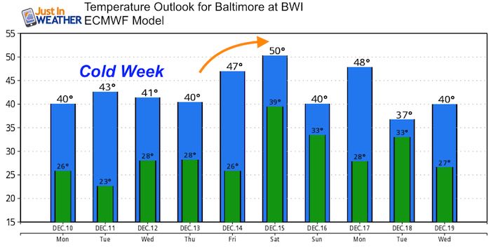
Temperature Outlook

FITF and SnowStix Stores are now OPEN
Keep In Touch Every Day
Click here to sign up for email alerts…. Be the first to hear the big news over the weekend
Also- Just in case you don’t get the post on your social media feed
Please share your thoughts, best weather pics/video, or just keep in touch via social media
-
Facebook: Justin Berk, Meteorologist
-
Twitter: @JustinWeather
-
Instagram: justinweather
Keep In Touch Every Day
Click here to sign up for email alerts…. Just in case you don’t get the post on your social media feed
Related Links:
Winter Outlook
My Winter Outlook 2018-19: Multiple Nor’Easters and more snow
Interactive Snow Report
November 15 Snow Reports- Interactive Map Compared To My Forecast
Winter Snow And Top 5 Wet Years
Snowfall Seasons at Beginning and End of Top 5 Wet Years In Baltimore
Related Winter Outlooks
Solar Cycle: When Sun Spots Are Low We Get More Snow
El Nino Modoki May Enhance Snow Chances
Sweet Spot: Hitting 70ºF on Halloween is followed by more winter snow
Will A Wet Summer Bring A Snowy Winter?
NOAA Winter 2018-2019 Outlook Explained: This Actually Supports Snow
Winter Outlook From Two Different Farmers Almanacs
Maryland Winters: Snowfall Maps and Baltimore Snow History
Snowstix- We Need You To Measure Snow Too
We are giving 10% of each sale to Just In Power Kids: Providing FREE holistic care for pediatric oncology patients.


