 December 1 2018
Today not only starts the weekend but also the beginning of meteorological winter. We group the seasons in blocks of three full months. This season starts wet with rain this afternoon and tonight, but dry and warmer Sunday. The pattern will change and we have consistency with a potential snow event next weekend. It is early, so I would take this as a chance to monitor daily, but don’t change your plans yet.
FITF – Special New Gift Idea
Before we get started today, I wanted to share something new: There was a lot of activity over the holiday weekend that I wanted offer the most popular combo as a gift idea. These Tees and hats go perfectly together, and grouping then will be discounted:

Local Weather Stats For December 1 in Baltimore
Climatological cooling shows we lose one degree on the high every two to three days this month.
Average High: 50ºF
Record High: 75ºF in 2006
Average Low: 32ºF
Record Low: 12ºF in 1967
*Record Snow: 1.5″ in 1903
Sunrise: 7:07 AM
Sunset 4:43 PM
*Daylight = 1:13 shorter than yesterday
*Bay Water Temperature = 45ºF at Thomas Pt. Light House
Record Rain Year Update:
The rain on Monday was 0.42″ at BWI. Considering the storm on the way this weekend and one month left in 2018, we may make a run for 70 inches.

Morning Snapshot

Rain Timeline –> slider
- Rain showers will develop this afternoon. It will not be a washout, but you may get a cluster of a few hours at a time with rain.
- Steady rain is likely overnight.
- Total rain under 1/2 inch expected
[metaslider id=69106]
Sunday Morning
After a rainy night, we should begin to dry out around daybreak

Sunday Afternoon
It will be mild, but the NAM 3 Km Model is showing a slower climb up on the thermometer. There is a chance for 60s in central Maryland, but more likely in southern Maryland and Virginia.

Looking Ahead
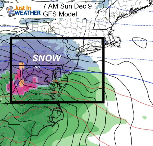
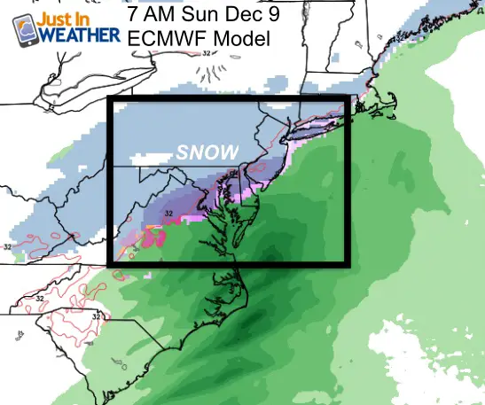
Colder air will spill in mid week, but our chance of snow for December 5th has faded. However, there is consistency with a storm next weekend. This shows up on both the GFS Model and European ECMWF Models.
 |
 |
GFS Model Storm Animation
Friday Night through Sunday Night

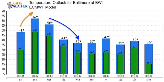
Temperature Outlook
North Atlantic Oscillation

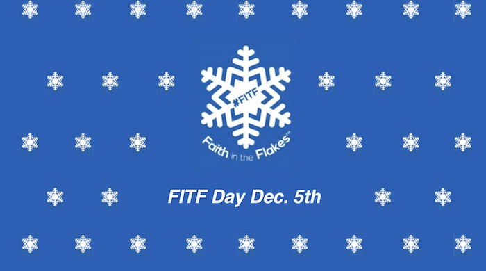
December 5th- FITF Day
Gather your friends and co-workers: Wear your #FITF gear to honor and celebrate this unique calendar holiday. This is the date almost every day last decade marked the first snow of each winter season. I will have the history to show shortly.
FITF and SnowStix Stores are now OPEN

Keep In Touch Every Day
Click here to sign up for email alerts…. Be the first to hear the big news over the weekend
Also- Just in case you don’t get the post on your social media feed
Please share your thoughts, best weather pics/video, or just keep in touch via social media
-
Facebook: Justin Berk, Meteorologist
-
Twitter: @JustinWeather
-
Instagram: justinweather
Keep In Touch Every Day
Click here to sign up for email alerts…. Just in case you don’t get the post on your social media feed
Related Links:
Winter Outlook
My Winter Outlook 2018-19: Multiple Nor’Easters and more snow

Interactive Snow Report
November 15 Snow Reports- Interactive Map Compared To My Forecast

Winter Snow And Top 5 Wet Years
Snowfall Seasons at Beginning and End of Top 5 Wet Years In Baltimore

Related Winter Outlooks
Solar Cycle: When Sun Spots Are Low We Get More Snow
El Nino Modoki May Enhance Snow Chances
Sweet Spot: Hitting 70ºF on Halloween is followed by more winter snow
Will A Wet Summer Bring A Snowy Winter?
NOAA Winter 2018-2019 Outlook Explained: This Actually Supports Snow
Winter Outlook From Two Different Farmers Almanacs
Maryland Winters: Snowfall Maps and Baltimore Snow History

Snowstix- We Need You To Measure Snow Too
We are giving 10% of each sale to Just In Power Kids: Providing FREE holistic care for pediatric oncology patients.
