Friday November 30 2018
This is the last day of November, which ends hurricane season and meteorological fall. Winter begins in the meteorological community on December 1, but it will take few days to get the cold pattern back in place. In the meantime, we will get rain and then a big warm up that will make you want to spend the end of the weekend outside.
If we want cold air and snow, just hang on a little longer. Colder air will settle back in place with an active pattern. There is plenty of time for it to link up. While the pattern change is expected mid week, it might be next weekend with a better chance for a winter storm. FITF
Local Weather Stats For November 30 in Baltimore
Average High: 51ºF
Record High: 74ºF in 1933
Average Low: 32ºF
Record Low: 12ºF in 1929
*Record Snow: 8.4″ in 1967
Sunrise: 7:06 AM
Sunset 4:43 PM
*Daylight = 1:17 shorter than yesterday
*Bay Water Temperature = 45ºF at Thomas Pt. Light House
Record Rain Year Update:
The rain on Monday was 0.42″ at BWI. Considering the storm on the way this weekend and one month left in 2018, we may make a run for 70 inches.

The FITF Store Is Open With Gear And SnowStix
A portion of all proceeds for FITF and SnowStix goes to our nonprofit Just In Power Kids- providing FREE holistic care for kids in and post cancer treatment.
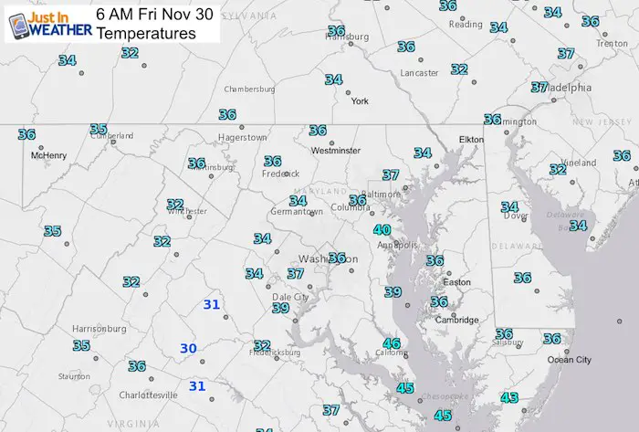
Morning Snapshot
Rain Timeline Today —> slider
[metaslider id=69007]
High Temperatures Today

Rain Timeline Saturday/Sunday —> slider
[metaslider id=69026]
High Temperatures Sunday
The rain should be over when you wake up… This will be the day to get outside.

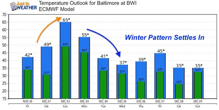
Looking Ahead: Temperatures And Chance For Snow
Temperature Outlook
After a mild Sunday, the weather pattern will shift to lock in the cold next week.
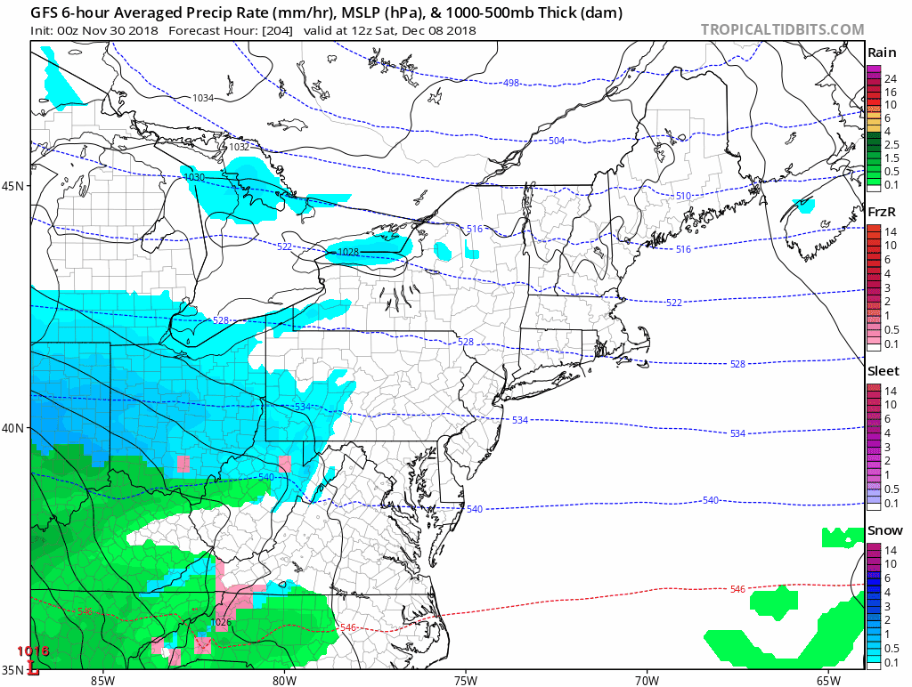
December 5th Snow- Losing Support
This event appears to stay south on the GFS, but the European Model faded it to only flurries at best. Sometimes the modeling loses energy that shows up a few days later with more support.

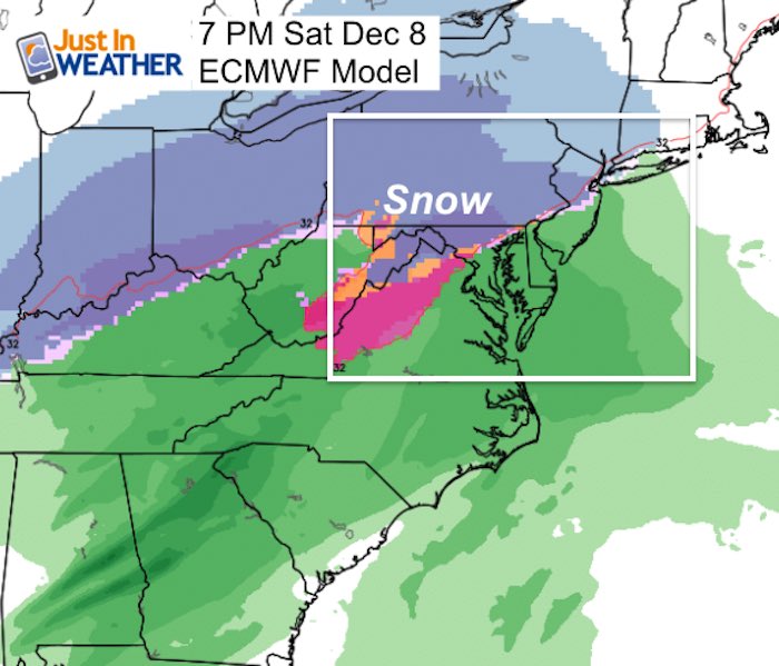
Next Weekend Storm?
I do not like to show weather specifics more than 1 week away, but since the December 5th event seems thin, the European and GFS Models link the energy up and try to produce a winter storm next weekend
 |
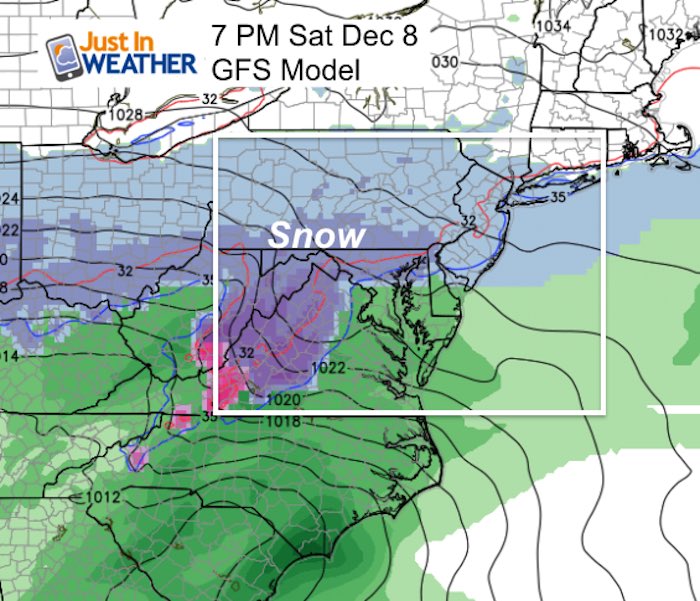 |
Storm Animation Next Weekend
FITF
December 5th- FITF Day
Gather your friends and co-workers: Wear your #FITF gear to honor and celebrate this unique calendar holiday. This is the date almost every day last decade marked the first snow of each winter season. I will have the history to show shortly.
FITF and SnowStix Stores are now OPEN

Keep In Touch Every Day
Click here to sign up for email alerts…. Be the first to hear the big news over the weekend
Also- Just in case you don’t get the post on your social media feed
Please share your thoughts, best weather pics/video, or just keep in touch via social media
-
Facebook: Justin Berk, Meteorologist
-
Twitter: @JustinWeather
-
Instagram: justinweather
Keep In Touch Every Day
Click here to sign up for email alerts…. Just in case you don’t get the post on your social media feed
Related Links:
Winter Outlook
My Winter Outlook 2018-19: Multiple Nor’Easters and more snow

Interactive Snow Report
November 15 Snow Reports- Interactive Map Compared To My Forecast

Winter Snow And Top 5 Wet Years
Snowfall Seasons at Beginning and End of Top 5 Wet Years In Baltimore

Related Winter Outlooks
Solar Cycle: When Sun Spots Are Low We Get More Snow
El Nino Modoki May Enhance Snow Chances
Sweet Spot: Hitting 70ºF on Halloween is followed by more winter snow
Will A Wet Summer Bring A Snowy Winter?
NOAA Winter 2018-2019 Outlook Explained: This Actually Supports Snow
Winter Outlook From Two Different Farmers Almanacs
Maryland Winters: Snowfall Maps and Baltimore Snow History

Snowstix- We Need You To Measure Snow Too
We are giving 10% of each sale to Just In Power Kids: Providing FREE holistic care for pediatric oncology patients.
