Wednesday November 21 2019
This big travel day before Thanksgiving may have some travel concern if you are heading north to Pennsylvania or New York. The near record cold air we’ve discussed on the way will have a strong arctic front to bring it in. This really looks like a mid winter pattern and it will look like it in some areas. Track the line of snow squalls this afternoon below.
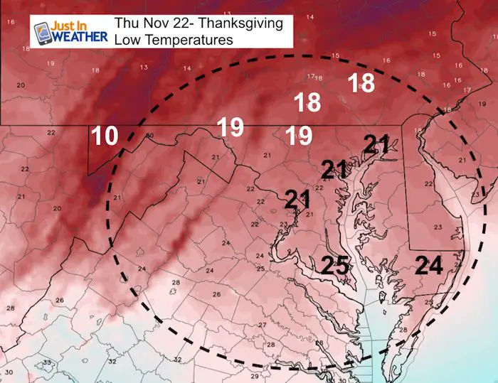
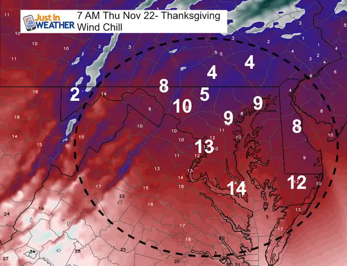
Thanksgiving Day will be painful cold, especially if you are doing a Turkey Trot in the morning. Temperatures and wind chills below. The good thing is that it will keep many indoors and hopefully force families together to reconnect.
Next up will be the frigid Thanksgiving and then a weekend storm that may start with freezing rain. That might explain why some counties have those pretreated lines down on the pavement. This showed up on Frederick roads yesterday. Tina Cline was surprised along with many of her friends. I can only imagine it was one before the holiday expecting it to stay on the roads for the weekend, when it might be more expensive to bring in the same personal todo the job???
Local Weather Stats For November 21 in Baltimore
Average High: 54ºF
Record High: 79ºF in 1900
Average Low: 35ºF
Record Low: 16ºF in 1951
*Record Snow: Trace in 2008
Sunrise: 6:56 AM
Sunset 4:47 PM
*Daylight = 1:41 shorter than yesterday
*Bay Water Temperature = 49ºF at Thomas Pt. Light House
Also See: Smoke from CA Fires Reached The East Coast
Just In: #FITF Hats

Keep In Touch Every Day
Click here to sign up for email alerts…. Just in case you don’t get the post on your social media feed
The FITF Store Is Open With Gear And SnowStix
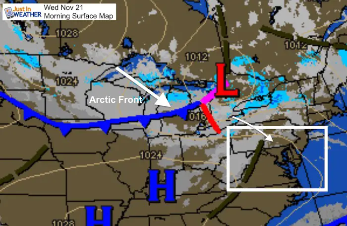
Morning Snapshot
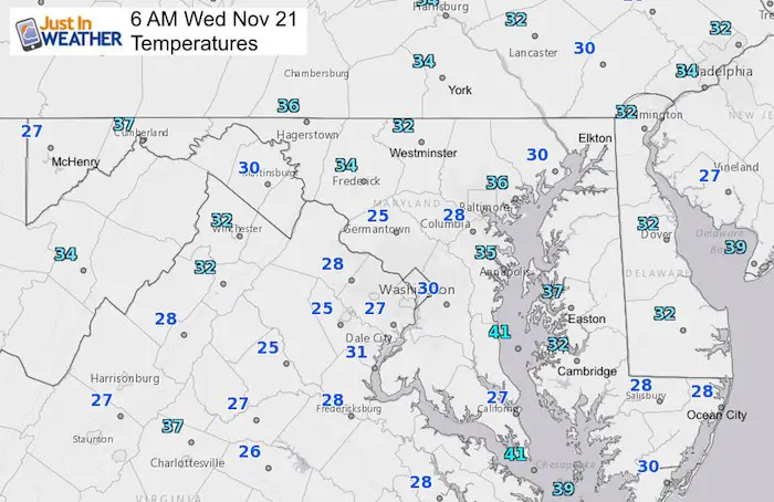
Temperatures
Arctic Front –> slider
Snow with the front will reach central PA around 3 PM. It should break apart, but some flurries may fall around Harrisburg, York, Lancaster, and maybe northern Maryland. The real cold air arrives this evening.
[metaslider id=68689]
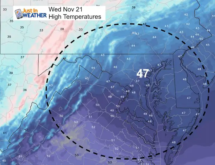
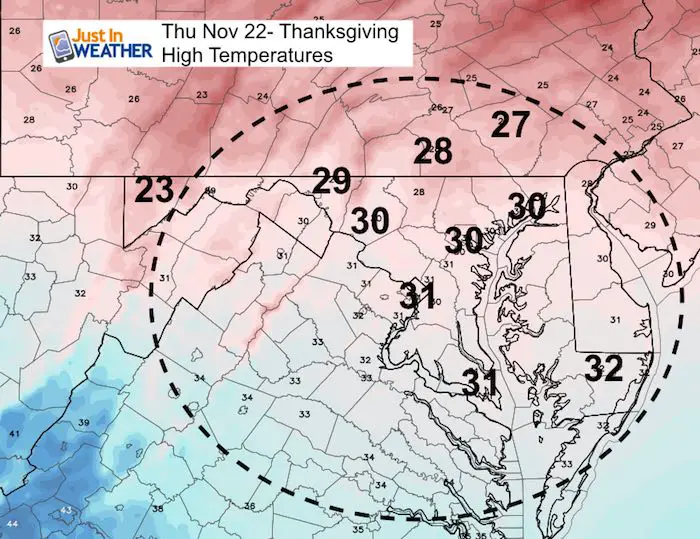
Afternoon Highs
Thanksgiving – Morning
What it will FEEL LIKE
Thanksgiving Afternoon
The record COLDEST MAX TEMPERATURE for Baltimore on November 22:
28ºF set in 1880
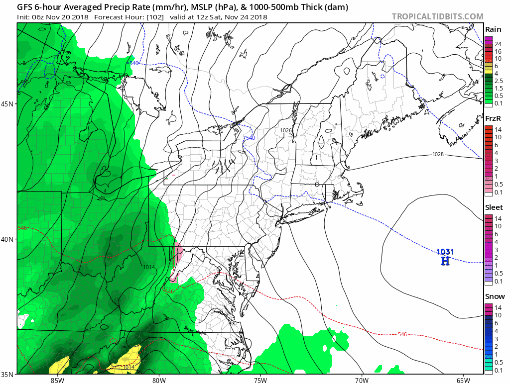
Storm Animation
Rain arrives Saturday… It may begin with sleet in the mountains. Then turn heavy by evening. The next system next will will reinforce the cold winter like patten
Outlook
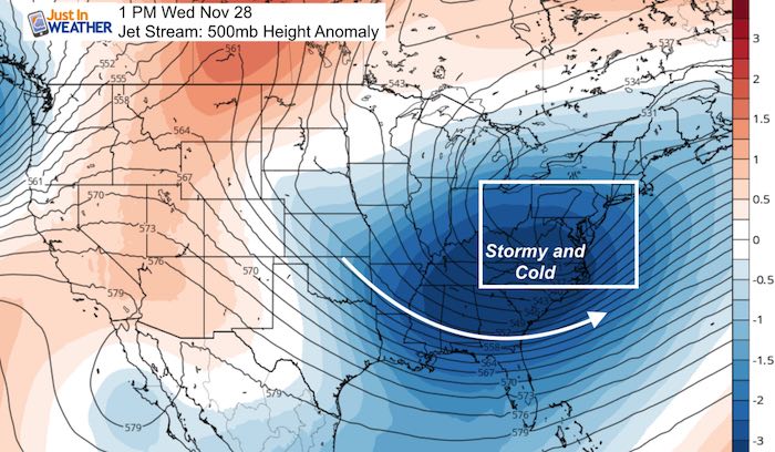
Storm Pattern
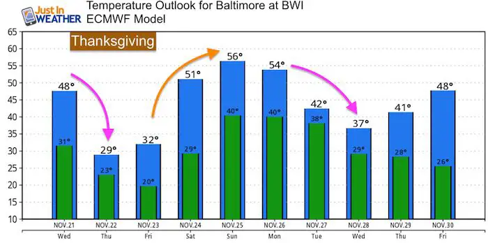
Temperatures
There may be a brief warm up by November 30, but the pattern will lock in with the very cold air during the start of December. Look for a few storms during the first 10 days of December.
Please share your thoughts, best weather pics/video, or just keep in touch via social media
-
Facebook: Justin Berk, Meteorologist
-
Twitter: @JustinWeather
-
Instagram: justinweather
Keep In Touch Every Day
Click here to sign up for email alerts…. Just in case you don’t get the post on your social media feed
The FITF Store Is Open With Gear And SnowStix
Related Links:
Winter Outlook
My Winter Outlook 2018-19: Multiple Nor’Easters and more snow

Interactive Snow Report
November 15 Snow Reports- Interactive Map Compared To My Forecast

Winter Snow And Top 5 Wet Years
Snowfall Seasons at Beginning and End of Top 5 Wet Years In Baltimore

Related Winter Outlooks
Solar Cycle: When Sun Spots Are Low We Get More Snow
El Nino Modoki May Enhance Snow Chances
Sweet Spot: Hitting 70ºF on Halloween is followed by more winter snow
Will A Wet Summer Bring A Snowy Winter?
NOAA Winter 2018-2019 Outlook Explained: This Actually Supports Snow
Winter Outlook From Two Different Farmers Almanacs
Maryland Winters: Snowfall Maps and Baltimore Snow History

Snowstix- We Need You To Measure Snow Too
We are giving 10% of each sale to Just In Power Kids: Providing FREE holistic care for pediatric oncology patients.
