Tuesday November 20 2018
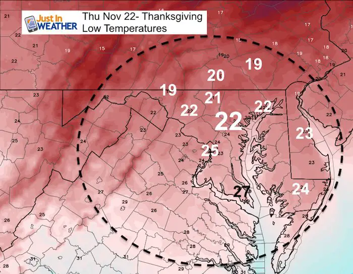
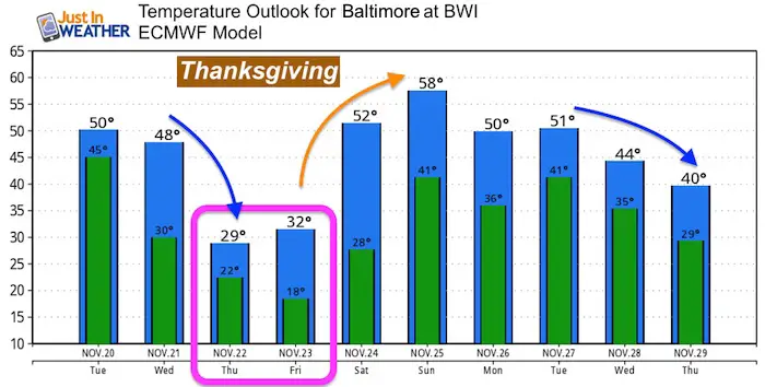
A few showers moved through this morning that may help the air quality, but will make the beginning of the cold air intrusion. Snow showers will prevail in western Maryland for the day. Region-wide, a legitimate winter pattern is building for Thanksgiving that will make it feel more like Christmas. If you and your family have plans for a Turkey Trot on Thanksgiving morning, you will want to dig out the winter clothing. It is going to be brutally cold and might be a shock to your system.
Over the holiday weekend we expect a warm up with rain on Saturday. The following week does continue to show the pattern shifting back to cold air and looking stormy into December. Here is the latest.
Local Weather Stats For November 20 in Baltimore
Average High: 55ºF
Record High: 79ºF in 1942
Average Low: 56ºF
Record Low: 22ºF in 1954
*Record Snow: 2.1″ in 1961
Sunrise: 6:55AM
Sunset 4:48 PM
*Daylight = 1:43 shorter than yesterday
*Bay Water Temperature = 50ºF at Thomas Pt. Light House
Also See: Smoke from CA Fires Reached The East Coast
Just In: #FITF Hats

Keep In Touch Every Day
Click here to sign up for email alerts…. Just in case you don’t get the post on your social media feed
The FITF Store Is Open With Gear And SnowStix
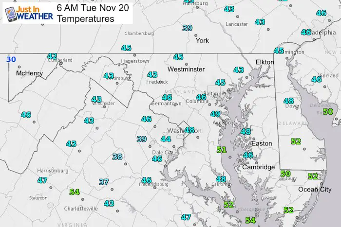
Morning Snapshot
Temperatures
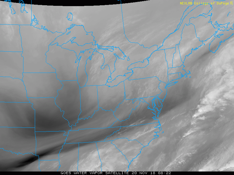
Satellite Loop
Afternoon
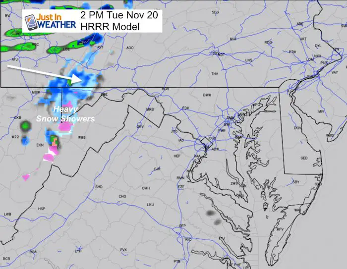
Temperatures
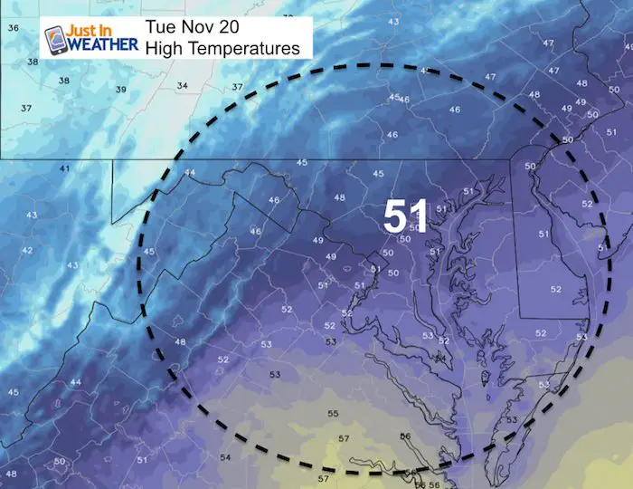
Temperatures Trending Colder
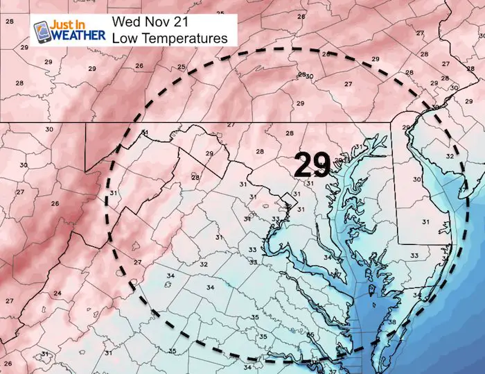
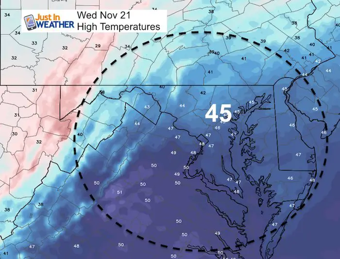
Wednesday
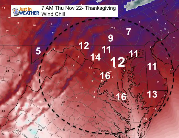
Thanksgiving Morning
These are morning temps, but the afternoon is likely to remain below freezing.
Low Temperatures
Wind Chills
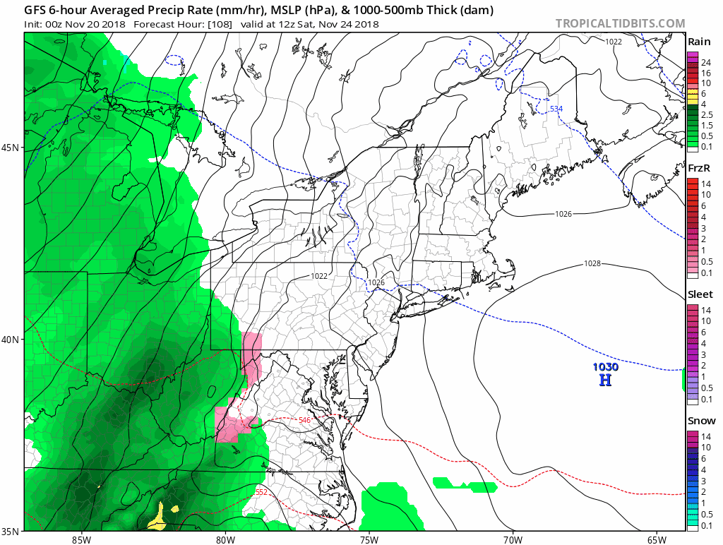
Holiday Weekend Weather
Rain Saturday ends Sunday morning.
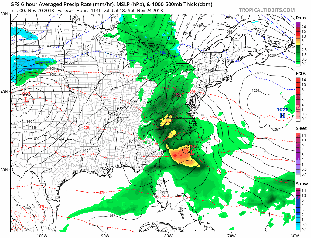
Stormy Trend:
The next storm will be Monday Nov 26, with rain, that will mark the pattern change … Watch the snow expand to our north.
Temperature Outlook
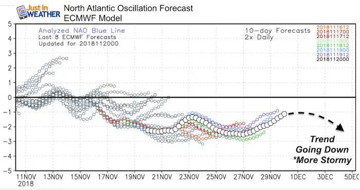
Long Range Outlook
The NAO will remain negative. While this outlook only takes us through the end of November, the trend will drop lower into the start of December.
Early December Will Be Stormy
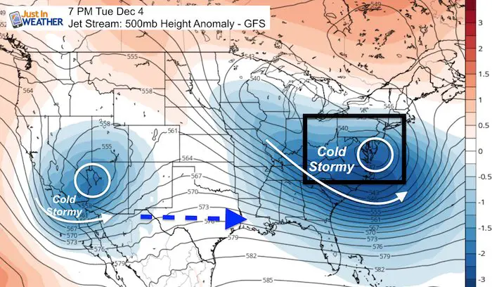
The phasing event for early December has been a consistent showing.. But I will NOT lock in on rain or snow. The surface features are less accurate to call now. But, we can see another southern California storm that will track across the southern US to follow this one with even colder air in place.
Please share your thoughts, best weather pics/video, or just keep in touch via social media
-
Facebook: Justin Berk, Meteorologist
-
Twitter: @JustinWeather
-
Instagram: justinweather
Keep In Touch Every Day
Click here to sign up for email alerts…. Just in case you don’t get the post on your social media feed
The FITF Store Is Open With Gear And SnowStix
Related Links:
Winter Outlook
My Winter Outlook 2018-19: Multiple Nor’Easters and more snow

Interactive Snow Report
November 15 Snow Reports- Interactive Map Compared To My Forecast

Winter Snow And Top 5 Wet Years
Snowfall Seasons at Beginning and End of Top 5 Wet Years In Baltimore

Related Winter Outlooks
Solar Cycle: When Sun Spots Are Low We Get More Snow
El Nino Modoki May Enhance Snow Chances
Sweet Spot: Hitting 70ºF on Halloween is followed by more winter snow
Will A Wet Summer Bring A Snowy Winter?
NOAA Winter 2018-2019 Outlook Explained: This Actually Supports Snow
Winter Outlook From Two Different Farmers Almanacs
Maryland Winters: Snowfall Maps and Baltimore Snow History

Snowstix- We Need You To Measure Snow Too
We are giving 10% of each sale to Just In Power Kids: Providing FREE holistic care for pediatric oncology patients.
