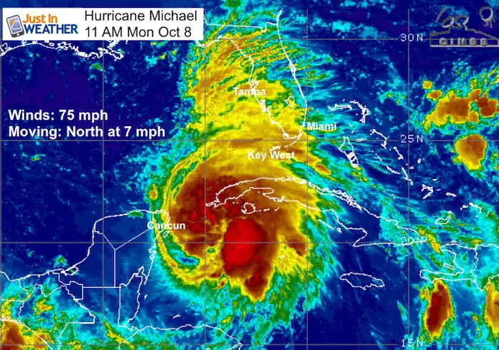
Monday October 8 2018
Michael is now the 7th storm in the Atlantic Basin this year to reach hurricane intensity. Winds are 75 mph and it is moving to the north at 7 mph. It is located between Mexico’s Yucatan Peninsula and western Cuba, but on a path to Florida. The warm water and improved environment for development should allow this to at least reach Category 2 intensity before making landfall on the Florida panhandle.
New Hurricane Watch for Florida from Alabama border to Suwannee River. Storm Surge Watch from Navarra to Anna Maria Island in Florida. See the complete list of watches and warnings below.
SUMMARY OF WATCHES AND WARNINGS IN EFFECT:
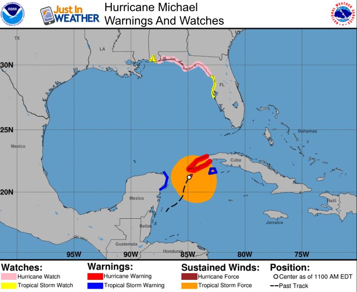 A Hurricane Warning is in effect for...
* The Cuban province of Pinar del Rio
A Tropical Storm Warning is in effect for...
* The Cuban province of the Isle of Youth
* The coast of Mexico from Tulum to Cabo Catoche, including Cozumel
A Storm Surge Watch is in effect for...
* Navarre Florida to Anna Maria Island Florida, including Tampa Bay Peak storm surge on Florida's Big Bend
could be 7 to 11 Ft
A Hurricane Watch is in effect for...
* Alabama-Florida border to Suwannee River Florida
A Tropical Storm Watch is in effect for...
* Suwannee River to Anna Maria Island Florida, including Tampa Bay
* Alabama-Florida border to the Mississippi-Alabama border
A Hurricane Warning is in effect for...
* The Cuban province of Pinar del Rio
A Tropical Storm Warning is in effect for...
* The Cuban province of the Isle of Youth
* The coast of Mexico from Tulum to Cabo Catoche, including Cozumel
A Storm Surge Watch is in effect for...
* Navarre Florida to Anna Maria Island Florida, including Tampa Bay Peak storm surge on Florida's Big Bend
could be 7 to 11 Ft
A Hurricane Watch is in effect for...
* Alabama-Florida border to Suwannee River Florida
A Tropical Storm Watch is in effect for...
* Suwannee River to Anna Maria Island Florida, including Tampa Bay
* Alabama-Florida border to the Mississippi-Alabama border
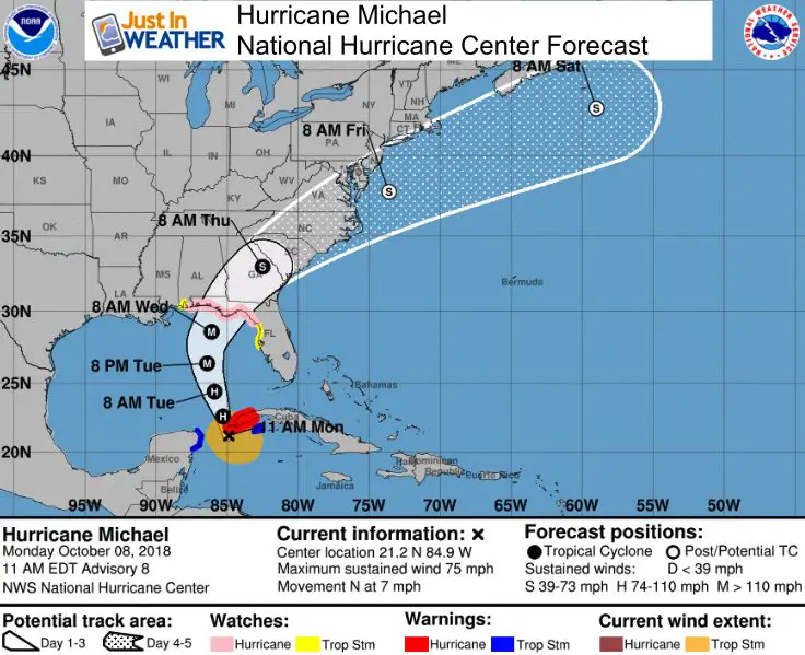
Michael will speed up as it moves north. It will cross Georgia into South and North Carolina across some of the same regions that are still flooded form Florence. The good new is that this will speed up and move away in a hurry.
The path curves across southeast Virginia and might get the core Low as a Tropical Storm or Depression near Salisbury and Ocean City Maryland late Thursday into Friday.
What does this mean for us (Mid Atlantic)?
- In the Mid Atlantic region, our wet day will be Thursday. The core Low should be off of the coast Friday morning.
- Michael plus cold front will spread heavy rain and possible severe thunderstorms.
- Isolated tornadoes near the core Low route.
- Where the heavy rain falls is still up for debate. See the model comparison below…
- Pattern Change: Colder air will spill in behind Michael and make it feel more like Fall this weekend.
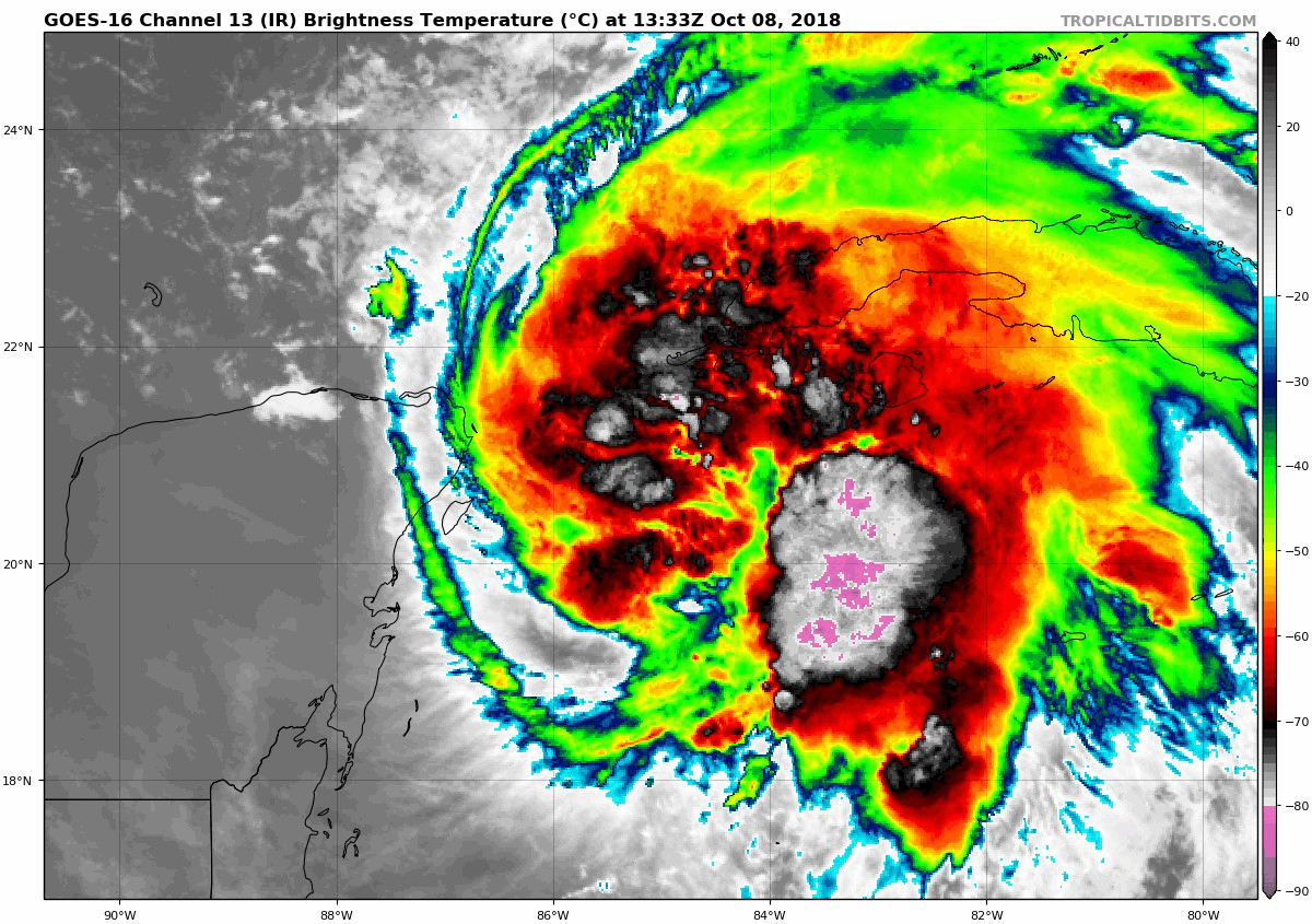
Satellite Loops This Morning
The visible satellite shows the explosive high cloud tops
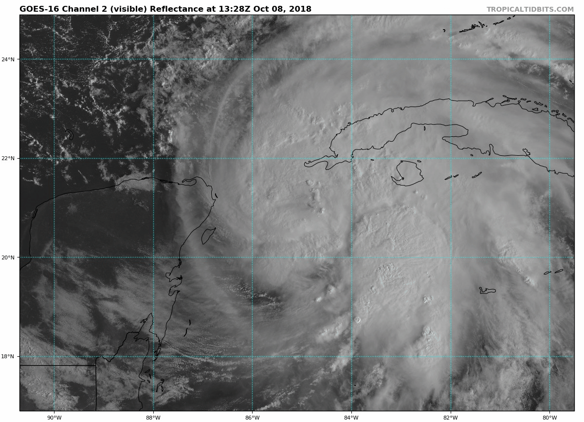
The enhanced infrared satellite shows the colder loud tips in shades of grey and purple. The organization around the center is a signal that this is ripe for further rapid development. I would expect the best development after it clears Cuba and fully enters the Gulf of Mexico.
Forecast Model Plots
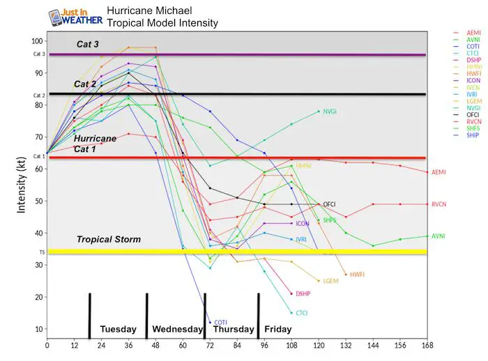
Intensity
Agreement that this will reach Category 2 intensity overnight or Tuesday. Chance to reach Category 3 is just under 20%.
Track
Good agreement that this will make landfall between Pensacola and Panama City Florida on Wednesday.
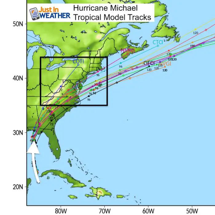
Animation
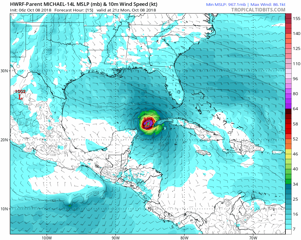
HWRF Model
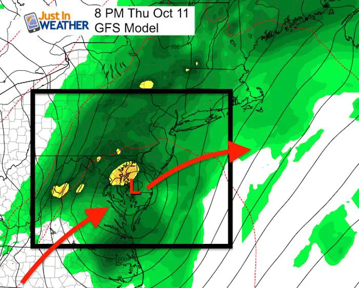
How Much Rain?
This is the low confident part of the forecast because it depends on:
- Cold Front
- Track/Timing of Michael
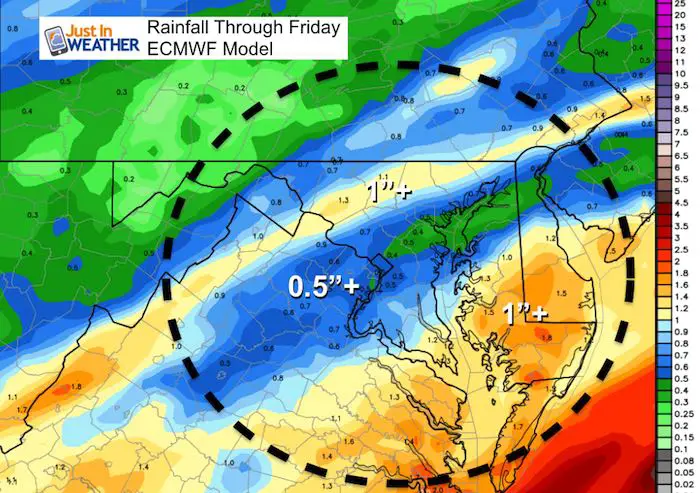
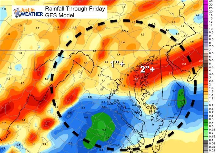
Here is a comparisons of the GFS and ECMWF (European) Models. Notice the split in the heavy rain in the ECMWF. The 1″+ rain band north of Baltimore is with the cold front. The next heavy rain zone is southern Maryland and Delmarva. But the GFS Model is farther north with the track and pushed the rain zone merging with the front across central Maryland with over 2 inches… The over 1 inch spread is a much wider area into Pennsylvania.
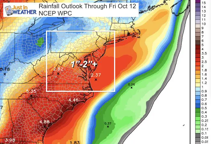
NOAA Forecast
This keeps the heaviest of the rain south of Baltimore.
National Hurricane Center Forecast Track
Keep In Touch Every Day
Click here to sign up for email alerts…. Just in case you don’t get the post on your social media feed
Please share your thoughts, best weather pics/video, or just keep in touch via social media
-
Facebook: Justin Berk, Meteorologist
-
Twitter: @JustinWeather
-
Instagram: justinweather
Love Maryland Shirt Designed By Jaiden
 |
|
This shirt was designed by my ‘bonus’ daughter Jaiden. All proceeds will go to Just In Power Kids and free holistic therapy for kids in and post cancer treatment.
Show your love for Maryland and make this 14 year old artist extra proud
|
![]()
 Get the award winning Kid Weather App I made with my oldest son and support our love for science, weather, and technology. Our 3 year anniversary of the release and our contribution to STEM education is this November. It has been downloaded in 60 countries, and works in both temperature scales. With your support we can expand on the fun introduction to science and real weather.