 12:00 PM Wednesday September 12 2018
Here is a quick view of the satellite loop this morning showing a vivid signal that Hurricane Florence will slow down. It may take two days to drift to the southwest along the North and South Carolina Coast before heading inland. That would extend the worst part of the storms impact for a larger area of coastline. But the same force ding this is what will likely improve the weather across Maryland, Pennsylvania, and much of Virginia this weekend.
The models are a little slow this morning due to the extra resources studying Hurricane Florence. I will have another update on the forecast track in a few hours.
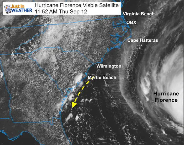
Close Visible Satellite Loop
The outer cirrus band of Florence is just about the reach Cape Hatteras.
Watch the clouds develop along the South Carolina coast and flow southwest along the coast. This is a signal of the local winds flowing from the north to south that will interact with Florence.
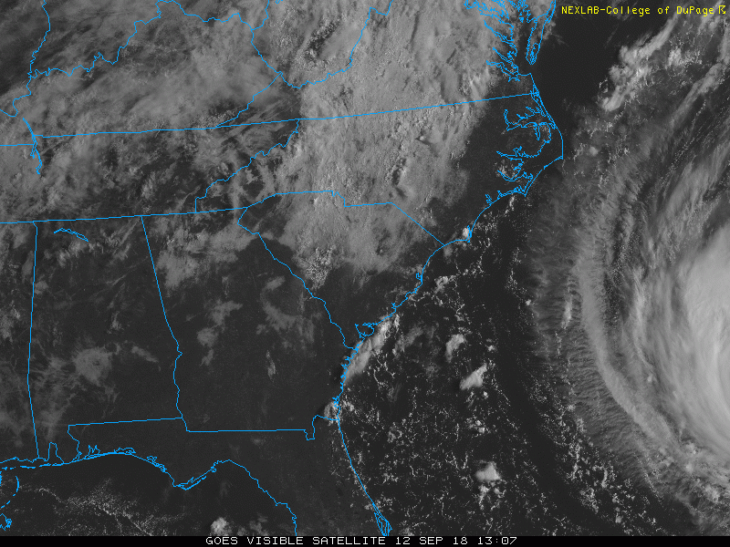
Wide Satellite Loop
The eye of Florence can easily be seen here moving to the west northwest.
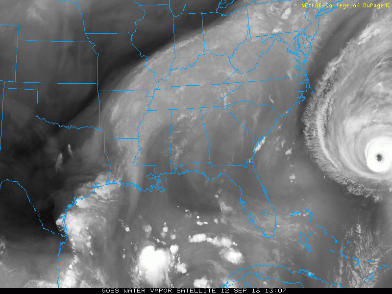
Look at the clouds in Tennessee, Kentucky, and North Carolina. The movement is to the north and northeast, then dropping south in central North and South Carolina.
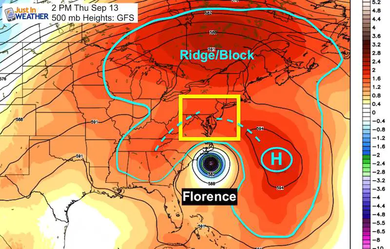
Steering Aloft
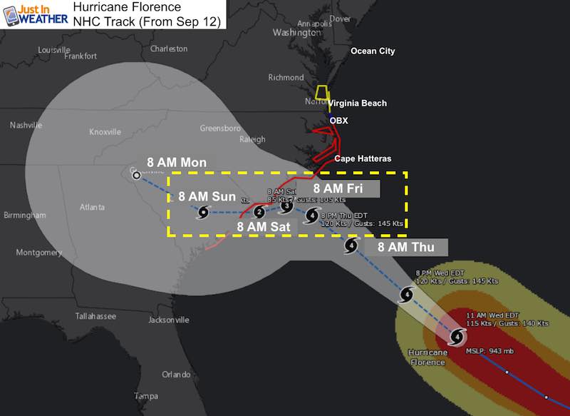
This is the 500 mb Height Map (around 18,000 Ft). On Thursday afternoon this shows the High Pressure in the Atlantic helping to push Florence onshore. But a larger ridge to the north is the blocking that will prevent it from turning up the coast…. and allowing our region in the Mid Atlantic and New England to have a nice weekend.
But the ridge extends down the Appalachians into Georgia. That is why this storm will nearly stall or crawl.
Latest NOAA Forecast Map
This shows the adjustment that the European Model first showed yesterday. The HWRF and GFS all support this as well… but the actually location of the stall and speed or drifting is still up for debate.
The main idea is that Florence could crawl along the coast between Friday morning and move onshore Sunday morning. That would be 48 hours between Category 2 and 4 intensity.
Click here to see the full morning report
Notes:
- It is important to consider that the strongest side of this storm will on the north end with wind and waves pushing onshore.
- If the storm stalls, then upwelling will churn colder water from below and could help weaken the storm
- Interacting with land brings in dry air into the storm and helps it weaken
- When onshore the storm will weaken but can take days to dump out heavy rain
- There is a chance the circulation swings back our way next week.
Storm Alerts
Flood problems on the coast include heavy rain falling down plus water rising up with storm surge up 9 to 13 feet.
Winds today are 130 mph gusting to 160 mph. Even if this increases, winds will likely weaken as the storm approaches land.
Hurricane Force Winds reach 70 miles from the center
Tropical Storm Force Winds reach 175 miles from the center
Watches and Warnings
A Storm Surge Warning is in effect for...
* South Santee River South Carolina to Duck North Carolina
* Albemarle and Pamlico Sounds, including the Neuse and Pamlico
Rivers

A Storm Surge Watch is in effect for...
* Edisto Beach South Carolina to South Santee River South Carolina
* North of Duck North Carolina to the North Carolina/Virginia border

A Hurricane Warning is in effect for...
* South Santee River South Carolina to Duck North Carolina
* Albemarle and Pamlico Sounds

A Hurricane Watch is in effect for...
* Edisto Beach South Carolina to South Santee River South Carolina

A Tropical Storm Warning is in effect for...
* North of Duck North Carolina to the North Carolina/Virginia border

A Tropical Storm Watch is in effect for...
* North of the North Carolina/Virginia border to Cape Charles Light
Virginia
* Chesapeake Bay south of New Point Comfort
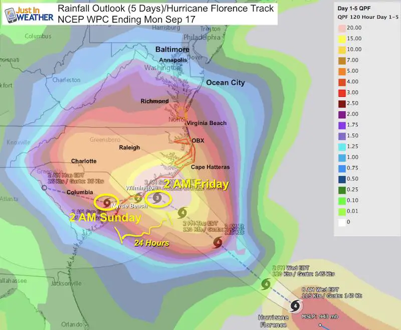
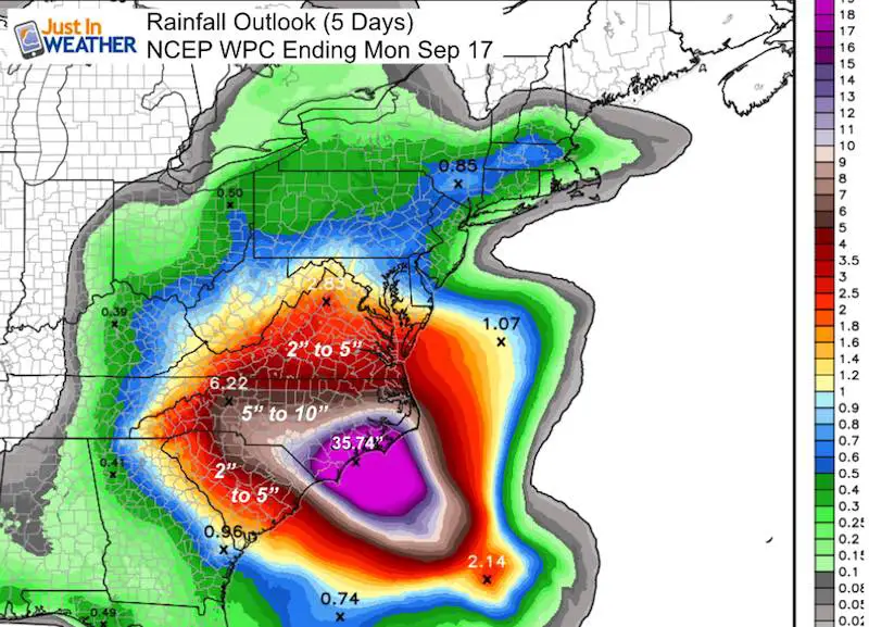
Rainfall Expectation
The rainfall expectation will peak along the path. But the northern edge shown on these maps is not all from Florence. There have been showers with the old front that may have been misleading in parts of Maryland and Pennsylvania.
Total Rain
May exceed 3 feet in parts of coastal North Carolina. This is in addition to storm surge and wind damage.
Keep In Touch Every Day
Click here to sign up for email alerts…. Just in case you don’t get the post on your social media feed
Please share your thoughts, best weather pics/video, or just keep in touch via social media
-
Facebook: Justin Berk, Meteorologist
-
Twitter: @JustinWeather
-
Instagram: justinweather
Love Maryland Shirt Designed By Jaiden
 |
|
This shirt was designed by my ‘bonus’ daughter Jaiden. All proceeds will go to Just In Power Kids and free holistic therapy for kids in and post cancer treatment.
Show your love for Maryland and make this 14 year old artist extra proud
|
Now Scheduling School Assemblies
- Storm Smart – Severe Weather (September, October; March through May)
- FITF – Snow and ice (November through March)
Programs for K through Middle School
Choose flat fee or FREE along with a spirit wear shirt fundraiser that earns your school money.
Power Partner Just In Power Kids and Maryland Trek 5:

Still Time To Support Just In Power Kids
We are still taking donations for our best Maryland Trek yet. Every penny goes to Just In Power Kids programs to provide FREE holistic care for kids in cancer treatment and up to 5 years post treatment.
![]()
 Get the award winning Kid Weather App I made with my oldest son and support our love for science, weather, and technology. Our 3 year anniversary of the release and our contribution to STEM education is this November. It has been downloaded in 60 countries, and works in both temperature scales. With your support we can expand on the fun introduction to science and real weather.