 Wednesday September 12 2018
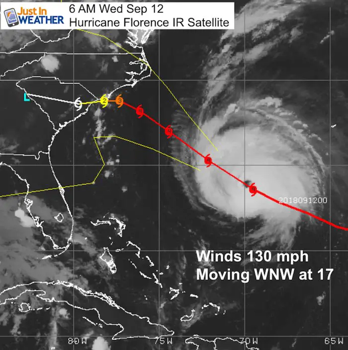
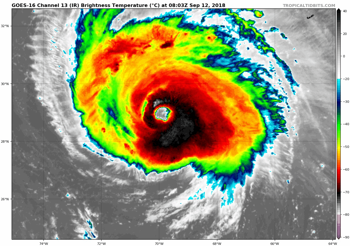
Hurricane Florence is still strong this morning with 130 mph winds and is looking like it will get stronger today. My prior report mentioned the European Model stalling this offshore and then shifting the track southward inland to South Carolina and Georgia. There is more support for that and the slow movement will be absolutely devastating! While that is better news for Maryland (and we will end up with a nicer weekend), this is a larger storm. So the wind reach is still just on the edge of our region.
We still have rain today to deal with, so this post will start with our local weather first. All of the Hurricane Florence Info is below.
Local Weather Stats For September 12 in Baltimore
Average High: 79ºF
Record High: 96ºF in 1931
Average Low: 59ºF
Record Low: 43ºF in 1967
Sunrise: 6:44 AM
Sunset 7:19 PM
*Daylight = 2:31 shorter than yesterday
*Bay Water Temperature = 76ºF at Thomas Pt. Light House
Also see:
Winter Outlook From Two Different Farmers Almanacs
Video of Hurricane Hunter flying into the Eye and first call for track shifting
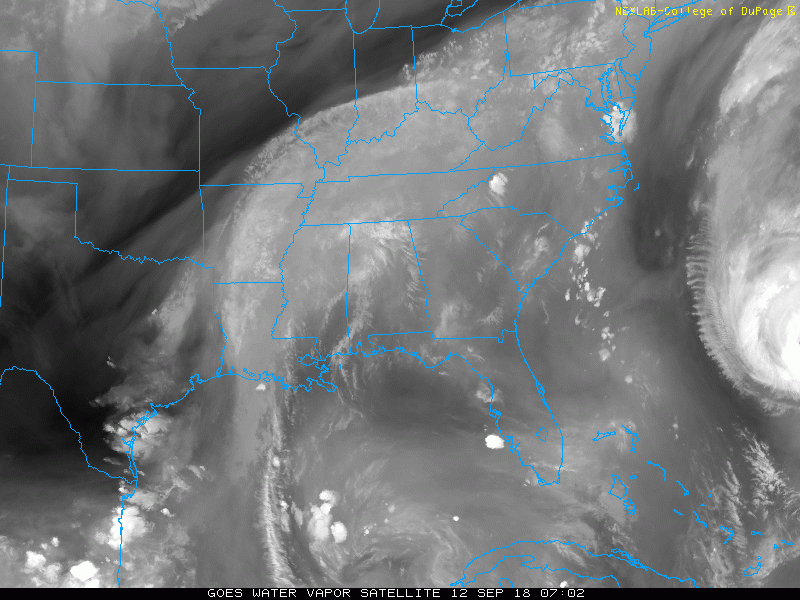
Regional Satellite
The clouds in place are form the old frontal boundary. Hurricane Florence is seen on the high just on the edge of this view. It is NOT influencing our weather yet, but we will have some tropical like feel to the air along with showers and storms developing.
Radar Simulation —> slider
[metaslider id=65481]
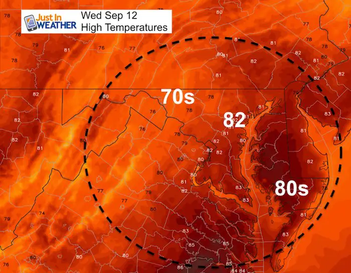
High Temperatures
Hurricane Florence
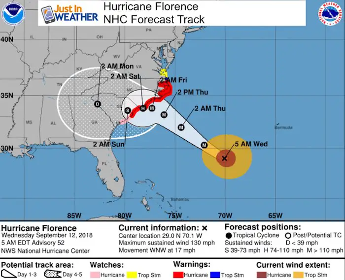
SUMMARY OF 500 AM EDT…0900 UTC…INFORMATION
LOCATION…29.0N 70.1W
ABOUT 575 MI…925 KM SE OF CAPE FEAR NORTH CAROLINA
MAXIMUM SUSTAINED WINDS…130 MPH…215 KM/H
…28 KM/H MINIMUM CENTRAL PRESSURE…946 MB…27.94 INCHES
Satellite Loop
Wind Field
- Hurricane Force Winds (over 74 mph) reach 40 miles from the center.
- Tropical Storm Force Winds (over 39 mph) reach 150 miles away.
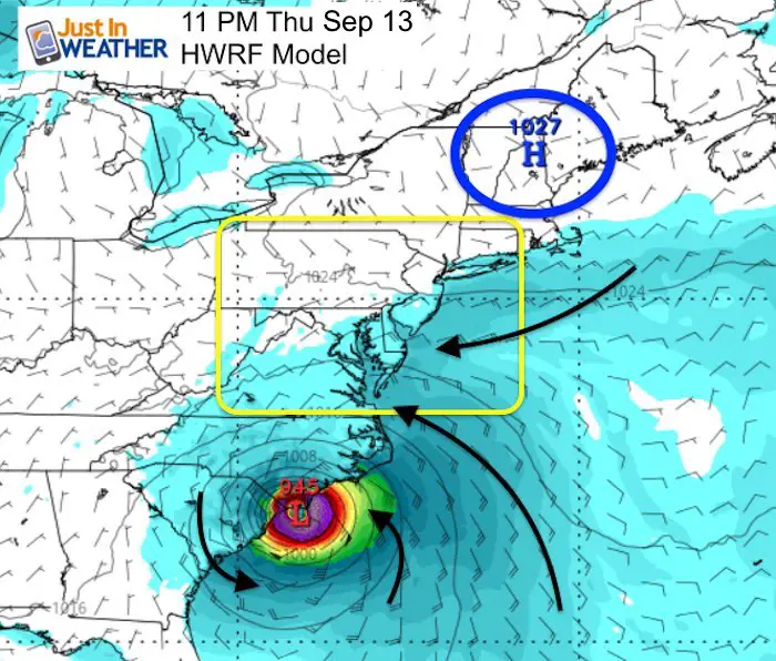
Landfall Expectation
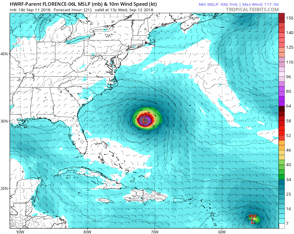
Similar to what I showed yesterday, the HWRF also shows Florence nearly stalling off of the coast around Wilmington. Should this happen, it would extend the devastation for that area, but limit the impacts farther north in Virginia and Maryland.
The same High Pressure blocking the storm will keep the winds from the EAST. That will pile up water on the coast AND the western shore of the Chesapeake Bay… But not a pure storm surge. Each high tide wil have trouble draining out, keeping water levels high.
Storm Surge Warning
The direct impact of the storm surge water is shown here. Some places near Wilmington can see water levels 9 to 13 feet high.
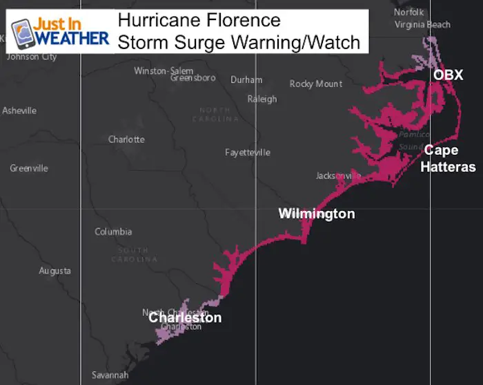
Cape Fear to Cape Lookout, including the Neuse, Pamlico, Pungo, and
Bay Rivers...9-13 ft
North Myrtle Beach to Cape Fear...6-9 ft
Cape Lookout to Ocracoke Inlet...6-9 ft
South Santee River to North Myrtle Beach...4-6 ft
Ocracoke Inlet to North Carolina/Virginia Border...4-6 ft
Edisto Beach to South Santee River...2-4 ft
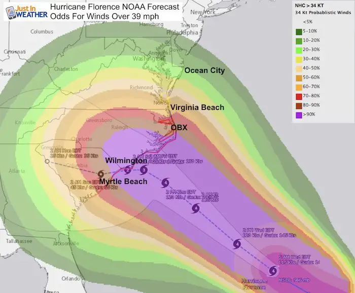
Wind Reach
Southern Maryland will be on the edge with some chance to get gusts over 39 mph, but not expected into central Maryland. The stronger winds over 59 mph are not likely locally.
Tropical Storm Force Wind Expectation
Winds Over 58 mph Expectation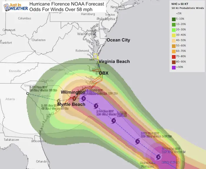
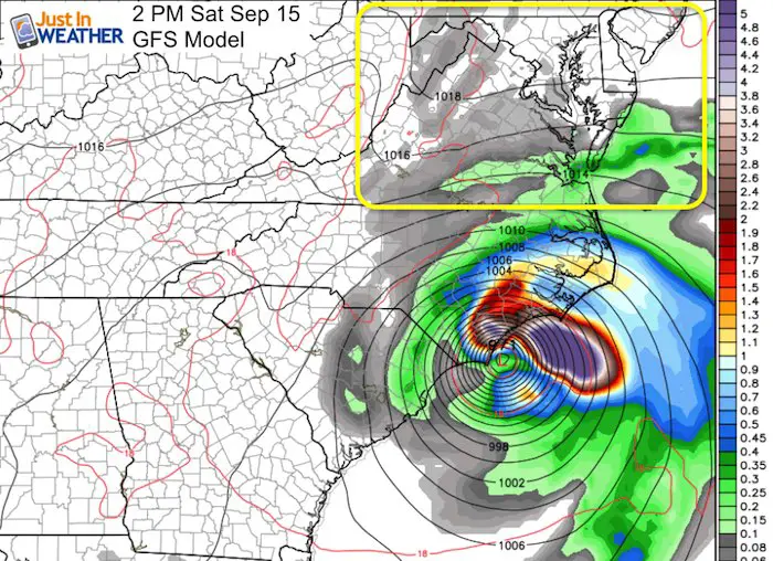
Forecast Track South
This is the GFS Model showing the storm Saturday afternoon STILL NEAR Wilmington. This was the first model to show the stall off of the coast, just in a different location. It is now in sync with the position and track. Notice the lack of moisture in Maryland. Some showers and more clouds near Ocean City, but the rest of the state may have a few nice days.
Hurricane Florence Forecast Animation
This is the stall, crawl, and shift into South Carolina and Georgia. This brings the Low into Tennessee Sunday.
National Hurricane Center Forecast Track
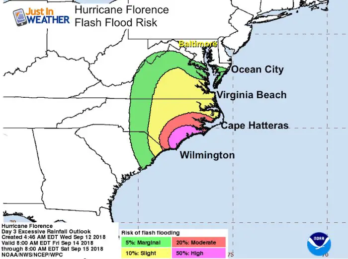
Flash Flood Risk Forecast
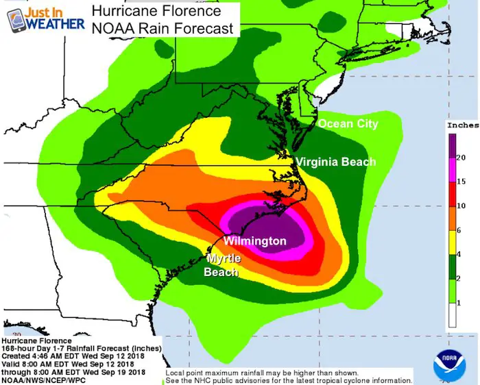
Rainfall Forecast
Over 20 inches expected in a wide region near the core along coastal North Carolina. This may start to be compared to Hurricane Harvey that stalled over Houston last year.
Keep In Touch Every Day
Click here to sign up for email alerts…. Just in case you don’t get the post on your social media feed
Please share your thoughts, best weather pics/video, or just keep in touch via social media
-
Facebook: Justin Berk, Meteorologist
-
Twitter: @JustinWeather
-
Instagram: justinweather
Love Maryland Shirt Designed By Jaiden
 |
|
This shirt was designed by my ‘bonus’ daughter Jaiden. All proceeds will go to Just In Power Kids and free holistic therapy for kids in and post cancer treatment.
Show your love for Maryland and make this 14 year old artist extra proud
|
Now Scheduling School Assemblies
- Storm Smart – Severe Weather (September, October; March through May)
- FITF – Snow and ice (November through March)
Programs for K through Middle School
Choose flat fee or FREE along with a spirit wear shirt fundraiser that earns your school money.
Power Partner Just In Power Kids and Maryland Trek 5:

Still Time To Support Just In Power Kids
We are still taking donations for our best Maryland Trek yet. Every penny goes to Just In Power Kids programs to provide FREE holistic care for kids in cancer treatment and up to 5 years post treatment.
![]()
 Get the award winning Kid Weather App I made with my oldest son and support our love for science, weather, and technology. Our 3 year anniversary of the release and our contribution to STEM education is this November. It has been downloaded in 60 countries, and works in both temperature scales. With your support we can expand on the fun introduction to science and real weather.