 Sunday September 9 2018
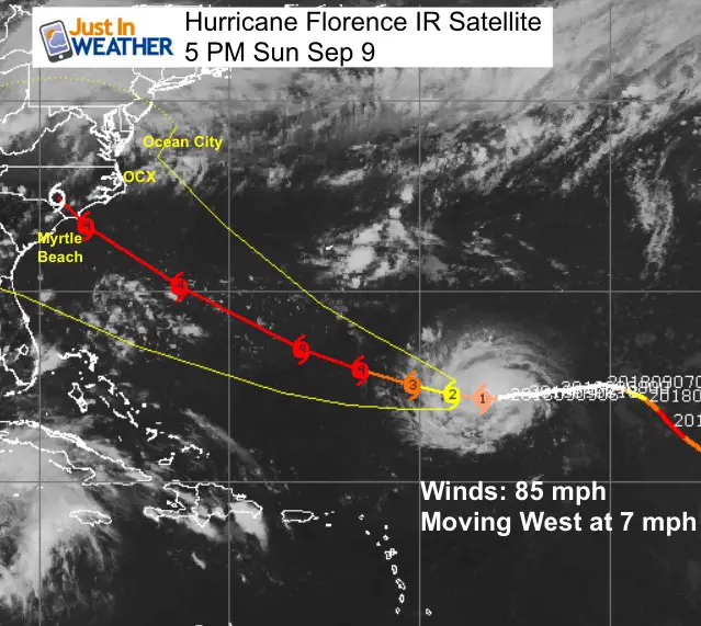
Hurricane Florence is getting stronger. The latest update has winds of 85 mph, but it is a small storm with hurricane force winds only 25 miles from the center. Tropical storm force winds extend 125 miles away from the center. It is organized and showing sings of strengthening as seen in the satellite loop below.
The latest model package suggest this will make landfall on the east coast of the US, but there is still a chance it could slow down and stall just off of the coast. Either way, it will be a big impact for shipping and beaches. It will also spread rain farther from the storm as it approaches the coast. Here’s a look at the set up and what to watch as it continues to grow stronger and closer.
Longwave IR Satellite Loop
Watch the intensity of color clouds wrap around counter-cloudwise around the center, while the higher cirrus clouds wrap clockwise. This signals a healthy tropical storm structure.

5 PM Sunday Update
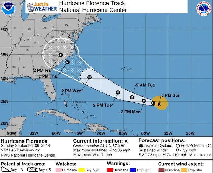
SUMMARY OF 500 PM AST...2100 UTC...INFORMATION
----------------------------------------------
LOCATION...24.4N 57.0W
ABOUT 720 MI...1160 KM SE OF BERMUDA
ABOUT 580 MI...935 KM NE OF THE NORTHERN LEEWARD ISLANDS
MAXIMUM SUSTAINED WINDS...85 MPH...140 KM/H
PRESENT MOVEMENT...W OR 270 DEGREES AT 7 MPH...11 KM/H
MINIMUM CENTRAL PRESSURE...975 MB...28.80 INCHES
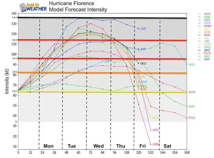
Florence Intensity Forecast
Category
- = 74 to 95 mph wind
- = 96 to 110 mph
- = 111 to 130 mph
- = 131 to 155 mph
- = 156+ mph
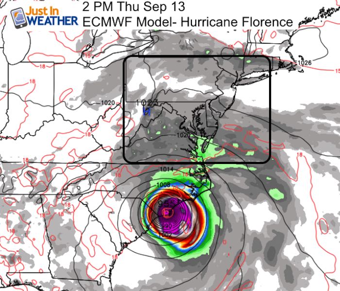
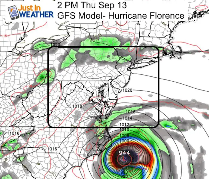
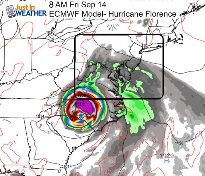
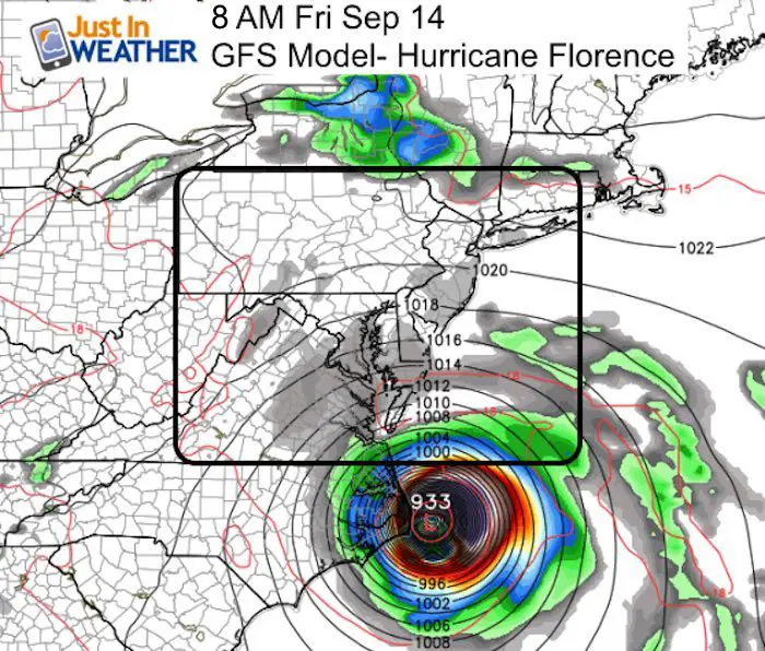
Comparing Two Models With 24 Hour Difference In Landfall Time
The ECMWF (European Model) is about a day faster allowing Florence to make landfall near Wilmington, NC on Thursday. The GFS Model is slower which allows other factors to steer it and stall it around Cape Hatteras and OBX. The heavy weight of modeling supports the European Model, but the GFS is consistent, so it’s worth watching the forward speed to help with hints of which may have a better handle on this.
Thursday Afternoon European Vs GFS
 |
 |
Friday Morning European Vs GFS
 |
 |
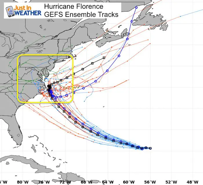
GEFS Model Ensemble Tracks…
Forecast Animations
Here is the ‘Stall’ off the coast

Here is the track inland solution

National Hurricane Center
This track is in line with the ECMWF and HWREF Models shown above… along with most of the ensemble
Will it impact Maryland?
Timing is one issue to affect where it may approach the coast. But then the storm could stall. It is too early to determine if that will be close enough to throw rain our way or not. But the time frame across the Mid Atlantic will be Thursday through possibly the following Tuesday. It could be hanging around for a while.
I expect a lot of adjustment as we get closer. Should we get an impact it will be:
- Rip Currents- all week.
- Possible Flooding/ Surge Up The Bay (The path would need to be north of OBX to be like Isabel. South of there and the shape of the coast protects us a lot) – Within a day of landfall
- Flooding Rain
- Time Frame – Thursday Through Saturday- all depending on the speed and if it stalls
Love Maryland Shirt
 |
This shirt was designed by my ‘bonus’ daughter Jaiden. All proceeds will go to Just In Power Kids and free holistic therapy for kids in and post cancer treatment.
Show your love for Maryland and make this 14 year old artist extra proud
|
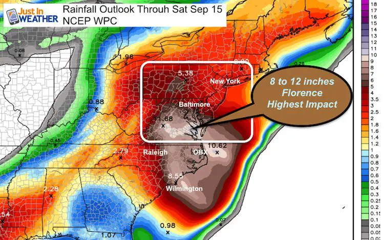
Rainfall Potential Through Next Saturday
This rainfall outlook does include some of the rain from today. I have highlighted the core of Florence potential rain… Depending on if and where it could stall… That could blow the rain totals up big time! So this is just a guide, but not a promise.
Keep In Touch Every Day
Click here to sign up for email alerts…. Just in case you don’t get the post on your social media feed
Please share your thoughts, best weather pics/video, or just keep in touch via social media
-
Facebook: Justin Berk, Meteorologist
-
Twitter: @JustinWeather
-
Instagram: justinweather
Power Partner Just In Power Kids and Maryland Trek 5:

Still Time To Support Just In Power Kids
We are still taking donations for our best Maryland Trek yet. Every penny goes to Just In Power Kids programs to provide FREE holistic care for kids in cancer treatment and up to 5 years post treatment.
![]()
 Get the award winning Kid Weather App I made with my oldest son and support our love for science, weather, and technology. Our 3 year anniversary of the release and our contribution to STEM education is this November. It has been downloaded in 60 countries, and works in both temperature scales. With your support we can expand on the fun introduction to science and real weather.