 Saturday September 8 2018
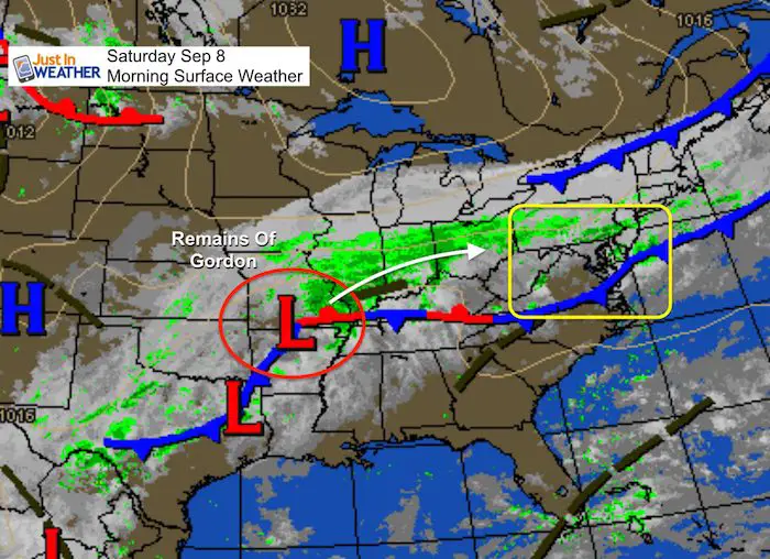
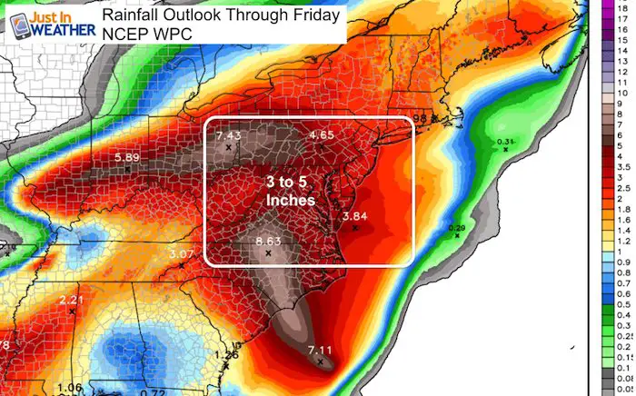
There is so much to talk about with rain and flooding today and this weekend are thanks to a stalling front and the remains of Gordon. A big chill will affect The Ravens home opener that might surprise you Sunday afternoon. Plus, Florence is expected to become a major hurricane again and get very close to the North Carolina Outer Banks by next week. My goal is to share all of this but that includes a lot of maps. I’ll make the reading quick to help you plan ahead. Below you will find animations for this morning’s radar, rain through the weekend, and the GFS Hurricane Florence track stalling and looping off of the east cast again.
Local Weather Stats For September 8 in Baltimore
Average High: 81ºF
Record High: 100ºF in 1939
Average Low: 61ºF
Record Low: 46ºF in 1962
Sunrise: 6:41 AM
Sunset 7:26 PM
*Daylight = 2:29 shorter than yesterday
*Bay Water Temperature = 83ºF at Thomas Pt. Light House * This is the warmest the water has been all year!
Also see: Winter Outlook From Two Different Farmers Almanacs
Morning Snapshot
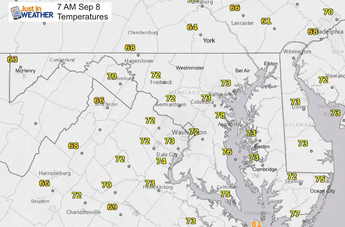
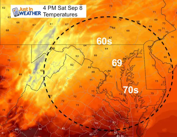
Temperatures
Note: It will get cooler this afternoon… The 60s will drop from PA into metro Baltimore. It will be even cooler tomorrow. Southern Maryland will stay in the 70s through Sunday.
Radar Loop
Plenty of rain this morning from Gordon on the Ohio Valley… The front is slow moving and will keep rain falling over the same areas.

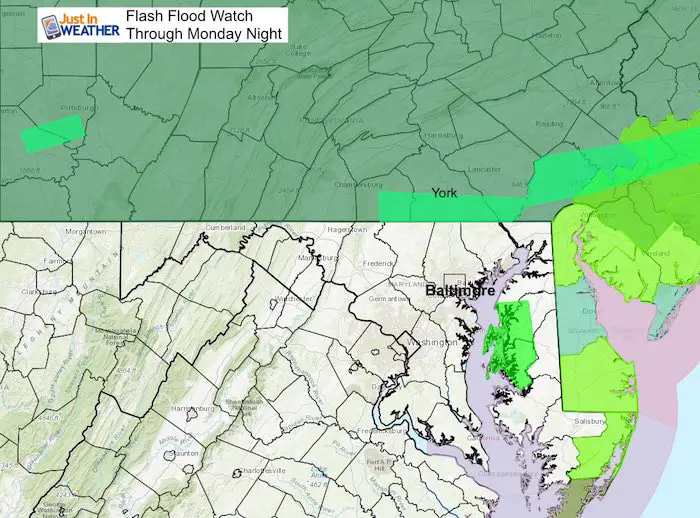
Flooding Rain
The Flood Watch is currently focused on Pennsylvania and north. This goes to 8 PM Monday! This is where the heaviest rain is expected to fall, but I think parts of north central Maryland are subject to be included as the rain redevelops over already soggy flooded areas.
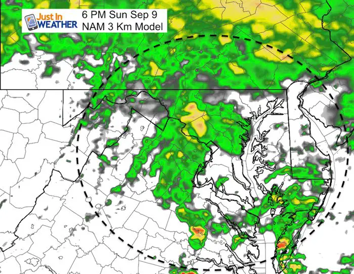
Weekend Rain
This is the NAM Model Forecast Through Sunday Night
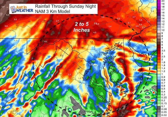
Rainfall Today —> slider
[metaslider id=65265]
Afternoon Temperatures
It will be cooler than this morning
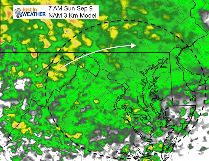
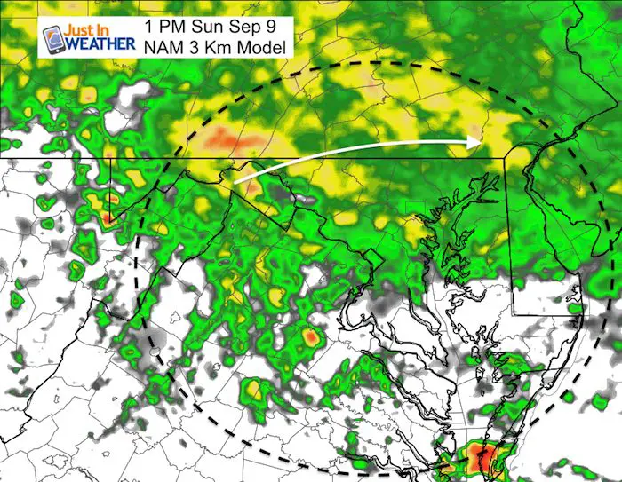
Rain Snapshots Sunday
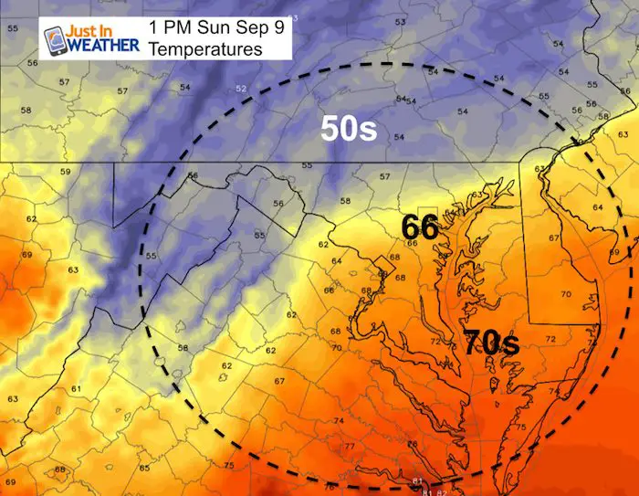
Ravens Game
Temperatures
Kick off in Baltimore will be in the mid 60s. Northern areas in the 50s and southern Maryland remains in the 70s
Rain Animation
Notice the heavy rain just north in PA, but the front stalling over the area through early next week.

Week Ahead
This includes the weekend rain and whatever may arrive from Florence next week.
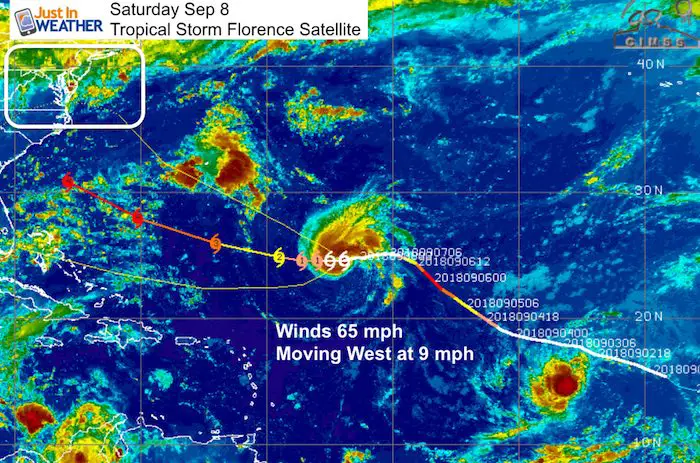
Florence
This is a tropical storm this morning with 65 mph winds. But it is expected to become a major hurricane as it gets closer to the US.
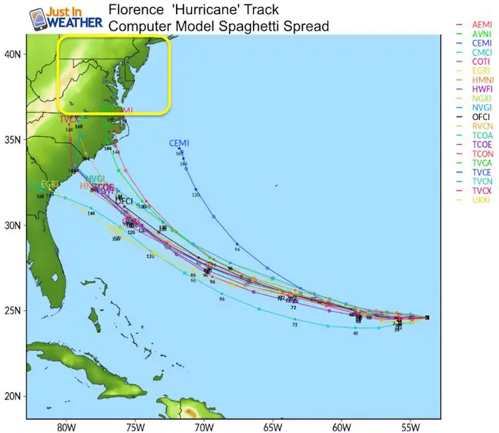
Yesterday I wrote about the computer modeling that has not locked in on this storm yet. There are many factors over the next week that can direct the path. This snapshot shows a close blow to North Carolina, but the GFS Model is once again back to no landfall but looping off of the coast. High Pressure in eastern Canada will play a role in suppressing the storm’s attempt to curve north.
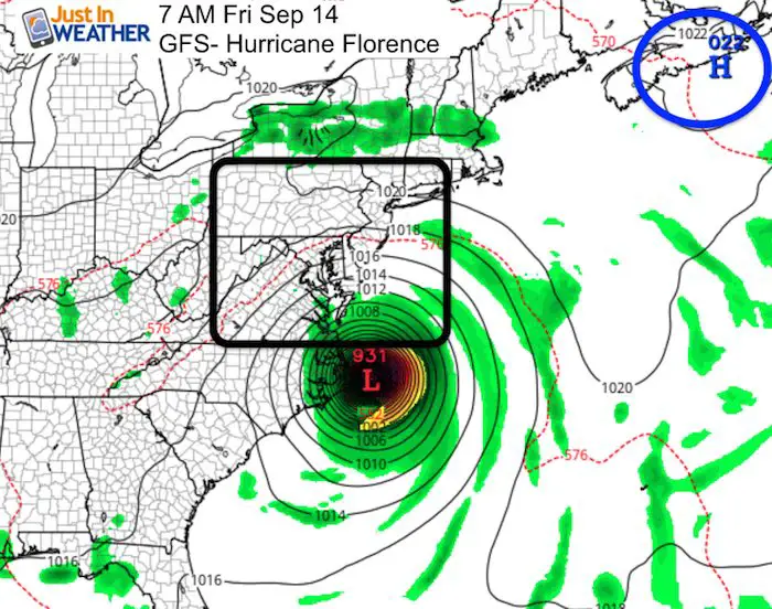
This morning’s path has shifted a little father south. That may also allow this storm to slow down and miss some steering currents.
Florence Forecast Model Spread
The consensus is that Florence will be between a Category 2 and 4 intensity next week.
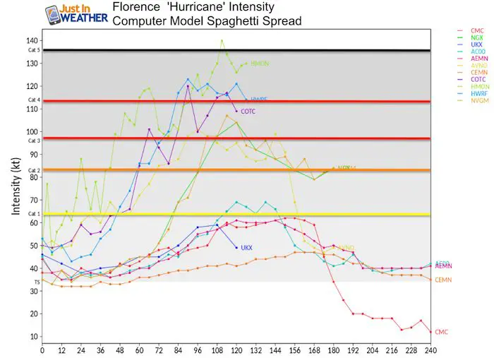
The majority of plots do show landfall, but not all models agree on that…
GFS Model Animation
This GFS Model is back to stalling and looping off of the east coast with a close blow but no landfall.
I continue to caution the precise landfall at this time. But the entire east coast will be subjected to high waves and rip currents. That will affect late beach trips and cruise vacations to Bermuda.

Now Scheduling School Assemblies
- Storm Smart – Severe Weather (September, October; March through May)
- FITF – Snow and ice (November through March)
Programs for K through Middle School
Choose flat fee or FREE along with a spirit wear shirt fundraiser that earns your school money.
Please share your thoughts, best weather pics/video, or just keep in touch via social media
-
Facebook: Justin Berk, Meteorologist
-
Twitter: @JustinWeather
-
Instagram: justinweather
Keep In Touch Every Day
Click here to sign up for email alerts…. Just in case you don’t get the post on your social media feed
Power Partner Just In Power Kids and Maryland Trek 5:

Still Time To Support Just In Power Kids
We are still taking donations for our best Maryland Trek yet. Every penny goes to Just In Power Kids programs to provide FREE holistic care for kids in cancer treatment and up to 5 years post treatment.
![]()
 Get the award winning Kid Weather App I made with my oldest son and support our love for science, weather, and technology. Our 3 year anniversary of the release and our contribution to STEM education is this November. It has been downloaded in 60 countries, and works in both temperature scales. With your support we can expand on the fun introduction to science and real weather.