 Monday May 14 2018
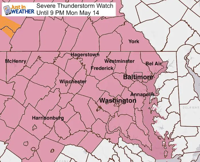
We really stepped right into prime severe weather season. After a very busy weekend, we need to pay attention for the potential for more large hail. A Severe Thunderstorm Watch is in place until 9 PM this evening. This includes much of Maryland and Pennsylvania counties west of the Chesapeake Bay and Susquehanna River. Much like recent events, we are not on the warm side of this old stationary boundary, but the storms will be riding on the north side. There is enough heat and energy, plus cold air aloft that can help produce large hail. We have had a few recent days with hail stones larger than quarters and even golf balls.
A Derecho is when the intense line of storms has wind speed exceeding 60 mph for 6 hours or longer. The forward speed reaches 40 mph. That means it holds severe limit strength for a path over 240 miles. While NWS has discussed this potential, it is not at that status at this time.
Severe Alert Notes:
Watch means it MIGHT happen. The prime threat includes large hail, winds over 60 mph, and isolated tornadoes.
Warning means it IS HAPPENING AND BEING TRACKED.
See the radar simulation and weather timeline below.
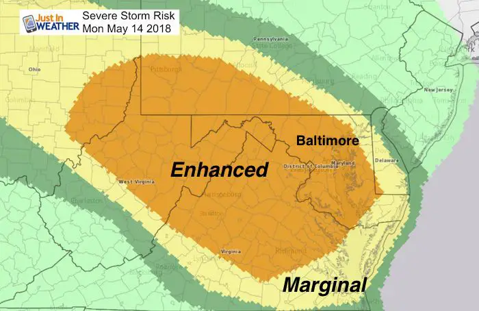
Increased Risk
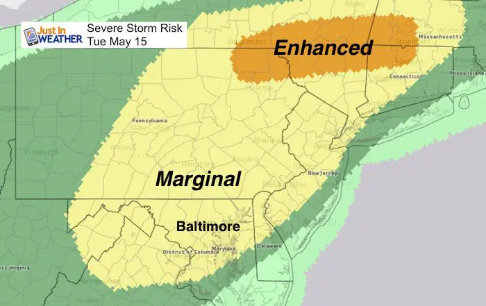
This Enhanced Risk from The Storm Prediction Center means there will be widespread storms with favorable conditions to reach severe limits. Storms will be forming in the mountains and ride to the east and southeast in our direction this afternoon and evening . We remain in the Slight Risk Tuesday.
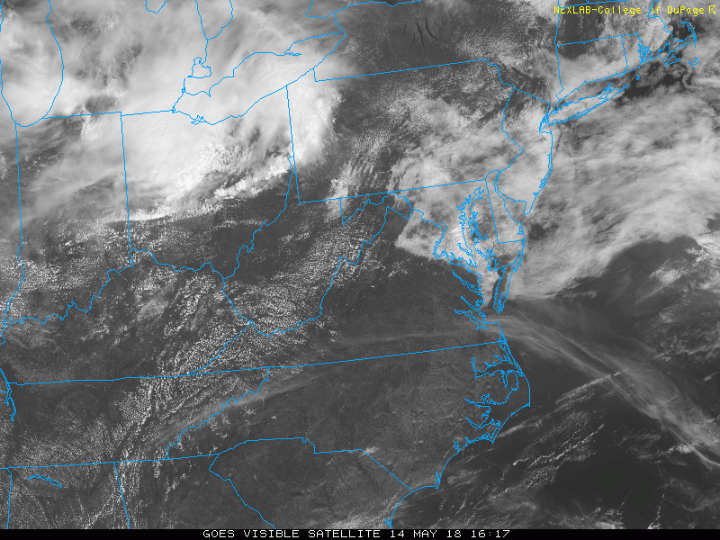
Visible Satellite Loop
This 2 hour weather loop between noon and 2:12 PM shows the fog and low clouds burning off neat the Bay and storms brewing in Ohio and western Pennsylvania. This is the region to our west we need to watch. As we saw Friday, some storms can develop ahead of this cluster.
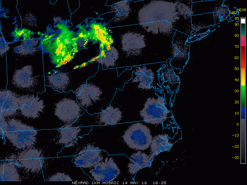
Radar Loop: 2 Hours Ending 2:20 PM
Rain and severe storms tracking from Ohio to Pennsylvania is the weather heading in our direction this evening.
Radar Simulation —> slider
HRRR Model
The worst storms and biggest impact will be between 5 PM and 8 PM
[metaslider id=62086]
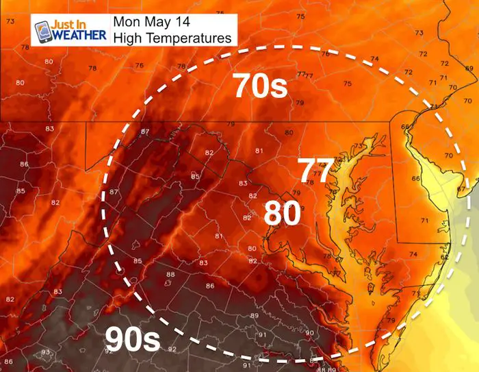
High Temperatures
The hot weather is to our south, but the energy will be rising in the region north of the front.
Tuesday- Slight Risk For Severe Storms
The main focus of strong storms will shift to the north, but we may still have clusters of severe weather develop during the afternoon.
Please share your thoughts, best weather pics/video, or just keep in touch via social media
-
Facebook: Justin Berk, Meteorologist
-
Twitter: @JustinWeather
-
Instagram: justinweather
Keep In Touch Every Day
Click here to sign up for email alerts…. Just in case you don’t get the post on your social media feed
![]()
Shine On
Proceeds from all sales go to Just In Power Kids. Click the image to shop and show your support.

 Get the award winning Kid Weather App I made with my oldest son and support our love for science, weather, and technology. Our 3 year anniversary of the release and our contribution to STEM education is this November. It has been downloaded in 60 countries, and works in both temperature scales. With your support we can expand on the fun introduction to science and real weather.