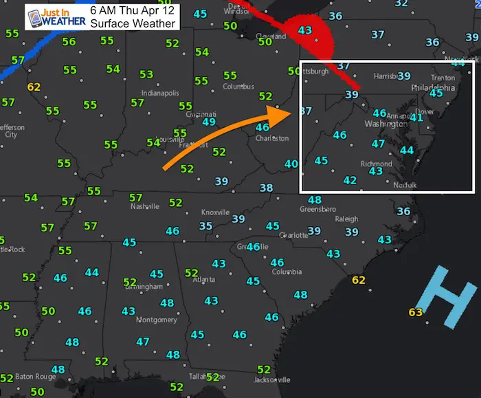
Thursday April 12
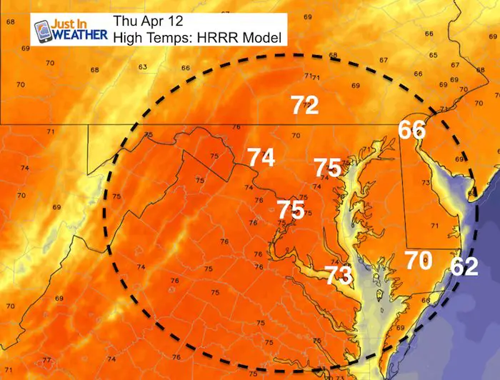
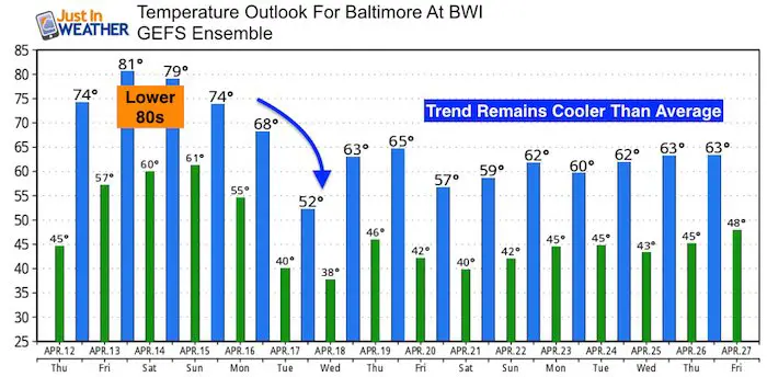
A warm front will be passing through this morning with a chance for brief rain. This will then open up the door to warmer air as we reach the mid 70s this afternoon. Go figure that we get a warm day in spring. We actually did hit the 70s on April 4th and 7th. We are expected to surge into the 80s for two days as the models are now supporting my push for that mark. As we talk about temps it is important to remind you that places any the Bay and near the Ocean will remain cooler. Also, enjoy it while it is here this weekend. Showers will try to build in Sunday, with the strongest storms Sunday night into Monday morning. Then we settle back into a cooler pattern next week.
Stats For April 12
Average High: 64ºF
Record High: 88ºF in 1977
Average Low: 42ºF
Record Low: 27ºF in 1874
Snow Record: 0.4″ in 1956
Seasonal Snow To Date (at BWI): 15.2
Sunrise: 6:33 AM
Sunset 7:41 PM
*Daylight = 2:28 longer than yesterday
*Bay Water Temperature = 47ºF at Thomas Pt. Light House
Keep In Touch Every Day
Click here to sign up for email alerts…. Just in case you don’t get the post on your social media feed
Ready To Shine On This Spring?
Proceeds from all sales go to Just In Power Kids. Click the image to shop and show your support.

This Morning
We start off chilly in the 30s and 40s, but a new air mass is on the other side of that warm front.
Rain Timeline With Warm Front —> slider
[metaslider id=61138]
This Afternoon
Wild Weekend
First check out the temperature trend hitting the 80s Friday and Saturday then crashing early next week. Note, Monday morning’s highs will be in the morning
Storm Animation
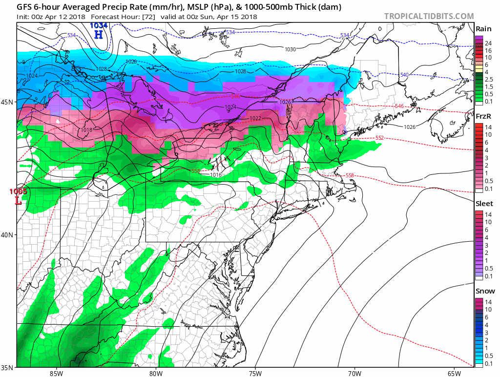
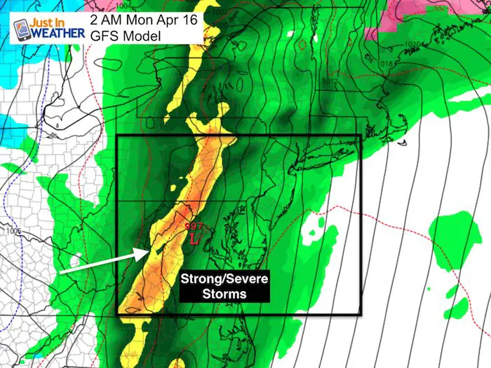
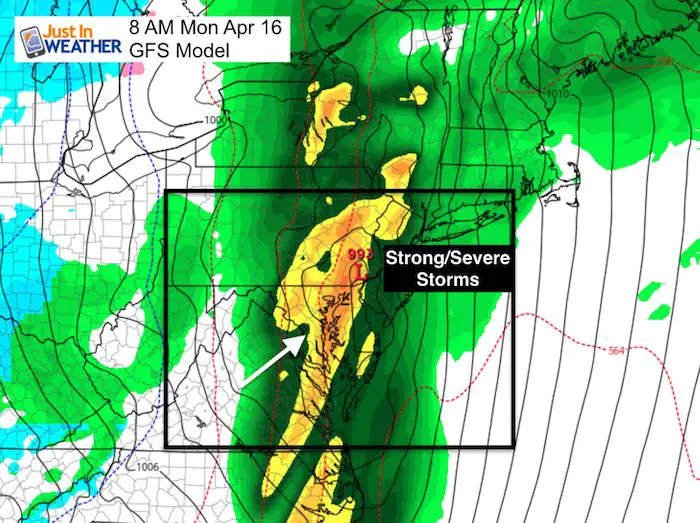
Storm Timing
The main line of storms will reach us Sunday night into Monday morning
Outlook: Warm Spell Ends Sunday With Storms
Often we end up warmer than models first show, so I think we have a good chance for the 80s both Friday and Saturday.
The outlook next week may end up colder than shown here as the model trends towards average. But all model indications are reinforcing cold surges.
Shine On
Proceeds from all sales go to Just In Power Kids. Click the image to shop and show your support.
![]()
 Get the award winning Kid Weather App I made with my oldest son and support our love for science, weather, and technology. Our 3 year anniversary of the release and our contribution to STEM education is this November. It has been downloaded in 60 countries, and works in both temperature scales. With your support we can expand on the fun introduction to science and real weather.
Also See:
My Winter Outlook 2017-2018 for more snow
La Nina Formed: What it could mean to our winter
NOAA Winter Outlook: Not The Best But Not The Worst For Snow
Two Farmers Almanacs Winter 2018 Outlooks
Winter Weather Folkore: Suggestions from Animals and Crops
First Frost and Freeze Dates For Maryland (southern PA and northern VA)
My Preliminary Winter Outlook Notes
Low Snow Winters In Baltimore: To Repeat Or Not Repeat
NOAA Ranks Blizzard 2016 4th Worst Snowstorm On Record
Blizzard 2016 Record Top Snowstorm: Area Totals
Extreme Weather of 2015 balanced out on both ends