 March 30 2018
Today is both Good Friday and the start of Passover. If there is crossover and you have lingering Faith in the Flakes, you might get some April snow validation on Monday. This is not a delayed April fools joke and my FITF line is closed for the season. Even I have moved on with Shine On and the sights on spring. Heck, baseball season just began AND we were in the 70s this morning. But Mother Nature has another idea.
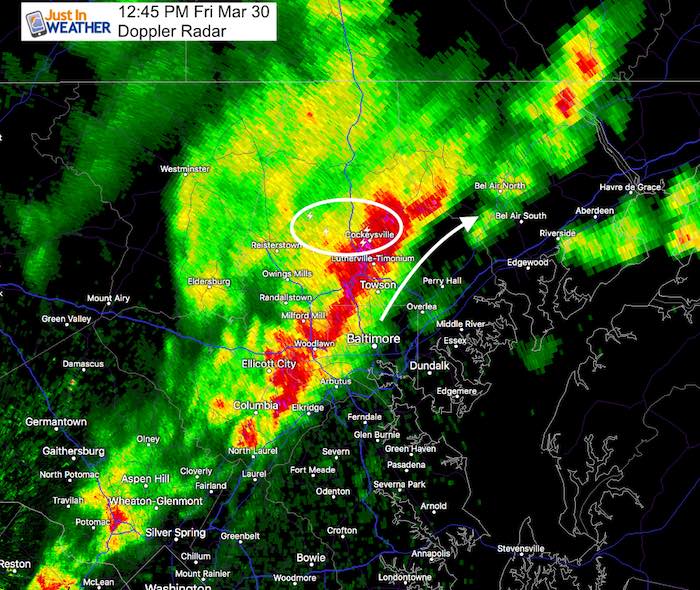
One strong band of rain is moving through early this afternoon as the cold front will be bringing colder air back in for the holiday weekend. Below is a look at today’s radar simulation. Then we can look ahead briefly to the system that is trying to bring in some snow Monday morning.
Stats For March 30
Average High: 59ºF
Record High: 89ºF in 1998
Average Low: 38ºF
Record Low: 21ºF in 1887
Snow Record: 2.6″ in 2003
Seasonal Snow To Date (at BWI): 15.2″
Sunrise: 6:53 AM
Sunset 7:28 PM
*Daylight = 2:34 longer than yesterday
*Bay Water Temperature = 45ºF at Thomas Pt. Light House
Keep In Touch Every Day
Click here to sign up for email alerts…. Just in case you don’t get the post on your social media feed
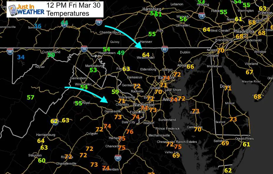
Temperatures at Noon
Rain Timeline —> slider
[metaslider id=60813]
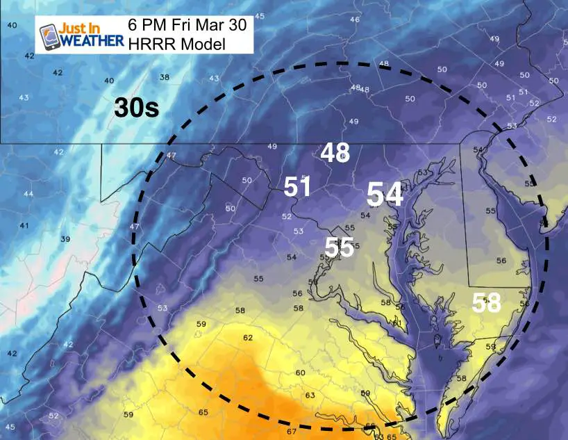
Temperatues At 6 PM
Weekend Notes:
We will be dry but cooler with highs in the 50s Saturday and near 50ºF Sunday.
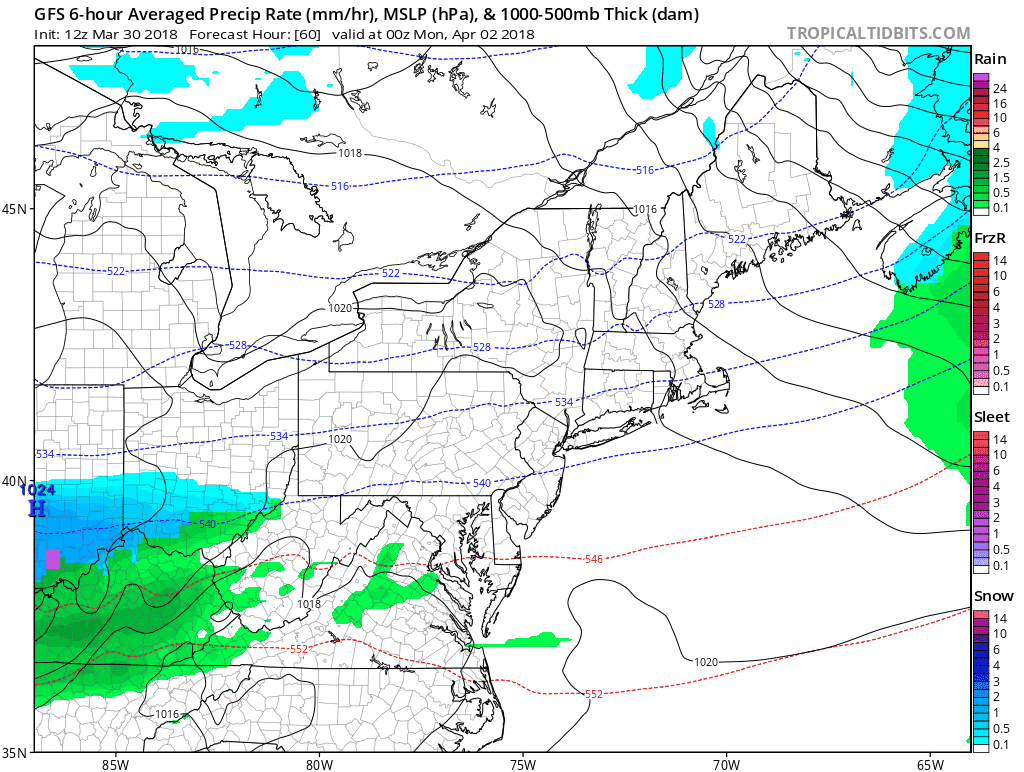
Snow Potential – THIS IS NOT A JOKE
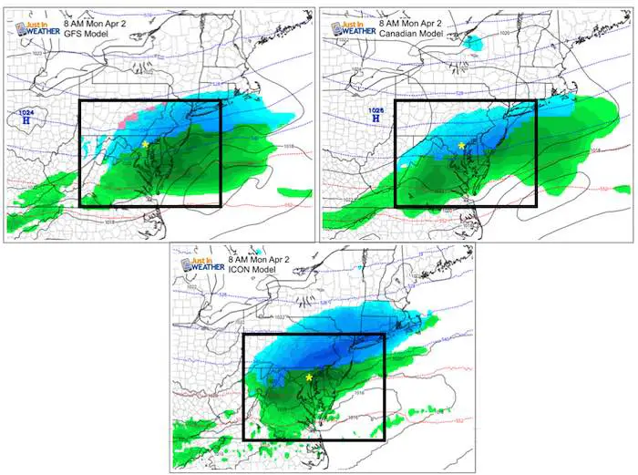
I didn’t want to mention this two days ago thinking the modeling was glitching and it would correct itself. Well, this system crossing the nation this weekend will have just enough cold air on the north end to produce snow. At least we get a dry Easter out of this, but Monday morning may start with some snow. The tying is best for any potential stickage, but I am going to play this conservative at this point and lean on the side of wet roads. This is something to pay attention to just in case there is any adjustment worth mentioning.
Here is a comparison of the GFS and Canadian Models both showing snow near and north of Baltimore Monday morning. I’ve added a new model I want to introduce you to. This is the ICON, initiates by the Max Planck Institute for Meteorology in Hamburg Germany. Some call it the German Model. Here it adds some contrast showing a warmer solution.
Storm Animation
GFS Model
![]()
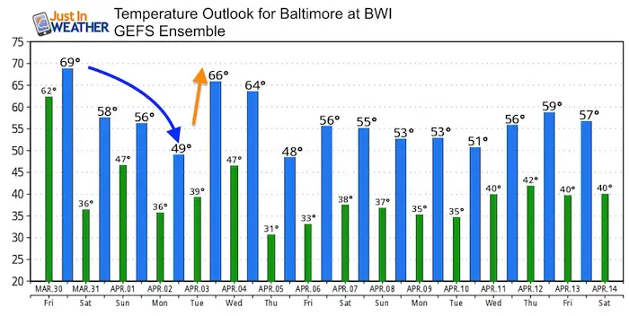
Temperature Outlook
Shine On
Proceeds from all sales go to Just In Power Kids. Click the image to shop and show your support.

![]()
 Get the award winning Kid Weather App I made with my oldest son and support our love for science, weather, and technology. Our 3 year anniversary of the release and our contribution to STEM education is this November. It has been downloaded in 60 countries, and works in both temperature scales. With your support we can expand on the fun introduction to science and real weather.
Also See:
My Winter Outlook 2017-2018 for more snow
La Nina Formed: What it could mean to our winter
NOAA Winter Outlook: Not The Best But Not The Worst For Snow
Two Farmers Almanacs Winter 2018 Outlooks
Winter Weather Folkore: Suggestions from Animals and Crops
First Frost and Freeze Dates For Maryland (southern PA and northern VA)
My Preliminary Winter Outlook Notes
Low Snow Winters In Baltimore: To Repeat Or Not Repeat
NOAA Ranks Blizzard 2016 4th Worst Snowstorm On Record
Blizzard 2016 Record Top Snowstorm: Area Totals
Extreme Weather of 2015 balanced out on both ends