 Wednesday March 7 2018
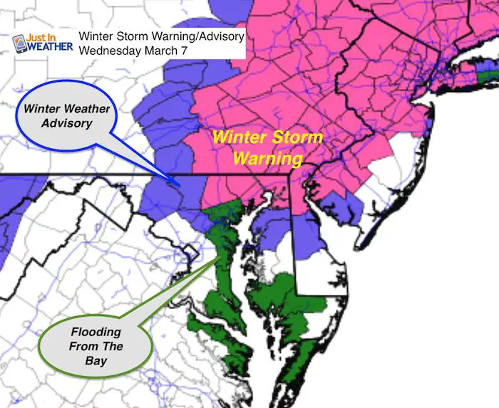
A Winter Storm Warning was expanded to include all of Harford County. A Winter Weather Advisory continues in central Maryland where this snow is over achieving. However flooding already an issue on the Chesapeake Bay (green). Water may run 2 to 3 feet above average thanks to the winds around the storm.
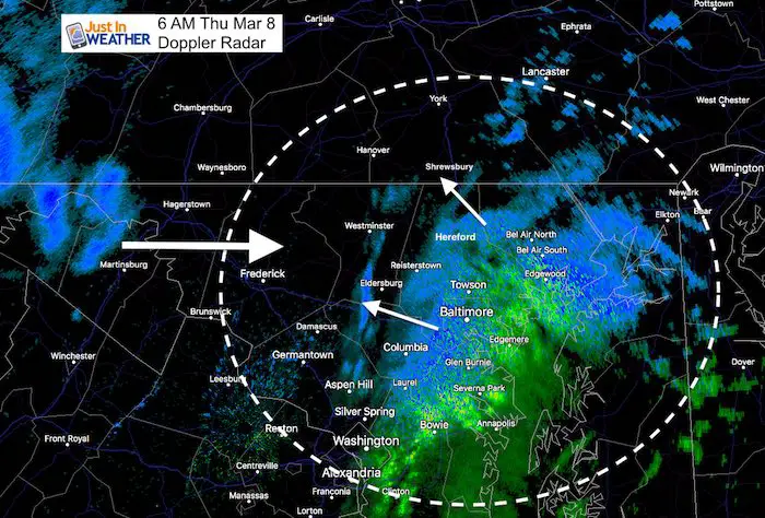
Today is starting with an over achiever around Baltimore city and northeastern Maryland, while it has been a bust in others. While many schools have delayed or closed in central Maryland, southern Pennsylvania has missed out on the first part of this event with almost nothing on the ground there yet. The second part is developing this morning as expected, but will be less intense and have to battle the sun angle.
Most roads are wet and will stay wet. There will be some slush, especially on elevated roads/bridges. But the main accumulation will be on the grass. However, moderate snow can reduce visibility making driving difficult.
6 AM Roundup
See my adjusted snow map and snow simulation slider below.
Doppler Radar
The storm is phasing/developing now. See this will fill in to the north into York and back west to Carroll and Frederick Counties over the next 1 to 2 hours
Snow Timeline —> slider
Phasing is occurring now. This is the time we watch the storm expand in coverage and intensity but may be a little late and lose to the sun.
Note that due to mild temperatures, snow will be heavy and wet. But when it eases up and is lighter, it may mix or turn to rain
[metaslider id=59963]
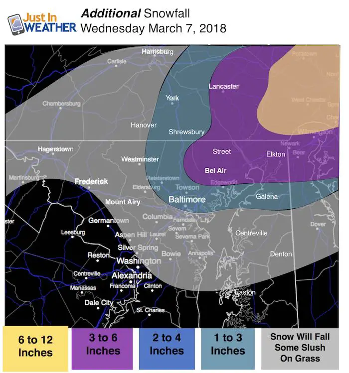
Additional Snow Possible Today
Here is my adjusted snow map for what may fall today. See the new radar simulation slider below
Note that snow during the day will likely stick on the grass but roads will be wet
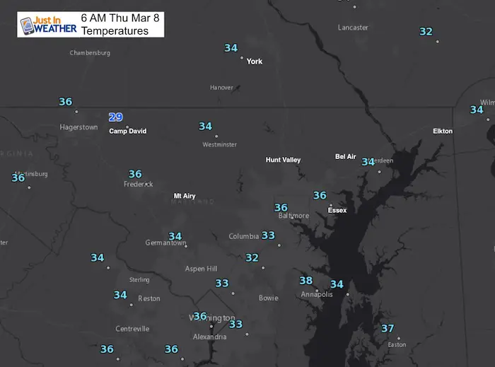
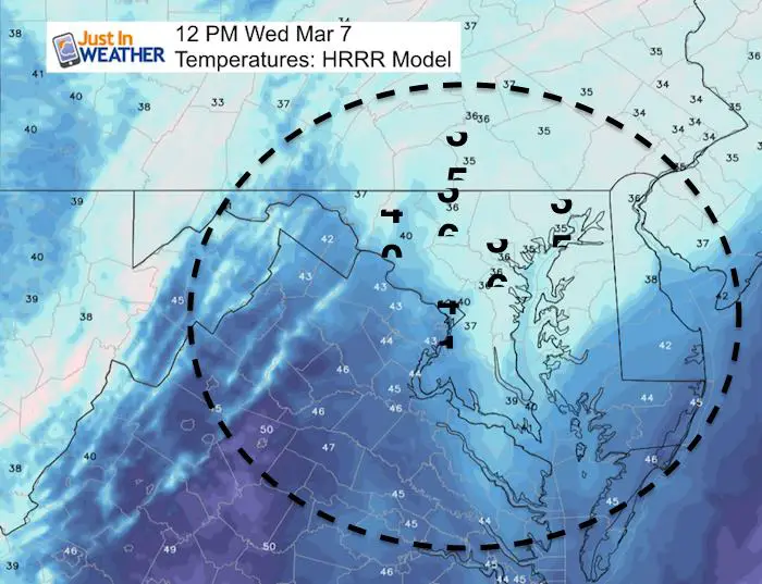
Temperatures
Noon Today: Snow will be falling while temps are above freezing AND battle the March sun angle. That means more snow will melt and compact
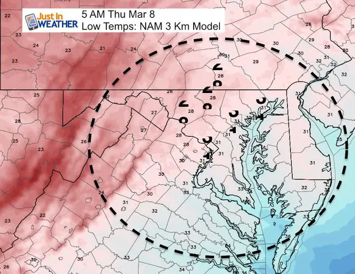
ReFreezing Thursday Morning
Please share your thoughts, best weather pics/video, or just keep in touch via social media
-
Facebook: Justin Berk, Meteorologist
-
Twitter: @JustinWeather
-
Instagram: justinweather
Keep In Touch Every Day
Click here to sign up for email alerts…. Just in case you don’t get the post on your social media feed
FITF Sale
To celebrate the late season snow storm, all FITF webstore apparel is now 20%. Use promo code: marchsnow now! Shop FITF

Snowstix- We Need You To Measure Snow Too
We are giving 10% of each sale to programs that benefit pediatric oncology patients.

 Get the award winning Kid Weather App I made with my oldest son and support our love for science, weather, and technology. Our 3 year anniversary of the release and our contribution to STEM education is this November. It has been downloaded in 60 countries, and works in both temperature scales. With your support we can expand on the fun introduction to science and real weather.
Keep In Touch All Winter
Click here to sign up for email alerts…. Just in case you don’t get the post on your social media feed
Also See:
My Winter Outlook 2017-2018 for more snow
La Nina Formed: What it could mean to our winter
NOAA Winter Outlook: Not The Best But Not The Worst For Snow
Two Farmers Almanacs Winter 2018 Outlooks
Winter Weather Folkore: Suggestions from Animals and Crops
First Frost and Freeze Dates For Maryland (southern PA and northern VA)
My Preliminary Winter Outlook Notes
Low Snow Winters In Baltimore: To Repeat Or Not Repeat
NOAA Ranks Blizzard 2016 4th Worst Snowstorm On Record