 March 1 2018
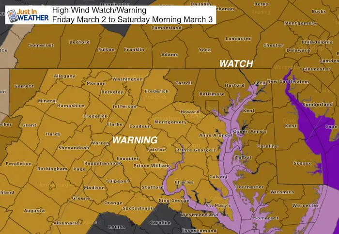
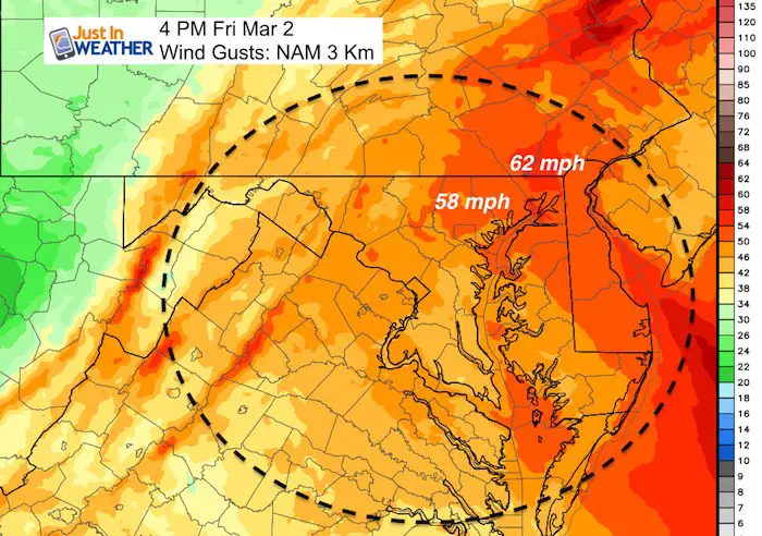
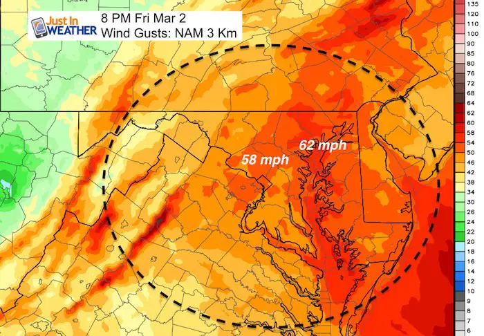
Today is the first day of meteorological spring and we have a very strong storm developing. Perhaps the full moon is also helping to enhance the pull into this event as I have theorized many times before. Regardless, there is a tremendous amount of energy about to be unleashed in the form of rain, some snow, and very high winds. A High Wind Warning has replaced some of the Watch areas and I expect that will continue to spread as we get closer to the event. Our entire area will feel the pressure gradient of the coastal storm which will result in steady winds of 40 mph and gusts to 60 mph.
This tropical storm force wind flow interacting with trees and soggy soil are likely to take many down along with power lines. Plan now for power outages. I am restocking fuel for my generator and reloading batteries. If you are traveling, there will be restrictions on area bridges and planes are likely to be delayed or grounded. If you do fly, there will be A LOT of turbulence!
See the latest wind maps and rain/snow timeline below. Yes, some snow will mix in Friday morning.
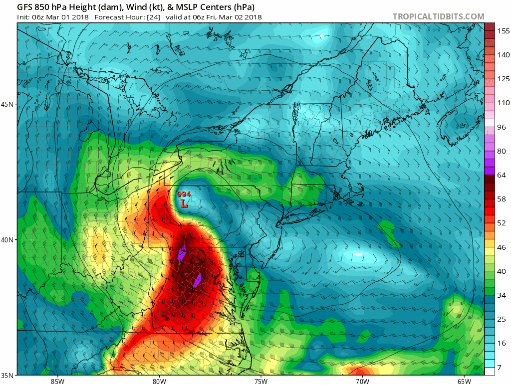
Here is s look at the 850mb Wind Flow. This is about 5,000 Ft above the ground and shows the true intensity of the storm a cloud level.
Stats For March 1
Average High: 49ºF
Record High: 80ºF in 1972
Average Low: 29ºF
*Former Record Low: 11ºF in 1980
Snow Record: 6.0″ in 1952
Seasonal Snow To Date (at BWI): 8.7″
Sunrise: 6:39 AM
Sunset 5:58 PM
*Daylight = 2:32 longer than yesterday
*Bay Water Temperature = 43ºF at Thomas Pt. Light House
Keep In Touch Every Day
Click here to sign up for email alerts…. Just in case you don’t get the post on your social media feed
Storm Set Up
Rain Timeline Today
Note: High Temperatures will reach the 50s today, but we all get rain by afternoon
—> slider
[metaslider id=59066]
Friday: Rain and Snow
—> slider
[metaslider id=59049]
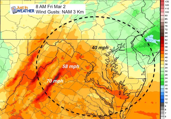
Winds Friday:
They will increase through the afternoon and evening
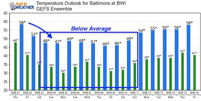
Temperature Outlook
Please share your thoughts, best weather pics/video, or just keep in touch via social media
-
Facebook: Justin Berk, Meteorologist
-
Twitter: @JustinWeather
-
Instagram: justinweather
Keep In Touch Every Day
Click here to sign up for email alerts…. Just in case you don’t get the post on your social media feed
FITF Gear

Snowstix- We Need You To Measure Snow Too
We are giving 10% of each sale to programs that benefit pediatric oncology patients.

 Get the award winning Kid Weather App I made with my oldest son and support our love for science, weather, and technology. Our 3 year anniversary of the release and our contribution to STEM education is this November. It has been downloaded in 60 countries, and works in both temperature scales. With your support we can expand on the fun introduction to science and real weather.
Keep In Touch All Winter
Click here to sign up for email alerts…. Just in case you don’t get the post on your social media feed
Also See:
My Winter Outlook 2017-2018 for more snow
La Nina Formed: What it could mean to our winter
NOAA Winter Outlook: Not The Best But Not The Worst For Snow
Two Farmers Almanacs Winter 2018 Outlooks
Winter Weather Folkore: Suggestions from Animals and Crops
First Frost and Freeze Dates For Maryland (southern PA and northern VA)
My Preliminary Winter Outlook Notes
Low Snow Winters In Baltimore: To Repeat Or Not Repeat
NOAA Ranks Blizzard 2016 4th Worst Snowstorm On Record
Blizzard 2016 Record Top Snowstorm: Area Totals
Extreme Weather of 2015 balanced out on both ends