Wednesday February 14 2018
Happy Valentines Day ❤️ We are in for a wild ride that includes temperatures near 70ºF Thursday and then snow on Saturday. I said winter wasn’t done and today is the day to show off your love of snow. Wear your L❄️VE shirts and get a photo solo or with your loved ones. Please look for my post about it on Facebook this afternoon around 2:14 PM and then share your photo so we can share the love. Your support has helped raise over $5,000 for the pediatric oncology wellness program Shannon and I are building. THANK YOU!
Weather Update: Please read closely, we have a lot of changes over the next few days.
Stats For February 14
Trivia: Today is the first day of the year that Baltimore has sunrise BEFORE 7 AM
Normal High: 45ºF
Record High: 70ºF in 1949
Normal Low: 26ºF
*Former Record Low: -2ºF in 1979
Snow Record: 4.0″ in 1986
Seasonal Snow To Date (at BWI): 6.5″
Sunrise: 6:59 AM
Sunset 5:42 PM
*Daylight = 2:19 longer than yesterday
*Bay Water Temperature = 37ºF at Thomas Pt. Light House
Keep In Touch All Winter
Click here to sign up for email alerts…. Just in case you don’t get the post on your social media feed
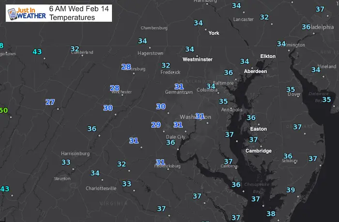
This Morning
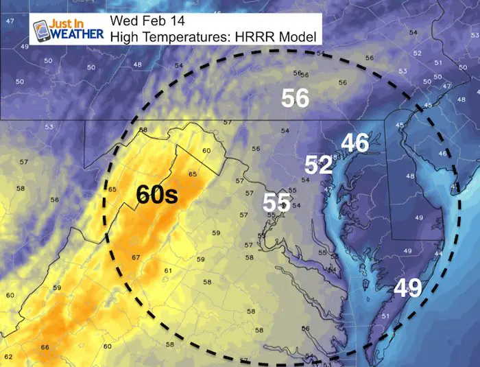
Mild Afternoon
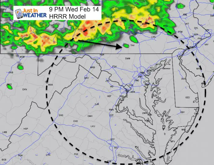
Showers Tonight
If you have dinner plans, consider this if you plan to be out after 8 PM
L❄️VE Snow ❤️
Multiple Styles: Ladies Performance, Unisex, Kids, and two types of Hoodies
My Fiancée Shannon is showing off her design for our L❄️VE Shirt. Proceeds help the start-up of our new program for Pediatric Oncology Patients. The big announcement is just two weeks away. Click here or on the photo to see more…
Winter weather will return soon….
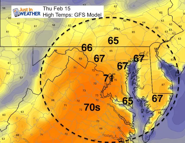
Thursday
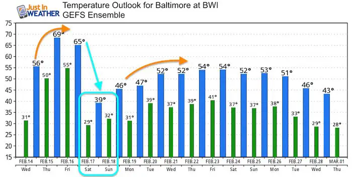
Warmest day of the week! There spread on the models still puts metro Baltimore to 70ºF within the margin of error. It will be more than 20 degrees above average!
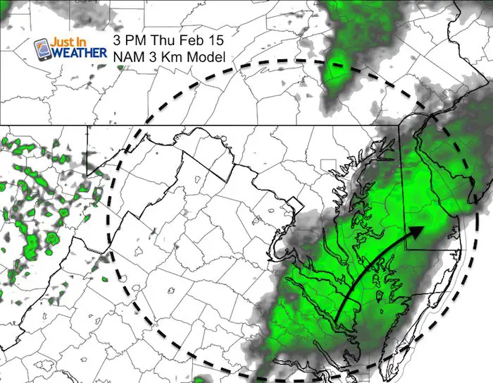
More rain showers developing around the low Chesapeake Bay
Friday
Rain in the morning
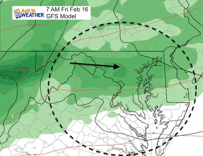
Weekend: Winter Returns
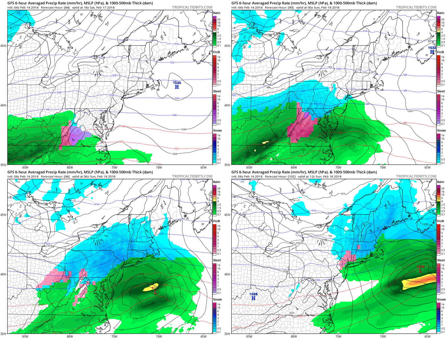
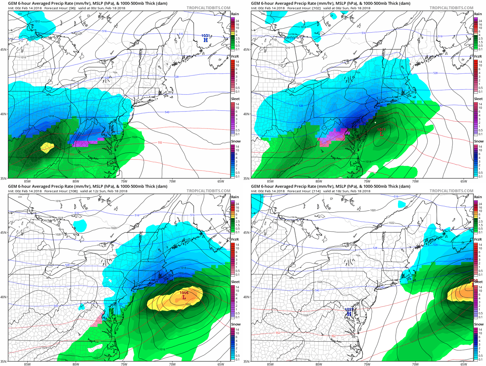
This is a storm that models have only caught on to in the past 24 to 36 hours. It is based on the front returning farther north and just barely tapping into the brief bought of cold air in place. Considering the model accuracy this winter, I do not believe we can lock into ‘amounts’ at this time since we need to firm up the precise track and freezing line.
Note: The track gives us a southeast wind, which would normally bring in warmer air to metro/I-95 locations. That needs to be factored in before promising snow totals. See the animation below.
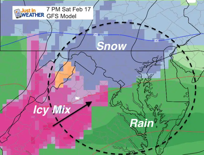
GFS Model Animation
Canadian Model Animation
This is a little colder than the GFS output.
Temperature Outlook
Please share your thoughts, best weather pics/video, or just keep in touch via social media
-
Facebook: Justin Berk, Meteorologist
-
Twitter: @JustinWeather
-
Instagram: justinweather
Keep In Touch All Winter
Click here to sign up for email alerts…. Just in case you don’t get the post on your social media feed
 Get the award winning Kid Weather App I made with my oldest son and support our love for science, weather, and technology. Our 3 year anniversary of the release and our contribution to STEM education is this November. It has been downloaded in 60 countries, and works in both temperature scales. With your support we can expand on the fun introduction to science and real weather.
Snowstix- We Need You To Measure Snow Too
We are giving 10% of each sale to programs that benefit pediatric oncology patients.
FITF Gear
Keep In Touch All Winter
Click here to sign up for email alerts…. Just in case you don’t get the post on your social media feed
Also See:
My Winter Outlook 2017-2018 for more snow
La Nina Formed: What it could mean to our winter
NOAA Winter Outlook: Not The Best But Not The Worst For Snow
Two Farmers Almanacs Winter 2018 Outlooks
Winter Weather Folkore: Suggestions from Animals and Crops
First Frost and Freeze Dates For Maryland (southern PA and northern VA)
My Preliminary Winter Outlook Notes
Low Snow Winters In Baltimore: To Repeat Or Not Repeat
NOAA Ranks Blizzard 2016 4th Worst Snowstorm On Record

