 Monday February 12 2018
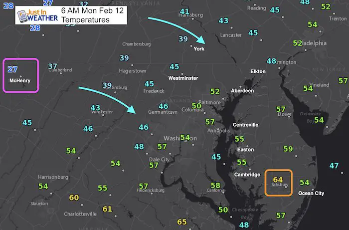
This pattern is the gift that keeps on giving. The rain never really departed and we still have it this morning splitting our region in half from around I-95 and eastward. The warm air is with us as well to start the day but it will not stay as the cooler temperatures are following the rains departure. So, dress like its a normal February day even though this morning is warm. We’ve already hit our high temperatures.
This will be our first week of the year without a nearby winter weather related school delay. Valentines Day will be seasonably chilly just in time for you to show off your Love Snow shirts. But, the outlook for the majority of the next two weeks is warm, winter is not done. But it may feel like it when you see the temperature outlook. The pendulum may very well swing back out way in March. But in the meantime we can ease up on the cabin fever.
Stats For February 12
Trivia: Today is the anniversary of one of our largest snowstorms. On Feb 11, 1983- Baltimore recorded 22.8 inches of snow
Normal High: 44ºF
Record High: 73ºF in 1999
Normal Low: 26ºF
*Former Record Low: +5ºF in 1899
Snow Record: 9.6″ in 2006
Seasonal Snow To Date (at BWI): 6.5″
Sunrise: 7:01 AM
Sunset 5:39 PM
*Daylight = 2:19 longer than yesterday
*Bay Water Temperature = 37ºF at Thomas Pt. Light House
Keep In Touch All Winter
Click here to sign up for email alerts…. Just in case you don’t get the post on your social media feed
Weather Set Up
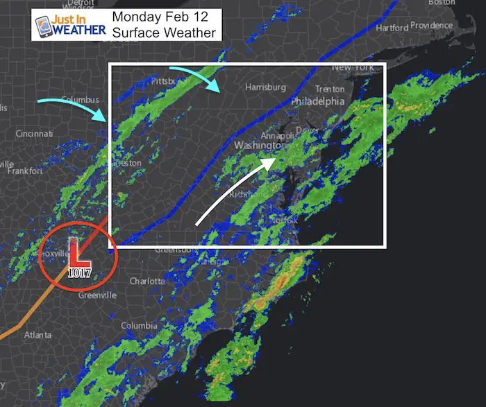
Rain Timeline
—> slider
[metaslider id=57928]
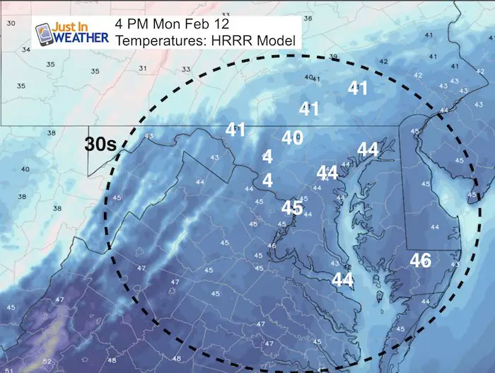
Afternoon Temperatures
Remember, we have already hit our highs this morning…
L❄️VE Snow ❤️
Multiple Styles: Ladies Performance, Unisex, Kids, and two types of Hoodies
My Fiancée Shannon is showing off her design for our L❄️VE Shirt. Proceeds help the start-up of our new program for Pediatric Oncology Patients. The big announcement is just two weeks away. Click here or on the photo to see more…
Winter weather will return soon….

Storm Animation:
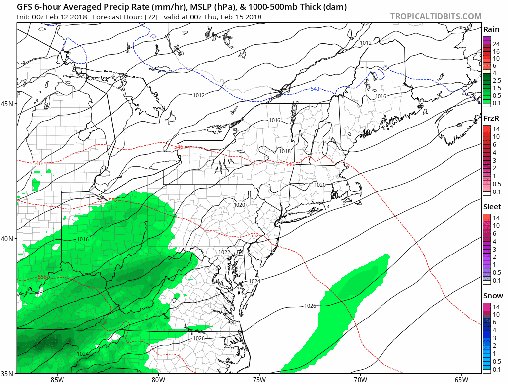
Another rain event later this week: Wednesday evening through Friday morning. A similar set up but should be less rain and flooding. Next weekend appears to be dry and mild.
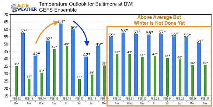
Temperature Outlook
The majority of the next two weeks will be above average, but I do not believe that winter is done. The swing back to the cold side of the jet is likely in March
Please share your thoughts, best weather pics/video, or just keep in touch via social media
-
Facebook: Justin Berk, Meteorologist
-
Twitter: @JustinWeather
-
Instagram: justinweather
Keep In Touch All Winter
Click here to sign up for email alerts…. Just in case you don’t get the post on your social media feed
 Get the award winning Kid Weather App I made with my oldest son and support our love for science, weather, and technology. Our 3 year anniversary of the release and our contribution to STEM education is this November. It has been downloaded in 60 countries, and works in both temperature scales. With your support we can expand on the fun introduction to science and real weather.
Snowstix- We Need You To Measure Snow Too
We are giving 10% of each sale to programs that benefit pediatric oncology patients.

FITF Gear

Keep In Touch All Winter
Click here to sign up for email alerts…. Just in case you don’t get the post on your social media feed
Also See:
My Winter Outlook 2017-2018 for more snow
La Nina Formed: What it could mean to our winter
NOAA Winter Outlook: Not The Best But Not The Worst For Snow
Two Farmers Almanacs Winter 2018 Outlooks
Winter Weather Folkore: Suggestions from Animals and Crops
First Frost and Freeze Dates For Maryland (southern PA and northern VA)
My Preliminary Winter Outlook Notes
Low Snow Winters In Baltimore: To Repeat Or Not Repeat
NOAA Ranks Blizzard 2016 4th Worst Snowstorm On Record