 Saturday February 10 2018
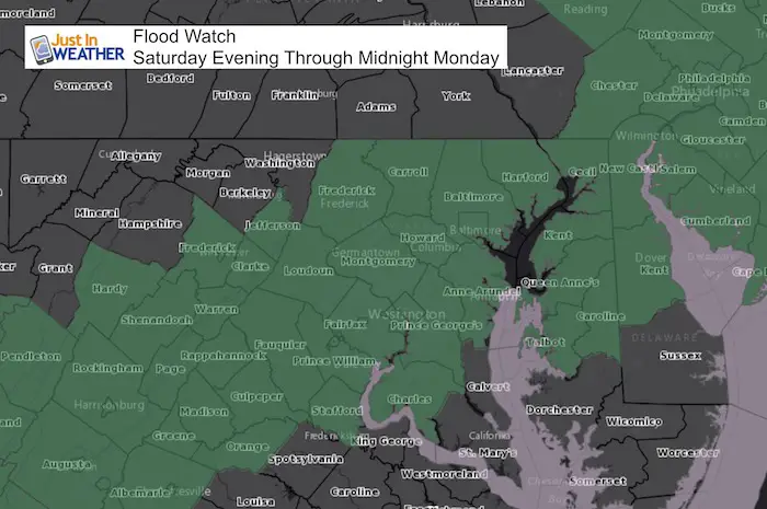
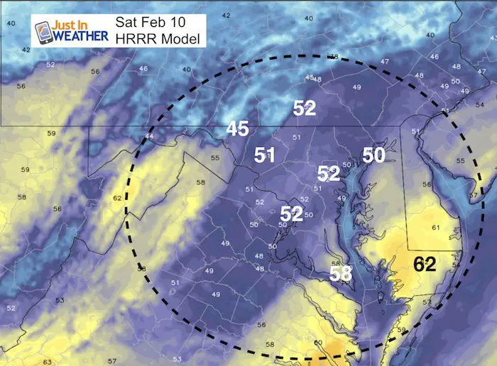
A Flood Watch has been posted for much of our region starting Saturday evening and going through midnight tomorrow night. The storm on the way is a warm one with all rain, so a bit sad for snow lovers. But this will be beneficial to the severe drought conditions we have. The storm has adjusted the track a little west, to send even more rain. This may be more rain for the Baltimore area than we have seen since late last July, which could push into the 2 to 4 inch range.
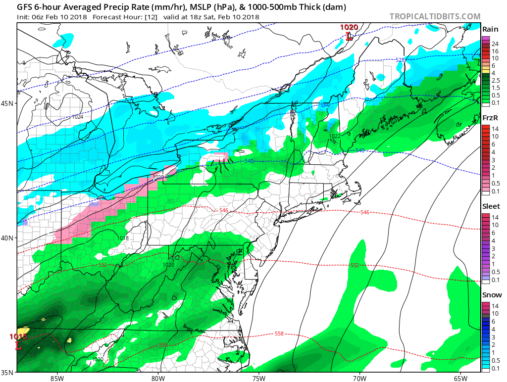
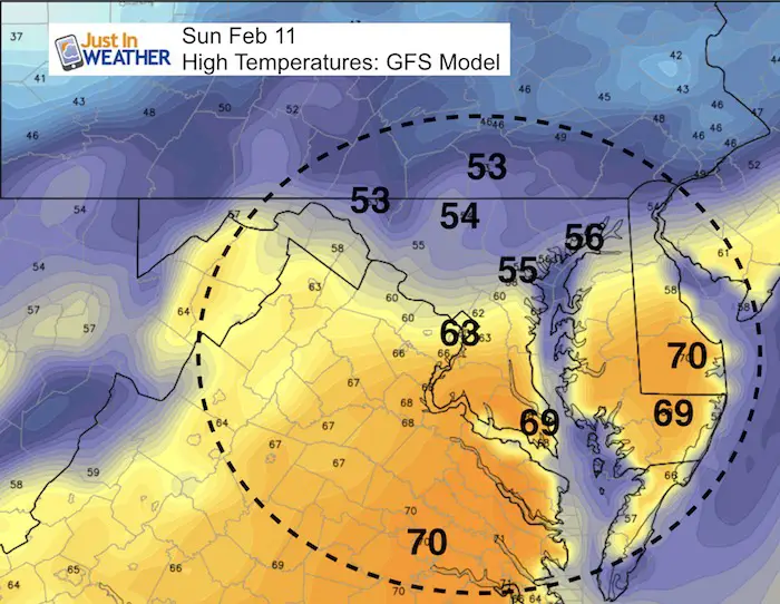
The there thing about this storm is the warm air. Maryland will be the dividing line for the surge of very warm air and parts of the state will be close to 70ºF in Sunday. That is no joke…. but Baltimore and norther areas are likely just miss that as we are in line for the heavy rain train! In fact, we could possibly have some thunder with the downpours on Sunday.
Stats For February 10
Normal High: 44ºF
Record High: 66ºF in 1966
Normal Low: 26ºF
*Former Record Low: -7ºF in 1899
Snow Record: 5.0″ in 1965
Seasonal Snow To Date (at BWI): 6.5″
Sunrise: 7:04 AM
Sunset 5:38 PM
*Daylight = 2:17 longer than yesterday
*Bay Water Temperature = 34ºF at Thomas Pt. Light House
Keep In Touch All Winter
Click here to sign up for email alerts…. Just in case you don’t get the post on your social media feed
Rain Today
—-> slider: Radar Simulation
Moderate rain will move in this afternoon. This is a little faster than first thought… Heavier rain will dominate Sunday!
Storm Animation
Moderate bands of rain today. The heaviest rain will be on Sunday
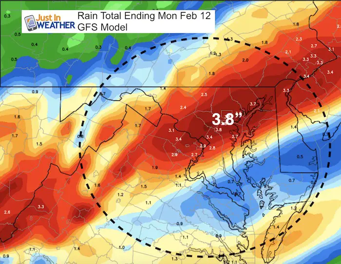
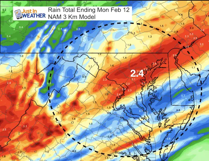
Rain Totals
The last time Baltimore has had this much rain was…
3.94″ on July 28 to 29 2017
Comparing Two Model Predictions
Drought Reminder

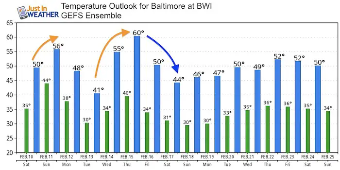
Temperatures
Highs Today
Sunday
Outlook
We are NOT done with winter yet. I believe the warm surge with this storm… and perhaps again next week will be replaced by one more cold snap as we head into March. Stay tuned and keep you FITF.
L❄️Ve Snow ❤️
We’ve added KIDS SIZES and HOODIES
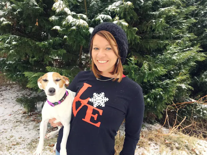
My Fiancée Shannon is showing off her design for our L❄️VE Shirt. Proceeds help the start-up of our new program for Pediatric Oncology Patients. The big announcement is just two weeks away. Click here or on the photo to see more…
Winter weather will return soon….
Please share your thoughts, best weather pics/video, or just keep in touch via social media
-
Facebook: Justin Berk, Meteorologist
-
Twitter: @JustinWeather
-
Instagram: justinweather
Keep In Touch All Winter
Click here to sign up for email alerts…. Just in case you don’t get the post on your social media feed
 Get the award winning Kid Weather App I made with my oldest son and support our love for science, weather, and technology. Our 3 year anniversary of the release and our contribution to STEM education is this November. It has been downloaded in 60 countries, and works in both temperature scales. With your support we can expand on the fun introduction to science and real weather.
Snowstix- We Need You To Measure Snow Too
We are giving 10% of each sale to programs that benefit pediatric oncology patients.

FITF Gear

Keep In Touch All Winter
Click here to sign up for email alerts…. Just in case you don’t get the post on your social media feed
Also See:
My Winter Outlook 2017-2018 for more snow
La Nina Formed: What it could mean to our winter
NOAA Winter Outlook: Not The Best But Not The Worst For Snow
Two Farmers Almanacs Winter 2018 Outlooks
Winter Weather Folkore: Suggestions from Animals and Crops
First Frost and Freeze Dates For Maryland (southern PA and northern VA)
My Preliminary Winter Outlook Notes
Low Snow Winters In Baltimore: To Repeat Or Not Repeat
NOAA Ranks Blizzard 2016 4th Worst Snowstorm On Record