 Thursday February 8 2018
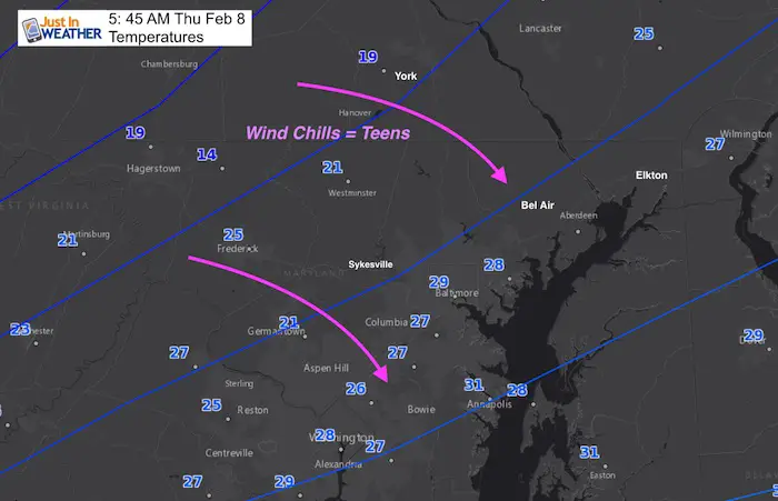
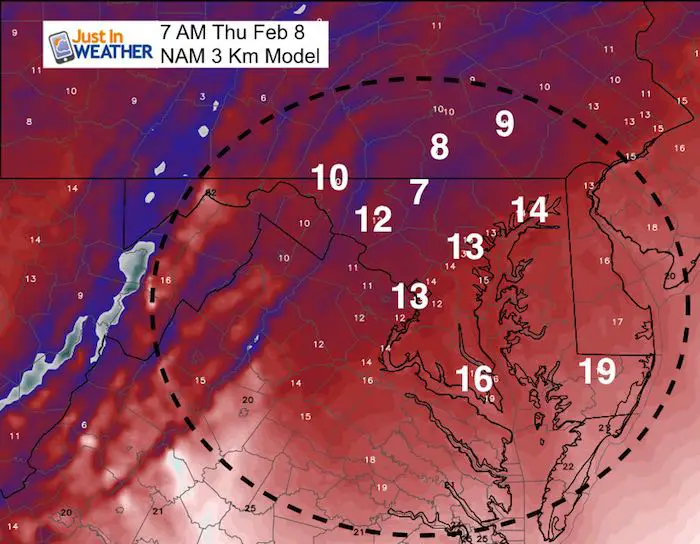
The cold air made a return overnight, which has led to refreezing. But the timing and local set up really will determine if you have ice and a need for school delays. Temperatures dropped below freezing before midnight in many places that had leftover ice from earlier yesterday or just wet ground. But in Baltimore and south, the freezing air arrived a littler later between 1 and 2 AM. That allowed the pavement much of those urban areas to dry out just enough to limit ice formation.
This really is a hyper local decision, but I would suggest the worst problems are in the places that had their ice linger until noon or later yesterday. When you do head out, dress for mid chills in the teens.
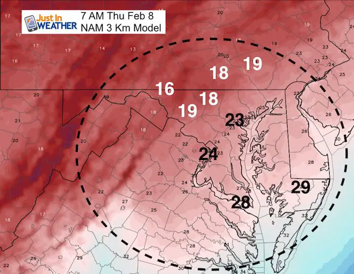
Colder air is spreading south quickly so the numbers shown on the map above will be changing by sunrise.
Below is a look at today’s break down, and then the set up for heavy rain this weekend. The really wet day will be Sunday and it will make a dent in our drought.
Stats For February 8
Normal High: 43ºF
Record High: 72ºF in 2017
Normal Low: 26ºF
*Former Record Low: -1ºF in 1967
Snow Record: 6.3″ in 1974
Seasonal Snow To Date (at BWI): 6.5″
Sunrise: 7:06 AM
Sunset 5:36 PM
*Daylight = 2:16 longer than yesterday
*Bay Water Temperature = 34ºF at Thomas Pt. Light House
Keep In Touch All Winter
Click here to sign up for email alerts…. Just in case you don’t get the post on your social media feed
L❄️Ve Snow ❤️
Order by 4 PM TODAY to promise delivery before Valentines Day!
On Feb 14 we want everyone to wear and take a photo to show you care ?
We’ve added KIDS SIZES and HOODIES
My Fiancée Shannon is showing off her design for our L❄️VE Shirt. Proceeds help the start-up of our new program for Pediatric Oncology Patients. The big announcement is just two weeks away. Click here or on the photo to see more…
Back To The Weather…
This Morning’s Chill
Temperatures
Wind Speed
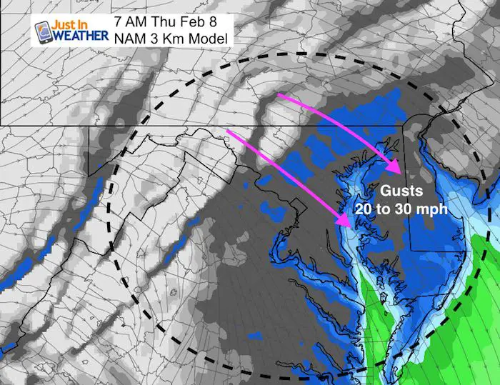
Wind Chill- This is what it will FEEL LIKE
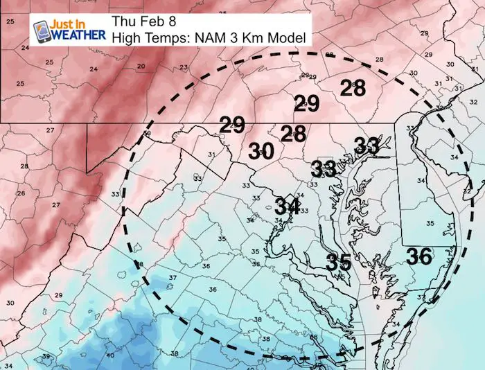
This Afternoon
Just above freezing for urban areas and south of I-95. But even in the colder north, some sun should help thaw out frozen pavement.
Jumping To The Weekend
The next storm will be warmer and all rain. At this point, clouds will increase on Saturday and bring in showers from the south by evening. The main bulk of rain will be Sunday, and it will be heavy at times…
Another system will follow Monday night and Tuesday.

Rainfall Potential
Central Maryland (Between Frederick along the PA line to DE line) and southward are on pace to get between 1 and 3 inches of rain through next week. More will fall south of Annapolis.
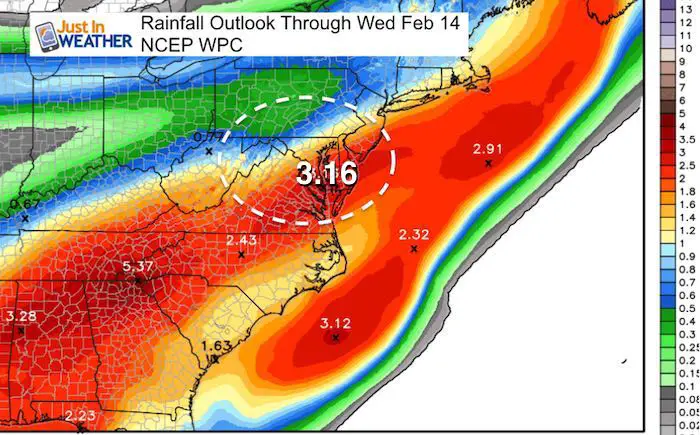
Also See: Severe Drought in Maryland

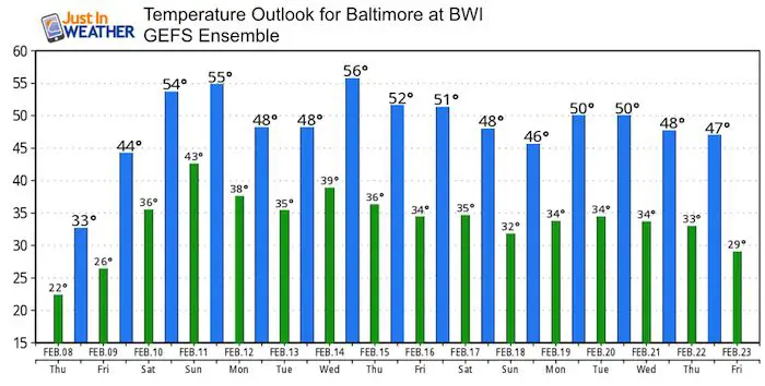
Temperature Outlook
We will have a mild pattern for the majority of the next 10 days. This includes Valentines Day. But our average temperature does warm to 45ºF mid month, so only a few days markedly above that. The pattern does have a chance to send in more arctic air in March. Stand by snow lovers. Winter is not done yet. FITF
Please share your thoughts, best weather pics/video, or just keep in touch via social media
-
Facebook: Justin Berk, Meteorologist
-
Twitter: @JustinWeather
-
Instagram: justinweather
Keep In Touch All Winter
Click here to sign up for email alerts…. Just in case you don’t get the post on your social media feed
 Get the award winning Kid Weather App I made with my oldest son and support our love for science, weather, and technology. Our 3 year anniversary of the release and our contribution to STEM education is this November. It has been downloaded in 60 countries, and works in both temperature scales. With your support we can expand on the fun introduction to science and real weather.
Snowstix- We Need You To Measure Snow Too
We are giving 10% of each sale to programs that benefit pediatric oncology patients.

FITF Gear

Keep In Touch All Winter
Click here to sign up for email alerts…. Just in case you don’t get the post on your social media feed
Also See:
My Winter Outlook 2017-2018 for more snow
La Nina Formed: What it could mean to our winter
NOAA Winter Outlook: Not The Best But Not The Worst For Snow
Two Farmers Almanacs Winter 2018 Outlooks
Winter Weather Folkore: Suggestions from Animals and Crops
First Frost and Freeze Dates For Maryland (southern PA and northern VA)
My Preliminary Winter Outlook Notes
Low Snow Winters In Baltimore: To Repeat Or Not Repeat
NOAA Ranks Blizzard 2016 4th Worst Snowstorm On Record