 Tuesday January 30 2018
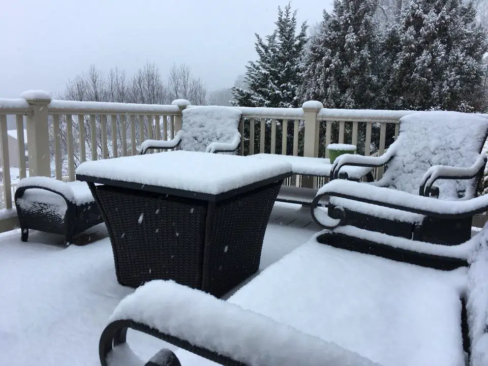
The snow event this morning arrived on schedule before sunrise and led to an impact as expect for northern and western suburbs. This may not have seemed like anything worth mentioning, but school delays and closings were the result of 1 to 3 inch snowfall. Above was the view on my back deck around sunrise with 2 inches of snow and stickage on the roads. Below is a look at where the snow fell based on National Weather Service spotters.Please compare to my forecast and grade it based on if you did get what you expected. I hope I made my point clear last night that the warm ground and delay of freezing temperatures would make this a non-issue for half of our area. But north and west of Baltimore is where some places actually over achieved. Here’s a look:
My SnowCast
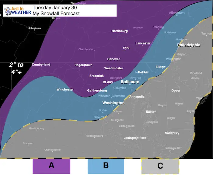
- A: Snow 1/2″ to 2″
- Best chance for roads to get icy. This area will be colder with a little more snow allowing for a better opportunity to freeze the ground and get stickage. The hills and valleys will range in totals a bit. If there are school delays, it is more likely in this zone.
- B: Snow Dusting to 1″
- Marginal stickage on roads… Many will be wet, but some including elevated bridges and overpasses will briefly get slick between 6 and 9 AM.
- This area will have the colder air arrive a little later after the snow arrives. Flakes will be wasted to more melting. This region has a lower chance for school delays, but any speeding up of the timing will get more snow to fall in the dark hours and possibly slick up the ground sooner.
- C: Snow Dusting On The Grass
- This area is most likely to have wet roads.
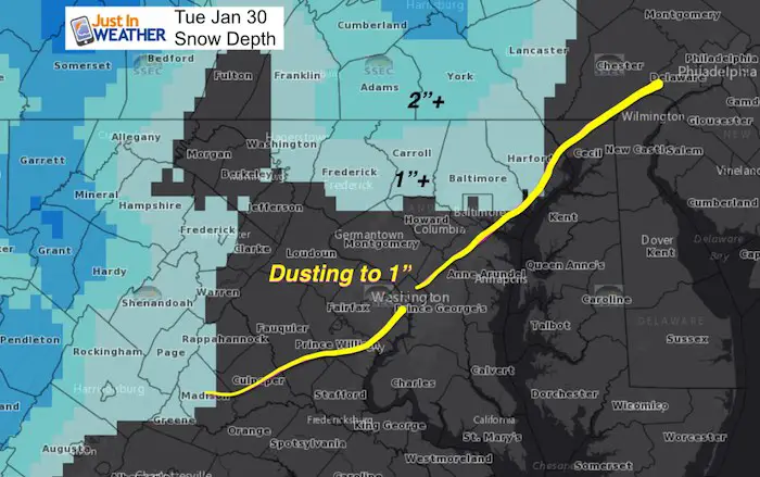
National Weather Service Snow Depth Today
The initial look matches well, but here is what I got wrong:
- Some places in the mountains were void of snow
- Many places east of I-95 didn’t get any of the snow to stick. But flakes did fall. This region was not expecting to get more than snow on the grass.
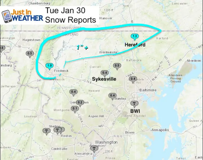
Closer Look
Overachieving in York County. There as a region that got between 2 and 3 inches from Hanover, Fawn Grove, and Loganville. Some schools here closed.

Maryland
LOCATION              24 HOUR     TIME/DATE   COMMENTS
                     SNOWFALL           OF
                     /INCHES/   MEASUREMENT

MARYLAND

..Anne Arundel County... Bwi Airport T 655 AM 1/30 Airport

...Allegany County...
   Frostburg 2 COOP       0.8   700 AM  1/30  Co-Op Observer

...Baltimore County...
   Rosedale 1 SSE         0.7   730 AM  1/30  HADS
   Resiterstown.          0.5
   Long Green             0.5   700 AM  1/30  CoCoRaHS
   Towson                 0.2   830 AM  1/30  CoCoRaHS
   Kingsville 1 E         0.1   700 AM  1/30  CoCoRaHS

...Carroll County...
   Gamber                 0.7   700 AM  1/30  CoCoRaHS
   Taneytown 3 NE         0.5   730 AM  1/30  CoCoRaHS
   Sykesville 3 NE        0.4   700 AM  1/30  CoCoRaHS
   Mount Airy  SE         0.3   700 AM  1/30  CoCoRaHS

...Frederick County...
   Thurmont 3 N           1.0   700 AM  1/30  CoCoRaHS
   Thurmont               0.3   800 AM  1/30  CoCoRaHS

...Harford County...
   Norrisville            0.5   630 AM  1/30  CoCoRaHS
   Bel Air 1 W            0.3   700 AM  1/30  CoCoRaHS

...Howard County...
   Columbia 2 N           0.4   700 AM  1/30  CoCoRaHS
   Columbia 1 N           0.3   700 AM  1/30  CoCoRaHS
   Gaither 1 ESE          0.3   700 AM  1/30  CoCoRaHS

...Montgomery County...
   Damascus 3 Ssw Coop    0.4   700 AM  1/30  Co-Op Observer
   Montgomery Village     0.3   700 AM  1/30  CoCoRaHS
   Clarksburg 2 E         0.2   600 AM  1/30  CoCoRaHS
   Olney 1 SE             0.2   700 AM  1/30  CoCoRaHS
   Norbeck 1 ESE          0.1   700 AM  1/30  CoCoRaHS
   Damascus 2 SSE         0.1   630 AM  1/30  CoCoRaHS
   Potomac                0.1   700 AM  1/30  CoCoRaHS

...Washington County...
   Hagerstown             1.0   700 AM  1/30  CoCoRaHS
   Halfway                0.5   600 AM  1/30  CoCoRaHS
Want More Snow?
We may have a repeat in Friday morning and a larger event on Sunday/Monday. I will have an update this evening. FITF
Please share your thoughts, best weather pics/video, or just keep in touch via social media
-
Facebook: Justin Berk, Meteorologist
-
Twitter: @JustinWeather
-
Instagram: justinweather
Snowstix- We Need You To Measure Snow Too
We are giving 10% of each sale to programs that benefit pediatric oncology patients.

FITF Gear

 Get the award winning Kid Weather App I made with my oldest son and support our love for science, weather, and technology. Our 3 year anniversary of the release and our contribution to STEM education is this November. It has been downloaded in 60 countries, and works in both temperature scales. With your support we can expand on the fun introduction to science and real weather.
Keep In Touch All Winter
Click here to sign up for email alerts…. Just in case you don’t get the post on your social media feed
Also See:
My Winter Outlook 2017-2018 for more snow
La Nina Formed: What it could mean to our winter
NOAA Winter Outlook: Not The Best But Not The Worst For Snow
Two Farmers Almanacs Winter 2018 Outlooks
Winter Weather Folkore: Suggestions from Animals and Crops
First Frost and Freeze Dates For Maryland (southern PA and northern VA)
My Preliminary Winter Outlook Notes
Low Snow Winters In Baltimore: To Repeat Or Not Repeat
NOAA Ranks Blizzard 2016 4th Worst Snowstorm On Record