 Wednesday January 24 2018
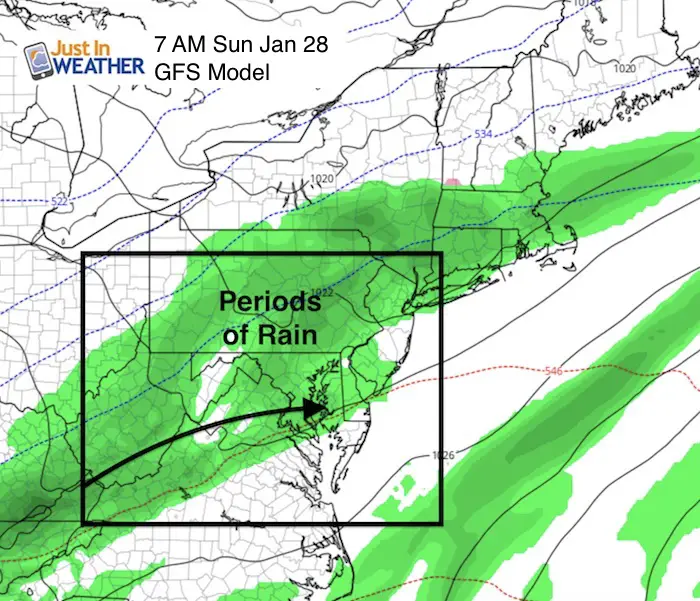
After few days in the 60s, we have colder winds today that bring back the reality of late January weather. Near normal temperatures will be with us for a few days, then warm back this weekend. If you are making plans, Saturday will be the day to be outside as rain is expected Sunday. Then we set out sights on next week as snowhounds are anxiously waiting for any hint of winter weather returning. We have that on the way.
Stats For January 24
Normal High: 41ºF
Record High: 74ºF in 1967
Normal Low: 24ºF
*Former Record Low: +1ºF in 1963
Snow Record: 5.8″ in 1940
Seasonal Snow To Date (at BWI): 6.5″
Sunrise: 7:19 AM
Sunset 5:17 PM
*Daylight = 1:49 longer than yesterday
*Bay Water Temperature = 34ºF at Thomas Pt. Light House
Keep In Touch All Winter
Click here to sign up for email alerts…. Just in case you don’t get the post on your social media feed
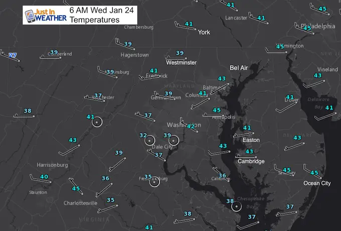
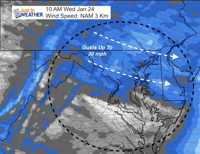
Today
Windy Morning
High Temperatures 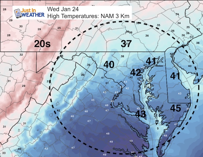
Weekend Outlook
Rainy Sunday
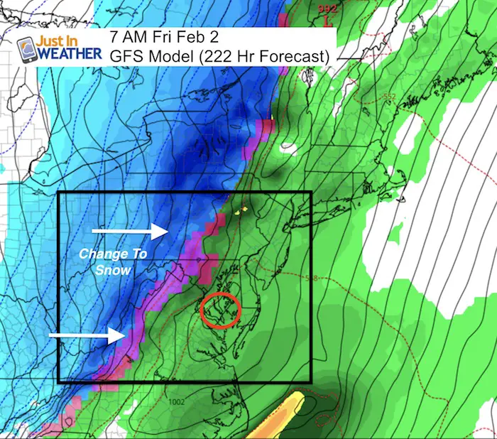
Groundhog Day Storm?
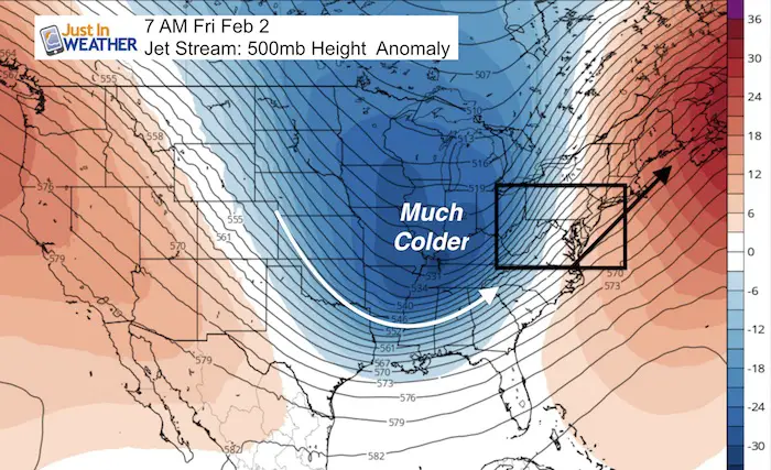
A coastal storm expected on Groudhog Day has shown up considerably for a few days bringing a rain transitioning to snow event. While I DO NOT like to show surface maps more than 1 week away, I wanted to share this for reference before taking this a little more seriously this in a few days. This is the surface reflection of the return to the colder pattern in the Jet Stream
Pattern Change In February
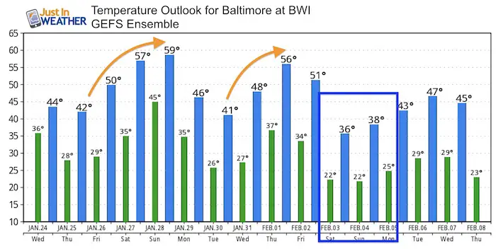
Temperature Outlook
The last few days in this outlook case be taken with a grain of salt. I so not trust the modeling that far out, and when it is unsure the trend display close to normal.
May The Flakes Be With You- Limited Edition Shirt
A Portion of the proceeds will go to Integrated Wellness programs for Pediatric Oncology Patients

FITF Gear

Please share your thoughts, best weather pics/video, or just keep in touch via social media
-
Facebook: Justin Berk, Meteorologist
-
Twitter: @JustinWeather
-
Instagram: justinweather
Snowstix- We Need You To Measure Snow Too
We are giving 10% of each sale to programs that benefit pediatric oncology patients.

 Get the award winning Kid Weather App I made with my oldest son and support our love for science, weather, and technology. Our 3 year anniversary of the release and our contribution to STEM education is this November. It has been downloaded in 60 countries, and works in both temperature scales. With your support we can expand on the fun introduction to science and real weather.
Keep In Touch All Winter
Click here to sign up for email alerts…. Just in case you don’t get the post on your social media feed
Also See:
My Winter Outlook 2017-2018 for more snow
La Nina Formed: What it could mean to our winter
NOAA Winter Outlook: Not The Best But Not The Worst For Snow
Two Farmers Almanacs Winter 2018 Outlooks
Winter Weather Folkore: Suggestions from Animals and Crops
First Frost and Freeze Dates For Maryland (southern PA and northern VA)
My Preliminary Winter Outlook Notes
Low Snow Winters In Baltimore: To Repeat Or Not Repeat
NOAA Ranks Blizzard 2016 4th Worst Snowstorm On Record
Blizzard 2016 Record Top Snowstorm: Area Totals
Extreme Weather of 2015 balanced out on both ends