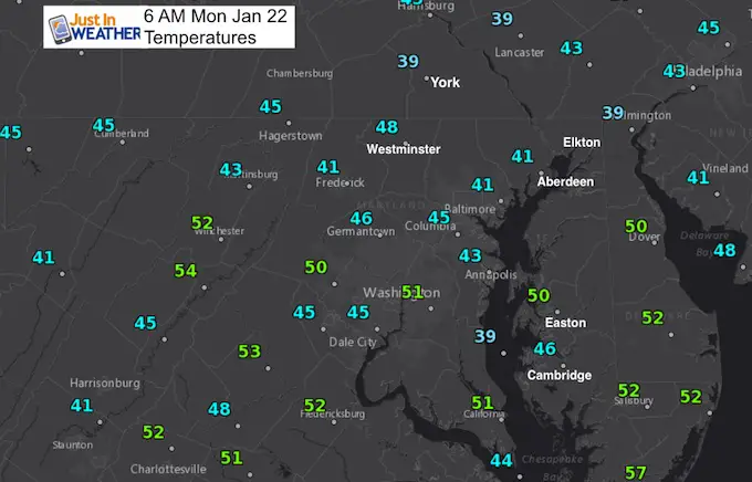
Monday January 22 2018
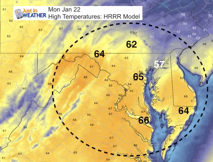
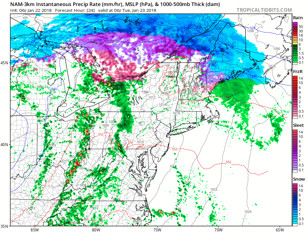
We are on the warm side of the storm track and will get warm air surging in ahead of rain. Most of today will be dry, but some sprinkles are possible later this afternoon. The main rain will arrive overnight and last through Tuesday when a few rumbles of thunder are possible. This will help to clean some of the salt off of cars and the roads. The main story will be the temperatures reaching the 60s, however more normal conditions will return mid week and snow back into western Maryland and mountain ski resorts. Our snow chances will have to wait at least another 10 days or so, but winter will come back in February.
Stats For January 22
Normal High: 41ºF
Record High: 69ºF in 1927
Normal Low: 24ºF
*Former Record Low: -7ºF in 1984
Snow Record: 12.3″ in 1987
Seasonal Snow To Date (at BWI): 6.5″
Sunrise: 7:21 AM
Sunset 5:16 PM
*Daylight = 1:45 longer than yesterday
*Bay Water Temperature = 33ºF at Thomas Pt. Light House
Keep In Touch All Winter
Click here to sign up for email alerts…. Just in case you don’t get the post on your social media feed
High Temperatures Today
Due to the wind direction, the coolest areas will be along the Bay and northern portions in Harford, Cecil, and Kent Counties.
Rainfall Animation
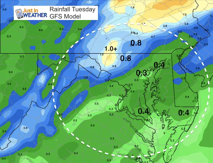
Rainfall Potential
Baltimore is 1.34″ below normal for this month! So we could use any precipitation! The bulk of the rain will fall along the mountains, but a decent push for a quarter to half an inch in much of central Maryland.
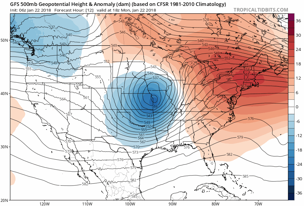
Jet Stream: Weather Trend
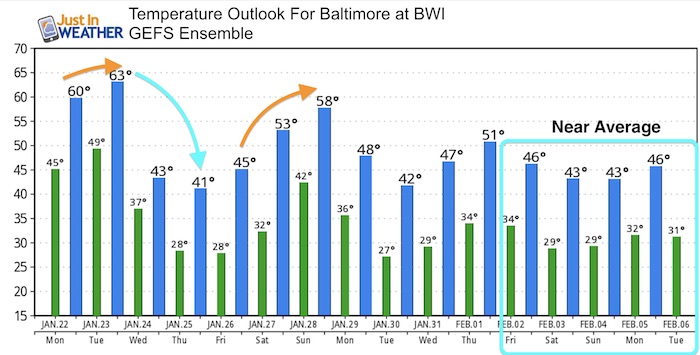
Friday and the weekend will warm up again, then the pattern appears to show long term cooler as we enter February. At least back to near normal… The longer range shows a stronger push of cold air back for the middle of next month that could be similar to how January began for us. There is hope winter lovers. FITF
Temperature Outlook
May The Flakes Be With You- Limited Edition Shirt
A Portion of the proceeds will go to Integrated Wellness programs for Pediatric Oncology Patients

FITF Gear

Please share your thoughts, best weather pics/video, or just keep in touch via social media
-
Facebook: Justin Berk, Meteorologist
-
Twitter: @JustinWeather
-
Instagram: justinweather
Snowstix- We Need You To Measure Snow Too
We are giving 10% of each sale to programs that benefit pediatric oncology patients.

 Get the award winning Kid Weather App I made with my oldest son and support our love for science, weather, and technology. Our 3 year anniversary of the release and our contribution to STEM education is this November. It has been downloaded in 60 countries, and works in both temperature scales. With your support we can expand on the fun introduction to science and real weather.
Keep In Touch All Winter
Click here to sign up for email alerts…. Just in case you don’t get the post on your social media feed
Also See:
My Winter Outlook 2017-2018 for more snow
La Nina Formed: What it could mean to our winter
NOAA Winter Outlook: Not The Best But Not The Worst For Snow
Two Farmers Almanacs Winter 2018 Outlooks
Winter Weather Folkore: Suggestions from Animals and Crops
First Frost and Freeze Dates For Maryland (southern PA and northern VA)
My Preliminary Winter Outlook Notes
Low Snow Winters In Baltimore: To Repeat Or Not Repeat
NOAA Ranks Blizzard 2016 4th Worst Snowstorm On Record
Blizzard 2016 Record Top Snowstorm: Area Totals
Extreme Weather of 2015 balanced out on both ends