 Friday January 19 2018
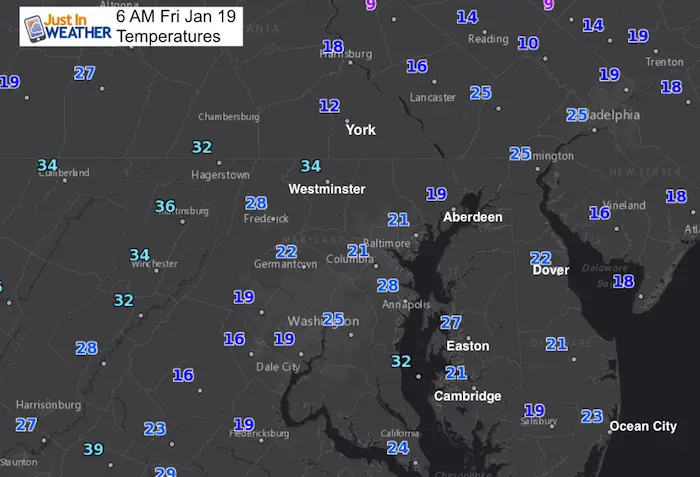
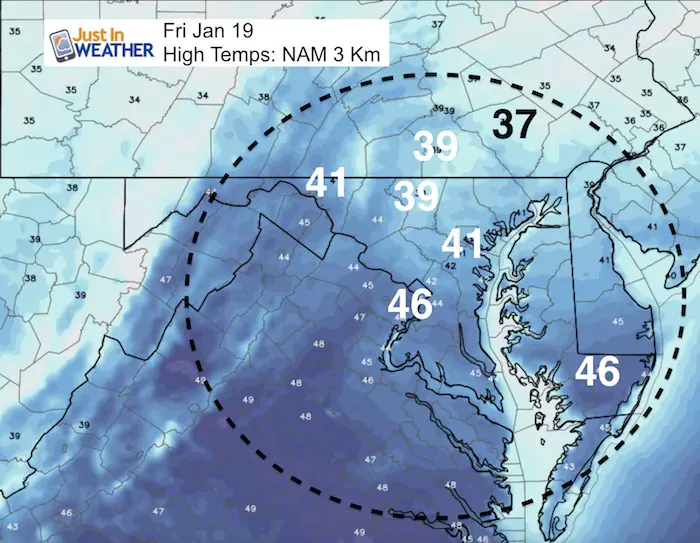
This morning is still cold and the day will remain chilly. High temperatures will be near average today, and then aim warmer into next week. We have a relative quiet pattern for a few days. While the jet stream relaxes, the next event will bring us rain, but winter is not done by any stretch. Just a break in the action to thaw out. Up to date, temperatures at BWI this January is running -6.3ºF… Below Average! This includes 8 days with high temperatures staying at or below 32ºF. We are due for a little thaw.
Stats For January 19
Normal High: 41ºF
Record High: 69ºF in 1951
Normal Low: 24ºF
*Former Record Low: -5ºF in 1994
Snow Record: 7.7″ in 1961
Seasonal Snow To Date (at BWI): 6.5″
Sunrise: 7:23 AM
Sunset 5:13 PM
*Daylight = 1:37 longer than yesterday
*Bay Water Temperature = 32ºF at Thomas Pt. Light House
Recap:
Snow Report for January 17 and Grade My Forecast
Keep In Touch All Winter
Click here to sign up for email alerts…. Just in case you don’t get the post on your social media feed
Today
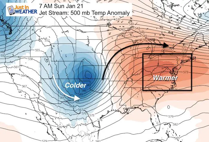
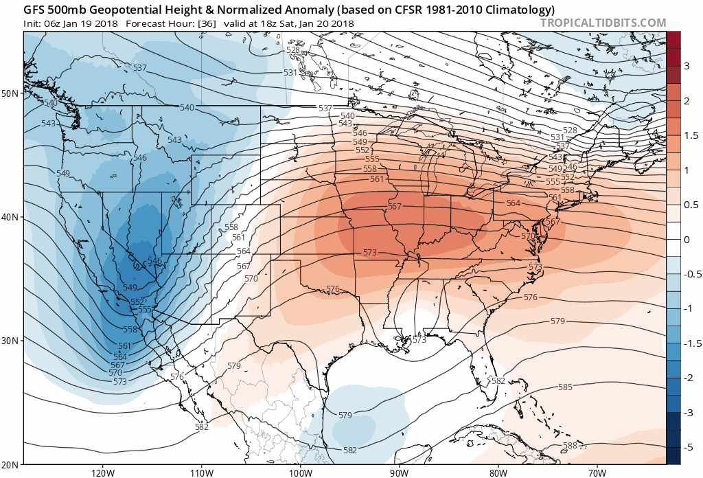
Jet Stream Flips
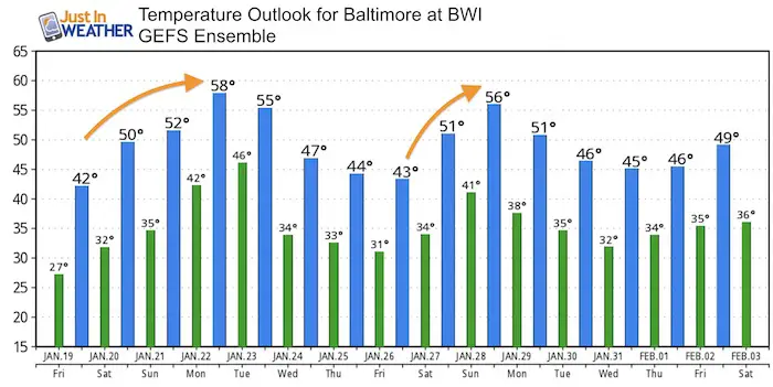
Temperature Outlook
Much like our last warm up, I think we could easily hit the 60s ahead of the rain next Monday.
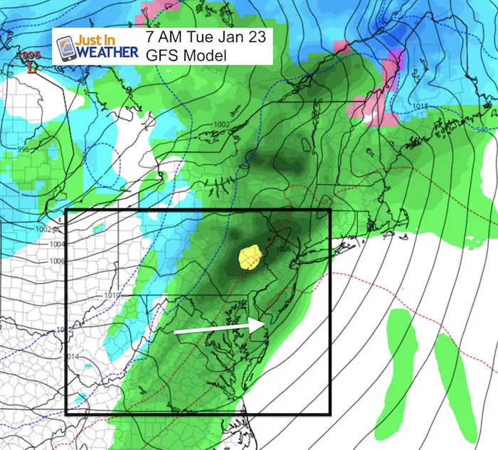
Tuesday: Rain With Next Event
Jet Stream Animation
The warm (orange) and cold (blue) should fluctuate and will over the next 10 days. There is a hint at a storm finishing out January that will start as rain and end with snow. I do not believe in showing surface maps more than 1 week away for most events as it is likely to change. Just keep January 29 to 31 in mind for some transition.
May The Flakes Be With You- Limited Edition Shirt
A Portion of the proceeds will go to Integrated Wellness programs for Pediatric Oncology Patients

FITF Gear

Please share your thoughts, best weather pics/video, or just keep in touch via social media
-
Facebook: Justin Berk, Meteorologist
-
Twitter: @JustinWeather
-
Instagram: justinweather
Snowstix- We Need You To Measure Snow Too
We are giving 10% of each sale to programs that benefit pediatric oncology patients.

 Get the award winning Kid Weather App I made with my oldest son and support our love for science, weather, and technology. Our 3 year anniversary of the release and our contribution to STEM education is this November. It has been downloaded in 60 countries, and works in both temperature scales. With your support we can expand on the fun introduction to science and real weather.
Keep In Touch All Winter
Click here to sign up for email alerts…. Just in case you don’t get the post on your social media feed
Also See:
My Winter Outlook 2017-2018 for more snow
La Nina Formed: What it could mean to our winter
NOAA Winter Outlook: Not The Best But Not The Worst For Snow
Two Farmers Almanacs Winter 2018 Outlooks
Winter Weather Folkore: Suggestions from Animals and Crops
First Frost and Freeze Dates For Maryland (southern PA and northern VA)
My Preliminary Winter Outlook Notes
Low Snow Winters In Baltimore: To Repeat Or Not Repeat
NOAA Ranks Blizzard 2016 4th Worst Snowstorm On Record
Blizzard 2016 Record Top Snowstorm: Area Totals
Extreme Weather of 2015 balanced out on both ends