Friday December 22
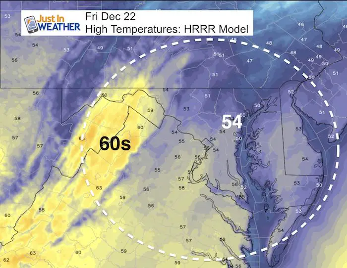
On this first full day of winter, we actually have a warm up. The storm track is passing to our west, keeping us on the warmer side. Traveling might be a problem in northern Pennsylvania and central New York where an icy mix and snow will fall. We will get some rain tonight that will last into Saturday morning. But it looks like a break in the action or at least the rain showers pushed into the northern suburbs during the day. But rain will return late afternoon and evening that may last into the Ravens game in Baltimore. Then we can set out sights on Christmas that still holds hope for snow dreamers.
The high confidence part of this forecast will be the cold air moving in next week and holding through New Years Day. Many days below freezing will ice up the northern Chesapeake Bay and many water ways. It may also bring in another winter storm threat to close out 2017.
Stats For December 22
Normal High: 43ºF
Record High: 71ºF in 2013 (second day in a row)
Normal Low: 27ºF
Record Low: 4ºF in 1989
Snow Record: 5.9″ in 1908
Sunrise: 7:23 AM
Sunset 4:48 PM
*Bay Water Temperature = 43ºF at Thomas Pt. Light House
Snow To Date (at BWI): 3.8″
Keep In Touch All Winter
Click here to sign up for email alerts…. Just in case you don’t get the post on your social media feed
Today: High Temperatures
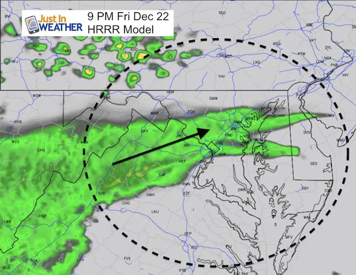
Friday Evening Rain
The leading edge of the approaching storm will spread rain in this evening and it will last overnight.
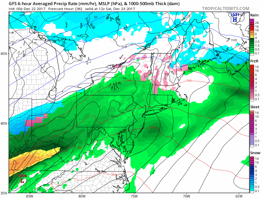
Rain timeline Saturday:
Rain should push north in the morning
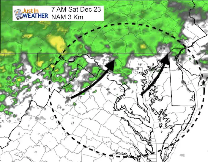
—> slider: NAM 3 Km Model
Rain will return by mid afternoon
[metaslider id=56060]
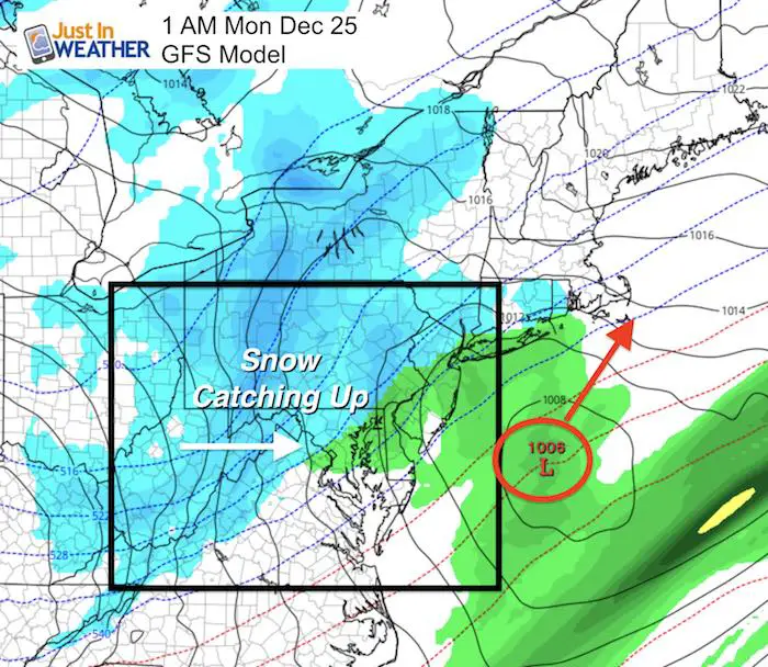
Christmas Snow?
This is where we need to draw back on the recent trend. While the GFS Model is the most aggressive with a few hours of snow early Christmas morning… Remember the three snow events last week. I fact it was the. Saturday and then the following Friday events that were coastal systems that were supposed to be out of reach, but ended up trending west. This was also the combination of the arctic front and an upper level feature arriving from the Great Lakes.
I think there is more adjustment to be had here, and we should see this inch closer to us in the next few model runs.

Last week of 2017
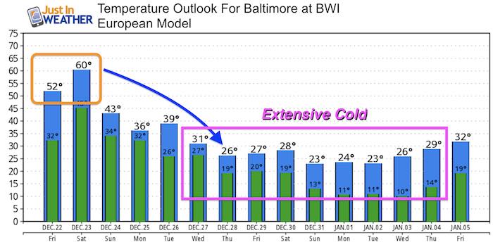
I think we are in good shape. First the chance of snow on Christmas morning, then another storm next weekend. I do not believe this view is a lock and expect more adjustment. However, the cold will hold. The European Model below shows a very cold set up that contradicts the wintry mix shown next weekend on this animation.
Track from this weekend’s rain through the end of 2017 event
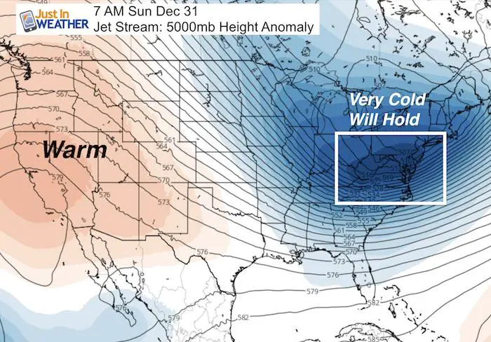
Cold Will Hold
The jet stream appears to lock in the cold air into the end of the year.
Temperature Outlook
As this European Model snows highs in the 20s for a full week, I know this contradicts the wintry mix shown in the GFS Model animation above pro next weekend. That is why long range forecasting is not a lock. I am on board with the cold holding.
Please share your thoughts, best weather pics/video, or just keep in touch via social media
-
Facebook: Justin Berk, Meteorologist
-
Twitter: @JustinWeather
-
Instagram: justinweather
FITF Gear

Snowstix- We Need You To Measure Snow Too
We are giving 10% of each sale to programs that benefit pediatric oncology patients.

 Get the award winning Kid Weather App I made with my oldest son and support our love for science, weather, and technology. Our 3 year anniversary of the release and our contribution to STEM education is this November. It has been downloaded in 60 countries, and works in both temperature scales. With your support we can expand on the fun introduction to science and real weather.
Keep In Touch All Winter
Click here to sign up for email alerts…. Just in case you don’t get the post on your social media feed
Also See:
My Winter Outlook 2017-2018 for more snow
La Nina Formed: What it could mean to our winter
NOAA Winter Outlook: Not The Best But Not The Worst For Snow
Two Farmers Almanacs Winter 2018 Outlooks
Winter Weather Folkore: Suggestions from Animals and Crops
First Frost and Freeze Dates For Maryland (southern PA and northern VA)
My Preliminary Winter Outlook Notes
Low Snow Winters In Baltimore: To Repeat Or Not Repeat
NOAA Ranks Blizzard 2016 4th Worst Snowstorm On Record
Blizzard 2016 Record Top Snowstorm: Area Totals
Extreme Weather of 2015 balanced out on both ends