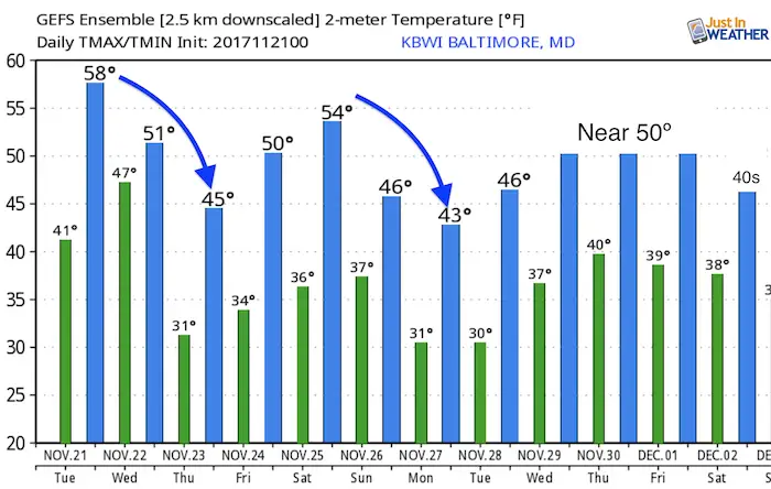
Tuesday November 21
You want to know something interesting? 117 years ago on this date, Baltimore hit a record high of 79ºF. Yeah, that’s not going to happen this year. We have flipped the switch to normalcy and will be trending coder for the foreseeable future. While we will warm a little this afternoon, clouds moving in will signal the next storm that is going to bring some of us rain tonight. Some, not all. The trend we all get will be colder winds into Thanksgiving and then another shot over the weekend that might bring some of that Lake Effect Snow over the mountains with flurries on Sunday. Here’s the quick run-down…
Stats For November 21
Normal High: 54ºF
Record High: 79ºF in 1900
Normal Low: 35ºF
Record Low: 16ºF in 1951
Sunrise: 6:57 AM
Sunset 4:48 PM
Keep In Touch All Winter: Sign up for email updates on new posts
Since you may miss some posts via social media, click here for email alerts as a way to make sure you don’t miss any. *You may have to refresh that page once for your browser to clear out the images.
Mild Afternoon
A sunny morning will give way to increasing clouds, but we will remain dry during the day.
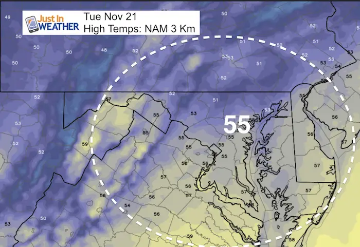
Rain Overnight…. East
A coastal system will bring rain around the Chesapeake Bay and Eastern Shore. But it develops around midnight and should be ending during Wednesday morning. On the flip side, snow showers will move into western Maryland. Only a dusting if anything expected there.
––> slider: Radar Simulation
[metaslider id=54881]
In case you missed it…. See My Winter Outlook 2017-2018 for more snow
Thanksgiving and Friday will be dry but colder…
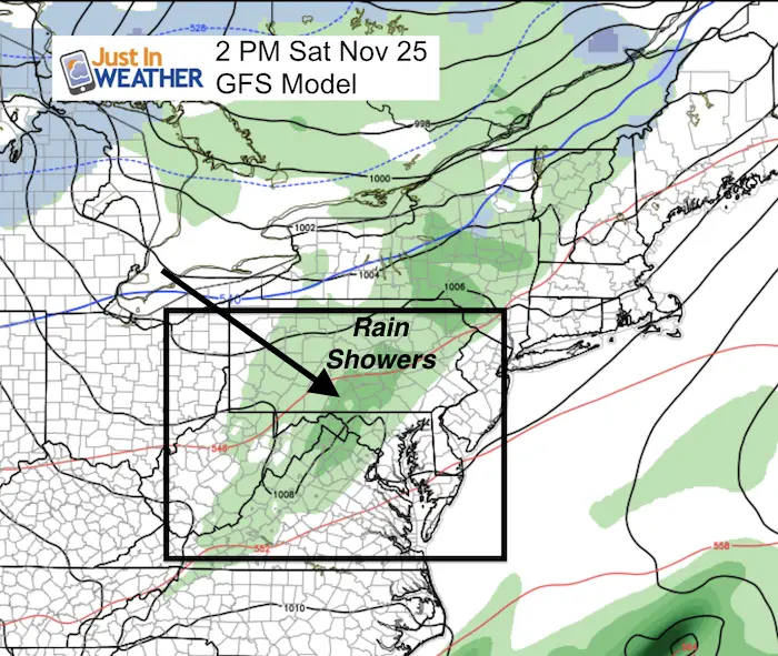
Weekend Outlook
Saturday (Rain) Showers:
The next system will bring in rain showers Saturday afternoon and evening.
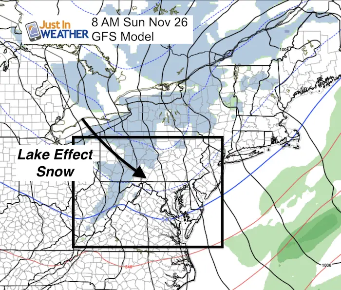
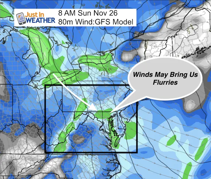
Sunday Morning Flurries?
The colder air and wind direction on Sunday morning supports some Lake Effect Snow crossing the mountains. Much like this past Sunday night, we could get in on the action early this Sunday morning. Just a few flakes and no stickage expected.
Snowstix- Ready For Delivery
We are giving 10% of each sale to programs that benefit pediatric oncology patients.
Jet Stream Trending Colder Than Normal Into December
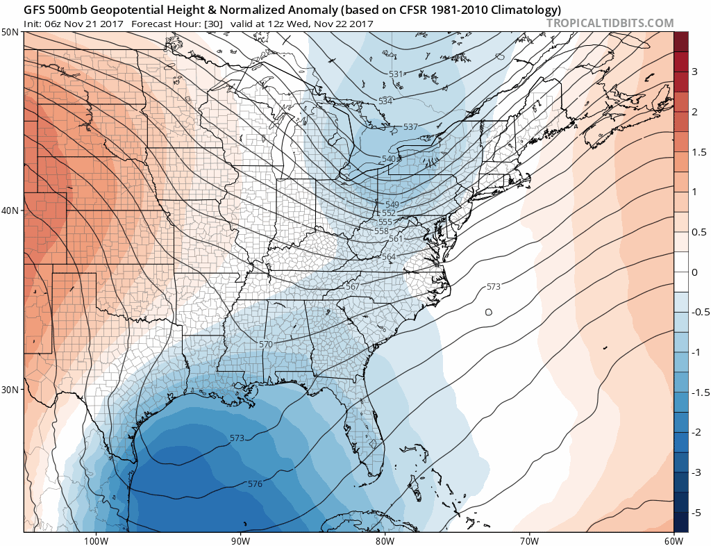
Temperature Outlook
Faith in the Flakes Online Store Is Back Open By Popular Demand
PJ bottoms still inside out- They have to be to help bring on the snow.

 Get the award winning Kid Weather App I made with my oldest son and support our love for science, weather, and technology. Our 3 year anniversary of the release and our contribution to STEM education is this November. It has been downloaded in 60 countries, and works in both temperature scales. With your support we can expand on the fun introduction to science and real weather.
Please share your thoughts, best weather pics/video, or just keep in touch via social media
-
Facebook: Justin Berk, Meteorologist
-
Twitter: @JustinWeather
-
Instagram: justinweather
Also See:
My Winter Outlook 2017-2018 for more snow
La Nina Formed: What it could mean to our winter
NOAA Winter Outlook: Not The Best But Not The Worst For Snow
Two Farmers Almanacs Winter 2018 Outlooks
Winter Weather Folkore: Suggestions from Animals and Crops
First Frost and Freeze Dates For Maryland (southern PA and northern VA)
My Preliminary Winter Outlook Notes
Low Snow Winters In Baltimore: To Repeat Or Not Repeat
NOAA Ranks Blizzard 2016 4th Worst Snowstorm On Record
Blizzard 2016 Record Top Snowstorm: Area Totals
Extreme Weather of 2015 balanced out on both ends
Early Christmas Shopping? FITF Gear Is Here
Limited Edition 11:11 FITF Clock
Make That Wish For Snow