Tuesday October 17
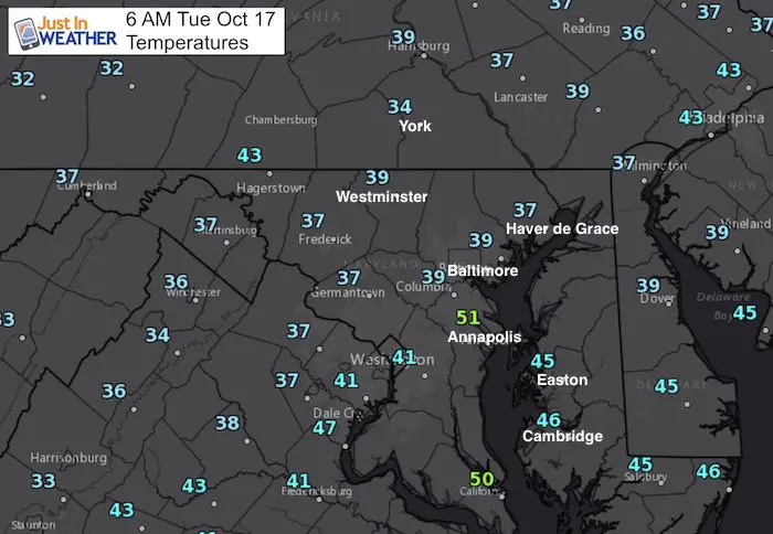
The first frost of the season is with us right now. If you live in the colder region west and north of Baltimore, you might want to give yourself a few minutes to warm the car and scrape the windshield. The 39ºF reading is the coldest Baltimore has hit since last May 8th. The reality check will remain with us all day, so sunrise will melt the frost, but afternoon temperatures will be below average. Many will stay in the upper 50s and my 6th grader is thrilled to wear his first pair of jeans to school. I don’t know what finally convinced him that there are other items besides shorts, but this dad is going with it.
We will be back into the 70s this weekend. If you are part of the Baltimore running festival, the weather looks perfect in the morning and warm to celebrate after the race. Next week however with bring a new cold air mass that may open up the Great Lakes to bring the first snow flakes to the mountains of western Maryland.
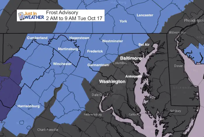
Frost Advisory Through 9 AM
Also see the map for our Average First Frost/Freeze Dates
Stats For October 17
Normal High: 66ºF
Record High: 90ºF in 1938
Normal Low: 45ºF
Record Low: 33ºF in 1982
Sunrise: 7:19 AM
Sunset 6:25 PM
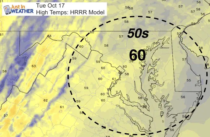
High Temps Today
Jumping Ahead To Next Week
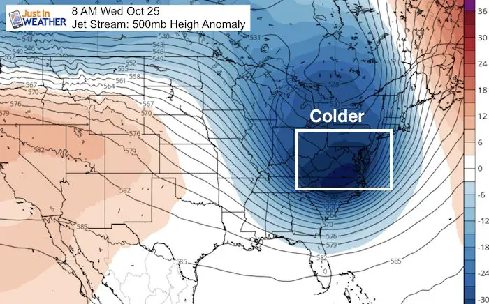
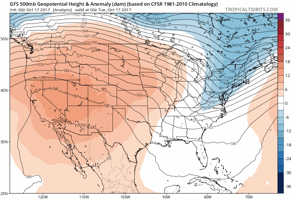
This Jet Stream view shows heights of the 500mb level that fluctuates with temperature around 18,000 Ft. Red= warmer than normal; Blue = colder than normal.
FITF ❄️
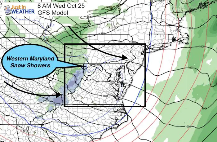
The long range outlook shows Lake Enhanced showers next Wednesday morning. The blue indicates snow in Garrett County, the first flakes of the season in western Maryland are possible.
Trust in this Bust- Limited Edition Shirt
This fundraiser is for breast cancer research at BCRF- the highest rated cancer research charity. It is only available for another week. This soft Bella T-Shirt is to promote the strength of the ‘good bust’ and the heart that beats strong beneath it. Proceeds will be donated in honor of my mother Linda Berk, a 3-time breast cancer survivor. Click on the shirt image to join us.
Jet Stream Animation:
Notice the chill retreating this weekend, but building back next week.
.
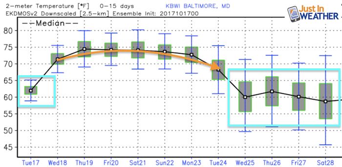
Temperature Outlook
After another warm stretch in the 70s, the cold air mass next week will be colder than what we have now. While this model below shows highs near 60ºF, IU think 50s will be the rule when it arrives. That also means more widespread frost and maybe our first freeze by the end of next week.
Sign up for email updates on new posts
Since you may miss some posts via social media, click here for email alerts as a way to make sure you don’t miss any. *You may have to refresh that page once for your browser to clear out the images.
 Get the award winning Kid Weather App I made with my oldest son and support our love for science, weather, and technology. Our 3 year anniversary of the release and our contribution to STEM education is this November. It has been downloaded in 60 countries, and works in both temperature scales. With your support we can expand on the fun introduction to science and real weather.
Please share your thoughts, best weather pics/video, or just keep in touch via social media
-
Facebook: Justin Berk, Meteorologist
-
Twitter: @JustinWeather
-
Instagram: justinweather