 Friday October 13 2017
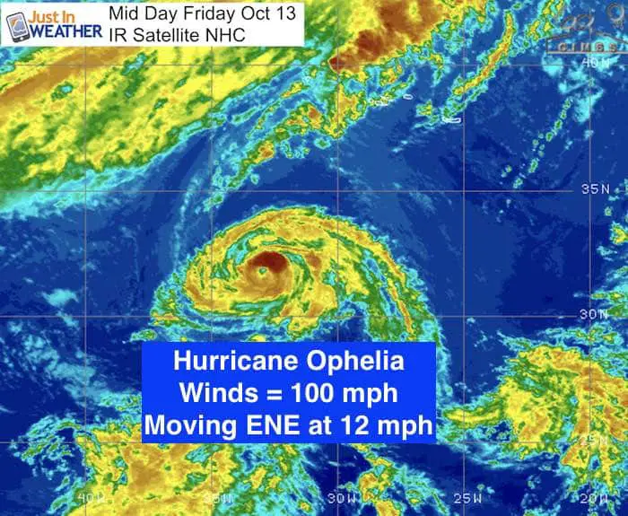
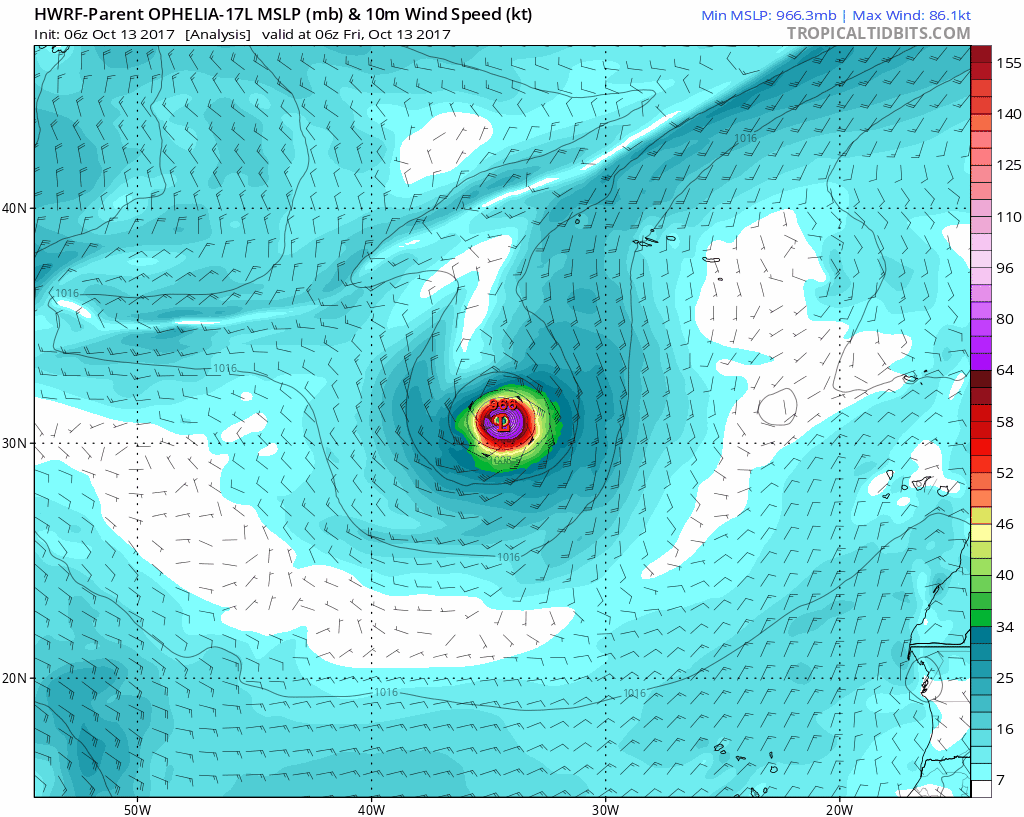
Hurricane Ophelia remains a Category 2 storm with 100 mph winds. It has broken away from the nearly stationary status and is moving to the east northeast at 12 mph. The rare thing here is that the waters in this part of the Atlantic tend to get quite cool along the path to the north. But a strong cold front will be grabbing Ophelia and increasing the forward speed so that it will hold on the the strength of a hurricane when it reaches Ireland on Monday October 16.
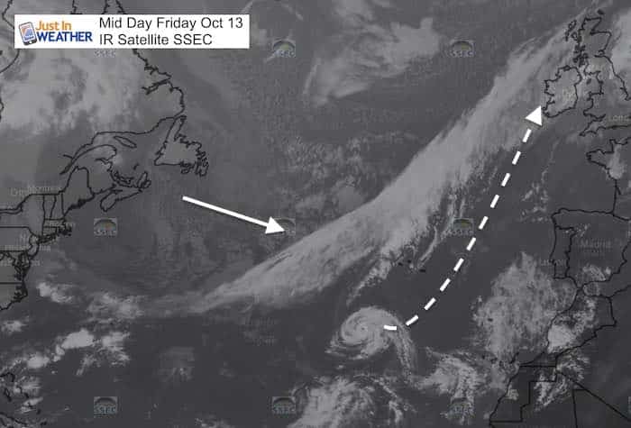
Not the wrong direction
While it may appear that this is moving the wrong way (to the east), this storm is not at a tropical latitude. This is along the same latitude as South Carolina, so the westerlies are quite common. That is why it was nearly stalled before moving this way… and the push ahead of that front took over.
National Hurricane Center Stats
SUMMARY OF 1100 AM AST…1500 UTC…INFORMATION
———————————————–
LOCATION…31.8N 32.9W
ABOUT 545 MI…875 KM SW OF THE AZORES
MAXIMUM SUSTAINED WINDS…100 MPH
PRESENT MOVEMENT…ENE OR 60 DEGREES AT 12 MPH.
MINIMUM CENTRAL PRESSURE…971 MB…28.68 INCHES
What Makes Hurricane Ophelia Such A Big Deal:
- 10th hurricane in a row! Each of the last 10 named storms all reached hurricane intensity. The only other documented times were in 1878, 1886, and 1893 in the pre-satellite era)
- 100 mph winds makes this the strongest October hurricane this far east in the Atlantic. Usually the water is just too cool to support this.
- 1961 was the last time a hurricane hit Europe
- 1987 Great Storm: That was a post tropical storm that hit France and England on Oct 16-17, which would be the same dates Ophelia hits. The highest measured gust of 135 mph was recorded at Pointe Du Roc, Granville, France and the highest gust in the U.K. of 120 mph was recorded at Shoreham-by-Sea.
Great Britain Impact
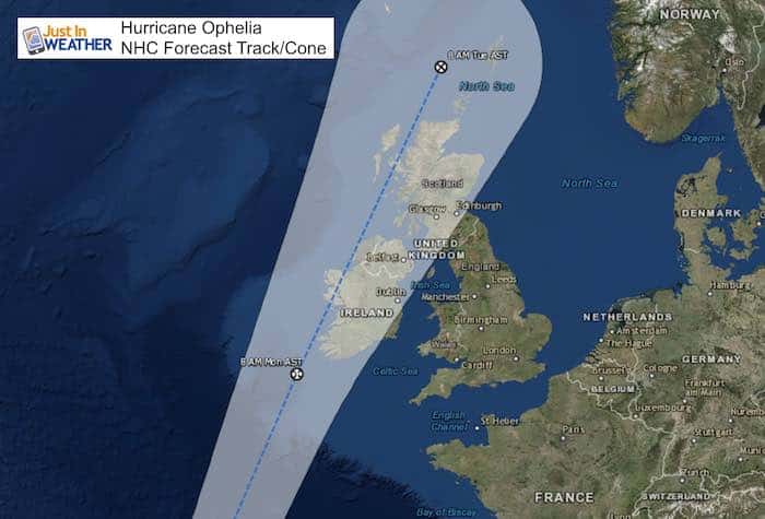
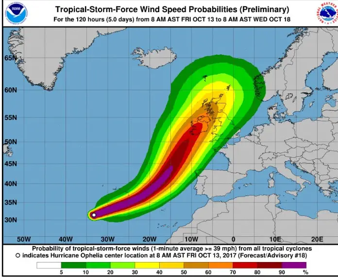
It is important to note that the strongest side of the storm will be on the east or right of forward motion. Hurricane force winds extend 25 miles from the center. Tropical storm force winds reach 90 miles away. This is a small storm, but it still puts Dublin on the stronger side. While London will be farther away from the center, the northern British Islands will feel the impact. It is likely winds will average 50 to 80 mph across Ireland and northern Great Britain. Winds across southern England around London might have gusts over 40 mph. The rainfall may be similar to the Azores forecast of 1 to 3 inches due to the fast forward speed.
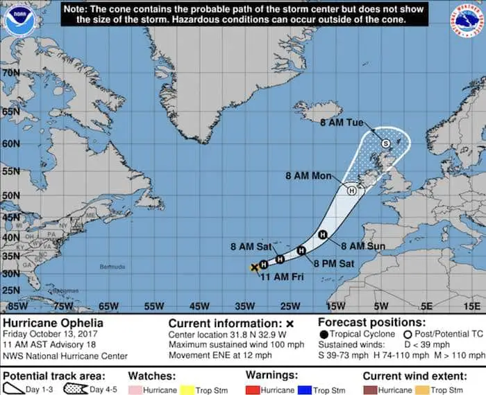
Here is the National Hurricane Center forecast cone showing the expected path across the islands on Monday afternoon and evening.
Forecast Track Animation
NHC Maps
Sign up for email updates on new posts
Since you may miss some posts via social media, click here for email alerts as a way to make sure you don’t miss any. *You may have to refresh that page once for your browser to clear out the images.
Trust in this Bust- Limited Edition Shirt
This is not a forecast, but a fundraiser for breast cancer research at BCRF- the highest rated cancer research charity. This soft Bella T-Shirt is to promote the strength of the ‘good bust’ and the heart that beats strong beneath it. Proceeds will be donated in honor of my mother Linda Berk, a 3-time breast cancer survivor. Click on the shirt image to join us.

Please share your thoughts, best weather pics/video, or just keep in touch via social media
-
Facebook: Justin Berk, Meteorologist
-
Twitter: @JustinWeather
-
Instagram: justinweather