Thursday October 5
Tropical Storm Nate has been officially named by the National Hurricane Center this morning. The winds are only 40 mph and it is moving to the north. It may cut across Mexico’s Yucatan Peninsula including Cancun en rough to the Gulf of Mexico and the US coast. The timing and track places the potential to become a minimal hurricane before landfall on Sunday. Here are the latest stats and forecasts. Note that our region is on the verge of drought conditions and much needed rain will spread ahead of the storm itself, lasting a few days next week.
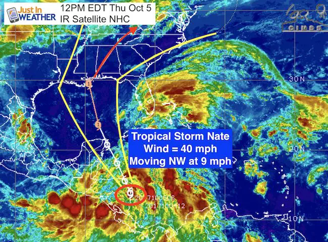
LOCATION…14.3N 83.7W
ABOUT 30 MI…45 KM NW OF PUERTO CABEZAS NICARAGUA
ABOUT 65 MI…105 KM S OF PUERTO LEMPIRA HONDURAS
MAXIMUM SUSTAINED WINDS…40 MPH…65 KM/H
PRESENT MOVEMENT…NW OR 325 DEGREES AT 9 MPH…15 KM/H
MINIMUM CENTRAL PRESSURE…999 MB…29.50 INCHES
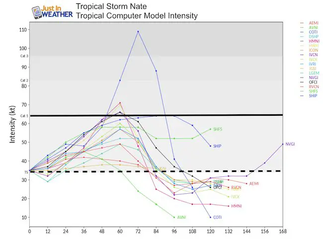
Forecast Intensity
Some of the variation depends on how close the center gets to land or if it does cross inland by Cancun. But once in the Gulf of Mexico this weekend, it is expected to have a chance to become a minimal Category 1 hurricane before landfall on the US coastline.
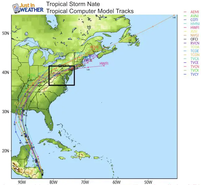
Model Tracks
The trend has shifted about 100 miles west. Does this look familiar? Last night I showed the European Model as the center of the cone forecast in western Florida. Now this shows a center of the cone near New Orleans, which was closer to the GFS forecast on the west side of last night’s cone. The National Hurricane Center Forecast is below to compare. While there has been a shift to the west, I would caution to see if we end up with the same result as prior tropical storms…. The track will wobble and may adjust back east a little (Irma started as a Miami hit, then Key West, but tracked into the central Keys).
National Hurricane Center Forecast
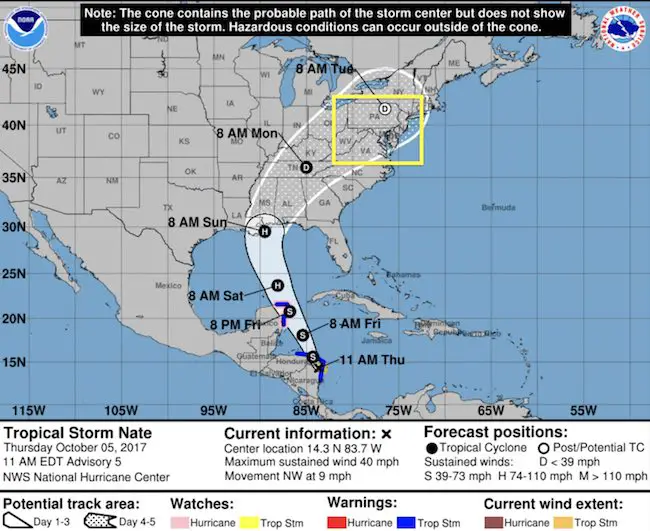
Tracking Inland
Tropical Storm Wind Arrival- The storm should weaken inland, and likely down to a depression or diminishing when reaching the Mid Atlantic next week.

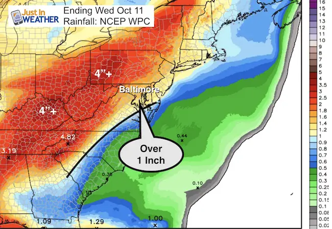
Rainfall Potential
This is the part our region needs with the lack of rain in the past 3 to 4 weeks.
The projection through Wednesday shows over 1 inch for much of Maryland, Pennsylvania, and Virginia west of I-95.
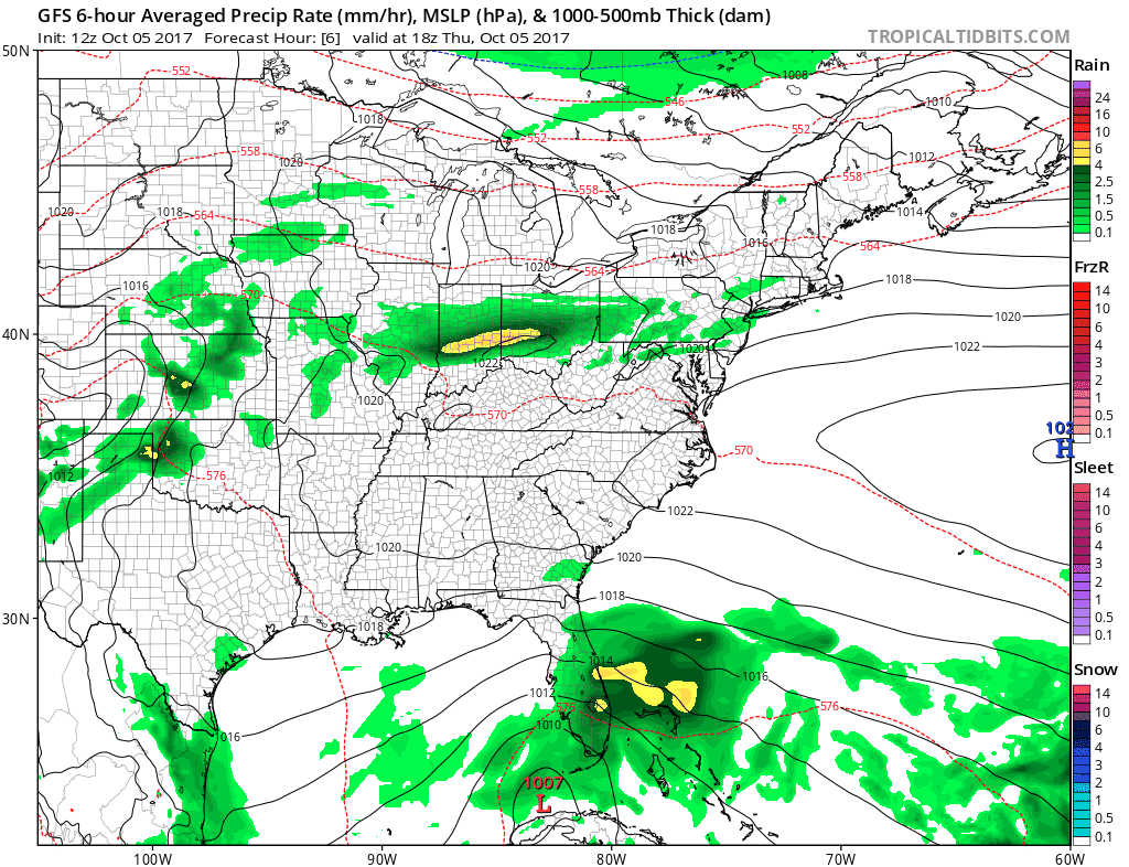
Forecast Animation
This is the GFS Model… Only one version, but it is the model that had the track last night that the NHC is locking on to today. This shows the Low Pressure passing directly over central Maryland next Monday evening.
Please share your thoughts, best weather pics/video, or just keep in touch via social media
-
Facebook: Justin Berk, Meteorologist
-
Twitter: @JustinWeather
-
Instagram: justinweather
 Get the award winning Kid Weather App I made with my oldest son and support our love for science, weather, and technology. Our 3 year anniversary of the release and our contribution to STEM education is this November. It has been downloaded in 60 countries, and works in both temperature scales. With your support we can expand on the fun introduction to science and real weather.