 Thursday September 7
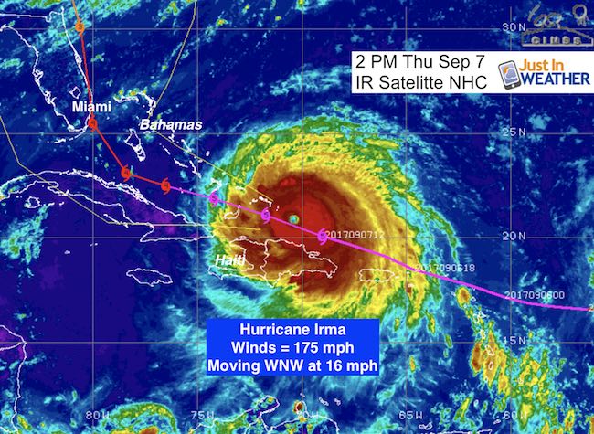
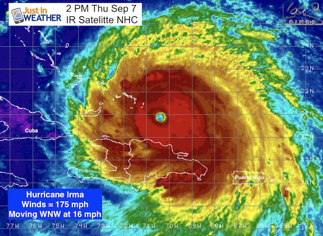
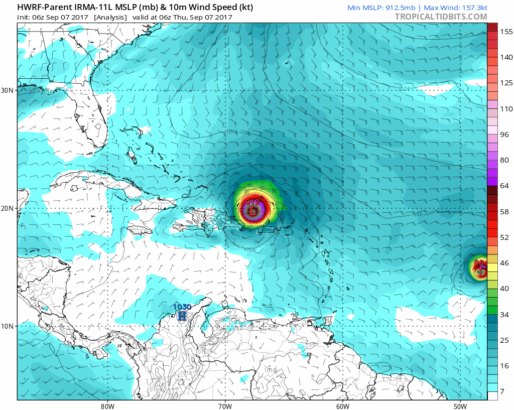
Hurricane Irma is taking a direct hit on the Turks and Caicos Islands today with winds now at 175 mph. The target towards the United States mainland this weekend will hit a highly populated area. I need to state that my parents have property in south Florida so I feel the anxiety first hand with the precise track of this storm and the resulting impact. I have friends and other family in the path and have recommended my friend and fellow Cornell graduate Meteorologist Jeff Beradelli from WPEC, CBS 12 to follow. A Hurricane Watch has been issued for many counties in south Florida and there will be more as the time frame shrinks under 48 hours until impact. My purpose here is to explain how the storm is broken down and how the structure is NOT the same on all sides. Also, the track to the north could have impacts in Maryland even though the storm itself should pass well inland to our south.
Threats to south Florida
- Rain: 5 to 20 inches
- Storm Surge: 5 to 10 feet
- Winds: Over 140 mph
- Tornados at landfall
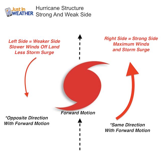
Hurricane Structure Breakdown
It is important to look at a tropical system with forward motion.
- The Right Side is the stronger side as the outer-clockwise wind flow moves with the forward speed. Plus it comes off of the water. So the storm surge will be highest here.
- The Left Side is the weaker side as the winds are moving opposite the forward speed. Also, the wind off of the land. The storm surge drops off dramatically farther to the left
- The eye wall itself is where the strongest winds are located. The winds decrease farther away from the center. Irma is described as having hurricane force winds 60 miles from the center. That means the eye wall has 175 mph winds, but 60 miles away the winds are 75 mph. The tropical storm force winds (over 40 mph) extend 185 miles away from the center in all directions.
This will be devastating!
- As the storm approaches land, it will be impacted by dry air from the land.
- Tornados will spin up inside the hurricane.
- Flooding will come from rain falling and ocean water pushed inland.
Thursday Afternoon Irma Breakdown
- Hurricane force winds extend 60 miles from the center. The 175 mph winds are at the eye wall, then slow to 75 mph winds 60 miles away
- Tropical storm force winds (over 40 mph) extend 185 miles away from the center in all directions. That is 370 miles across.
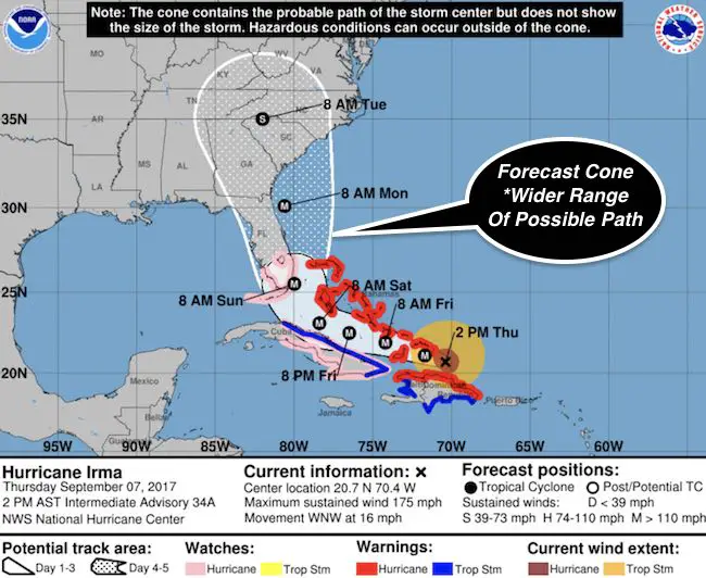
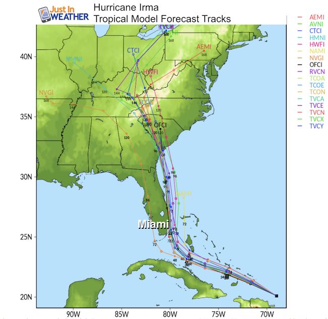
National Hurricane Center Track
The exact track is critical. A shift of 50 miles to the east could save Miami to West Palm Beach keeping the strongest part and eye wall offshore. Still horrible for The Bahamas. If this track is correct and the eye wall hits Miami OR if it is just inland, this will be more catastrophic than any other weather event in our nation’s history. Miami has the 3rd most sky scrapers in the US. The strongest winds will be above the ground and without question will have trouble with winds over 140 mph as forecast below.
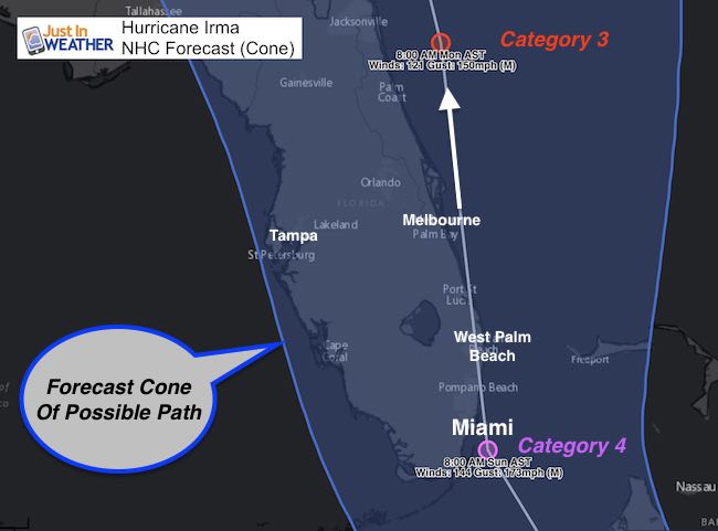
- Please note the Cone is the potential variation of path. The middle is not the promise!
- This track shows a path over Miami but that is NOT A PROMISE!
- This is an average or blend of computer models and the prior forecasts. This is so there is no abrupt jump and waiting for more consistency in projections.
- Click here to see: Irma video of radar and satellite as it passed Puerto Rico
Hurricane Watches
Mandatory evacuations are in place along the coast and expect more to be enforced
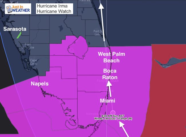
A Storm Surge Watch is in effect for…
* Jupiter Inlet southward around the Florida peninsula to Bonita
Beach
* Florida Keys
A Hurricane Watch is in effect for…
* Jupiter Inlet southward around the Florida peninsula to Bonita
Beach
* Florida Keys
* Lake Okeechobee
* Florida Bay
* Cuba from Matanzas province eastward to Guantanamo provi
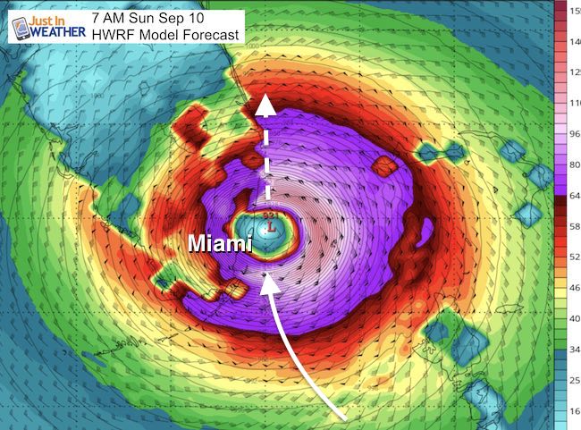
Forecast Map:
This is the HWRF Model snapshot showing the eye wall Sunday morning over Miami. Remember the wiggle room for potential error at least of 20 to 50 miles east or west of this track. See the animation below. Farther east would be best. This track or west/inland will be the worst!
Forecast Animation
We know the storm will turn, but when?
Should the eye miss Miami, the results for Georgia and South Carolina will be worse since the storm would hold together better. The landfall here shows the widest cone and no way to know where until we see the turn and path by Miami.
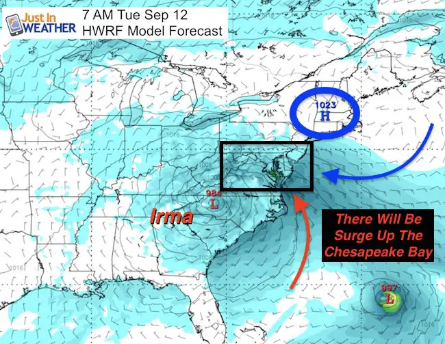
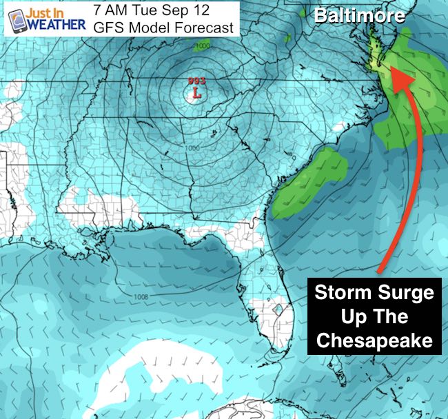
Farther North: Chesapeake Bay Gets Some Surge
Here in the Mid Atlantic the impacts will be secondary. I see the potential for an indirect storm surge up The Chesapeake Bay. The storm should go inland well to our south. However the wave memory of a former 185 mph wind storm PLUS the High Pressure off of New England will help to pile the water onshore, and eventually up the Bay. Water levels will rise Monday, but the highest water will be after a few high tide cycles can not drain… So the highest water will be Tuesday and Wednesday. It is too early to say how high the water will reach. At this time I DO NOT see a repeat of Isabel’s surge, but this is worth paying attention to closely. We should have that impact better known by Sunday.
Note: If Irma goes inland west of Miami, then the chance for a surge into the Chesapeake Bay diminishes
GFS Model turns Irma farther west.. Inland
Forecast Models
The bulk of model show Irma moving inland across South Carolina and into the mountains. There will be flooding there and the storm will be torn apart quickly. This is NOT Harvey and will not stall.
Keep on Trekking
Continue to be part of our Maryland Trek and Support Cool Kids Campaign. This was our best event yet and we want the message to carry throughout the year.
Proceeds go to programs that help children and their families ensuring cancer treatment.

Please share your thoughts, best weather pics/video, or just keep in touch via social media
-
Facebook: Justin Berk, Meteorologist
-
Twitter: @JustinWeather
-
Instagram: justinweather
 Get the award winning Kid Weather App I made with my oldest son and support our love for science, weather, and technology. Our 3 year anniversary of the release and our contribution to STEM education is this November. It has been downloaded in 60 countries, and works in both temperature scales. With your support we can expand on the fun introduction to science and real weather.