 Monday July 31
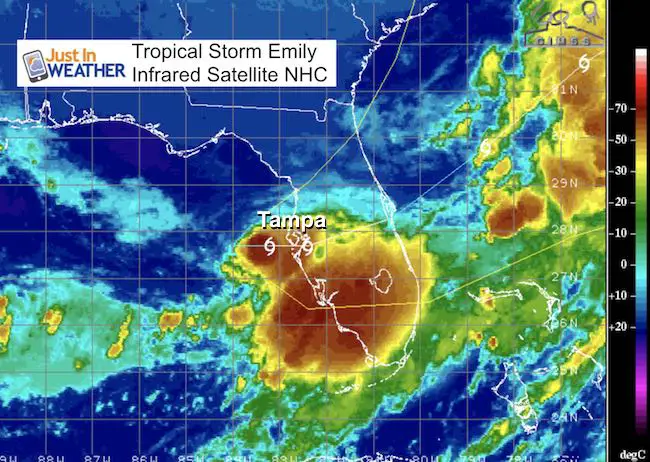
This is a bit of a surprise this morning. Tropical Storm Emily was official named this morning in the Gulf of Mexico. In fact it was identified as a an area of interest overnight and then named a tropical storm at 8 AM this morning. Top winds already at 45 mph. It was located 45 miles to the west southwest of Tampa and expected to make landfall in just a few hours early this afternoon. The rapid intensification could mean a better chance for tornados at landfall, but a good thing it hits land before growing much stronger.
All of the energy is located near and south of the center, putting heavy rainfall across central and southern Florida. Overall between 2 and 4 inches of rain is expected, which is not much more than a summer thunderstorm can produce in the tropical environment. See the morning report and forecast track below.
Live Radar Loop

National Hurricane Center Morning Report
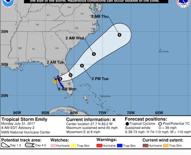
…DEPRESSION BECOMES A TROPICAL STORM WEST OF TAMPA BAY…
…TROPICAL STORM WARNING ISSUED FOR WEST-CENTRAL FLORIDA…
SUMMARY OF 800 AM EDT…1200 UTC…INFORMATION
———————————————-
LOCATION…27.7N 83.2W
ABOUT 45 MI…75 KM WSW OF TAMPA FLORIDA
ABOUT 50 MI…80 KM WNW OF SARASOTA FLORIDA
MAXIMUM SUSTAINED WINDS…45 MPH…75 KM/H
PRESENT MOVEMENT…E OR 95 DEGREES AT 8 MPH…13 KM/H
MINIMUM CENTRAL PRESSURE…1006 MB…29.71 INCHES
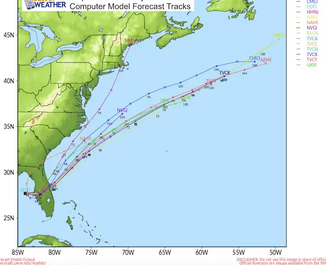
Forecast Track
This storm will cross Florida and then head out into the Atlantic. The momentum and upper level winds should carry it off of the coast, but could make for strong waves and rip currents across the North Carolina Outer Banks.
Please share your thoughts, best weather pics/video, or just keep in touch via social media
-
Facebook: Justin Berk, Meteorologist
-
Twitter: @JustinWeather
-
Instagram: justinweather
 Get the award winning Kid Weather App I made with my oldest son and support our love for science, weather, and technology. Our 3 year anniversary of the release and our contribution to STEM education is this November. It has been downloaded in 60 countries, and works in both temperature scales. With your support we can expand on the fun introduction to science and real weather.
Maryland Trek 2017
Donations now being accepted. Please select “Cool Kids Campaign” in the options to add to our entire team’s total.
Milestones this year:
- I will do my 1000th mile on Day 1 in Garrett County
- We aim to reach $100,000 for Cool Kids Campaign for the entire event.

Kent Island Tornado
Doppler Radar Loop: Likely Tornado On Kent Island July 24
Tornado Damage Photos On Kent Island: July 24 2017
Waterspout Video and Photos July 15 2017
Waterspouts photos August 21 2016
Faith in the Flakes
The store is closing for the season. Next week we wil be shifting back to spring mode. This will include a severe weather STEM assembly program.
-
Sign up for email updates on new posts
Since you may miss some posts via social media, click here for email alerts as a way to make sure you don’t miss any. *You may have to refresh that page once for your browser to clear out the images.
Also See: