Tuesday July 11,
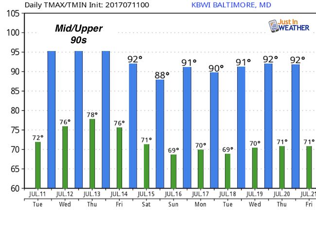
Today is just the beginning of our 90 degree stretch. The higher heat will eventually be followed by even more humidity, making for a true heat wave. The worst of the heat should be Thursday, with the peak of the storms building Thursday evening and into Friday. The best bet is that we improve by the weekend. But first we must get through today.
We have a slight chance of storms with severe potential of high winds and hail. The heat will fuel that. Here is look at the radar simulation. I also want to point out that our local Doppler Radar at Sterling, VA labeled KLWX is down for scheduled maintenance. So some of your phone apps may not pick up on the regional periphery of radars.. and it will be a little more challenging to track.
—> slider
[metaslider id=49645]
Temperature Outlook
 Get the award winning Kid Weather App I made with my oldest son and support our love for science, weather, and technology. Our 3 year anniversary of the release and our contribution to STEM education is this November. It has been downloaded in 60 countries, and works in both temperature scales. With your support we can expand on the fun introduction to science and real weather.
Get $1000 Off LASIK
Plus enter to win free sunglasses

Maryland Trek 2017
Be part of my 4th annual hike and bike across Maryland this August. See my trek page and sign up for information to do one day, the whole week, or even sponsor this great event.
Milestones this year:
- I will do my 1000th mile
- We aim to reach $100,000 for Cool Kids Campaign

Please share your thoughts, best weather pics/video, or just keep in touch via social media
-
Facebook: Justin Berk, Meteorologist
-
Twitter: @JustinWeather
-
Instagram: justinweather
Faith in the Flakes
The store is closing for the season. Next week we wil be shifting back to spring mode. This will include a severe weather STEM assembly program.
-
Sign up for email updates on new posts
Since you may miss some posts via social media, click here for email alerts as a way to make sure you don’t miss any. *You may have to refresh that page once for your browser to clear out the images.
Also See: