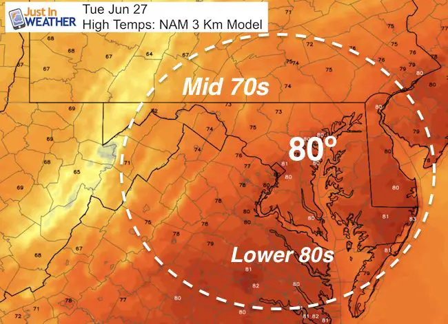
Tuesday June 27
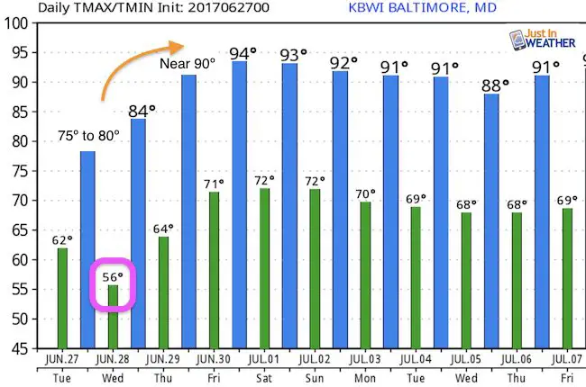
A few rain showers and more clouds today will keep temperatures well below normal. Highs will range from the mid 70s to near 80ºF, which is hardly pool weather. The core of the cool air in the atmosphere is overhead and may trigger some isolated thundershowers this afternoon. By Wednesday morning many will be in the 50s, and then a gradual bounce back up. So hang on, July will start with a heat wave.
As for today’s showers, the threat is 20%, which means most will stay dry. Here’s a look at the scattering of activity today
Simulated Radar —-> slider
[metaslider id=49284]
High Temps Today
Outlook
The core of the cool air is over us today, but watch the building ridge along the southeast US that will surge warmer air up the coast this weekend.
[metaslider id=49308]
Temperatures
Wednesday morning will have widespread 50s… Then we will have widespread 90s over the weekend
 Get the award winning Kid Weather App I made with my oldest son and support our love for science, weather, and technology. Our 3 year anniversary of the release and our contribution to STEM education is this November. It has been downloaded in 60 countries, and works in both temperature scales. With your support we can expand on the fun introduction to science and real weather.
Get $1000 Off LASIK
Plus enter to win free sunglasses

Maryland Trek 2017
Be part of my 4th annual hike and bike across Maryland this August. See my trek page and sign up for information to do one day, the whole week, or even sponsor this great event.
Milestones this year:
- I will do my 1000th mile
- We aim to reach $100,000 for Cool Kids Campaign

Please share your thoughts, best weather pics/video, or just keep in touch via social media
-
Facebook: Justin Berk, Meteorologist
-
Twitter: @JustinWeather
-
Instagram: justinweather
Faith in the Flakes
The store is closing for the season. Next week we wil be shifting back to spring mode. This will include a severe weather STEM assembly program.
-
Sign up for email updates on new posts
Since you may miss some posts via social media, click here for email alerts as a way to make sure you don’t miss any. *You may have to refresh that page once for your browser to clear out the images.
Also See: