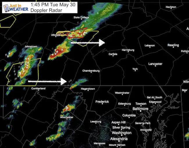
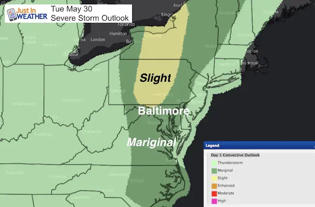
 Tuesday May 30- 1:45 PM
The slight risk of severe storms for our region plus the watches and warnings that have already fired up in Pennsylvania are enough to prompt the need to babysit the radar. As of my post time, there was a Watch Box for PA and isolated warnings, included a Tornado Warning just south of State College set to expire at 2 PM. But there was a history of large hail with that cell.
A line of storms farther south was breaking up nee Hancock, MD and along I-81 from Martinsburg to Winchester and Front Royal. This is expected to not be a factor for long as our cool, damp marine layer is battering this down. But the front with more force should arrive this evening.
Below is the radar simulation showing that our region should start to watch for showers and storms by 5 and 6 PM and spread through central Maryland and the Eastern shore this evening. This is NOT perfect, but the best gauge to track the activity for the next few hours ahead. Also allowing us parents and coaches to plan for potential rain delays in today’s games.
—> slider HRRR Model
[metaslider id=48351]

 Get the award winning Kid Weather App I made with my oldest son and support our love for science, weather, and technology. Our 3 year anniversary of the release and our contribution to STEM education is this November. It has been downloaded in 60 countries, and works in both temperature scales. With your support we can expand on the fun introduction to science and real weather.
Get $1000 Off LASIK
Plus enter to win free sunglasses
Maryland Trek 2017
Be part of my 4th annual hike and bike across Maryland this August. See my trek page and sign up for information to do one day, the whole week, or even sponsor this great event.
Milestones this year:
- I will do my 1000th mile
- We aim to reach $100,000 for Cool Kids Campaign
Please share your thoughts, best weather pics/video, or just keep in touch via social media
-
Facebook: Justin Berk, Meteorologist
-
Twitter: @JustinWeather
-
Instagram: justinweather
Faith in the Flakes
The store is closing for the season. Next week we wil be shifting back to spring mode. This will include a severe weather STEM assembly program.
-
Sign up for email updates on new posts
Since you may miss some posts via social media, click here for email alerts as a way to make sure you don’t miss any. *You may have to refresh that page once for your browser to clear out the images.
Also See:


