Thursday April 6 – Severe weather was advertised all week as we tracked the southern storm heading our way. Despite the cooler air holding many in the 50s, the weather put on quite a show and possibly produced a tornado. The photos many shared with me ranged from cool clouds, storm damage, and even a spectacular rainbow. Here is a look at the storm scenes across our region:
Was there a tornado?
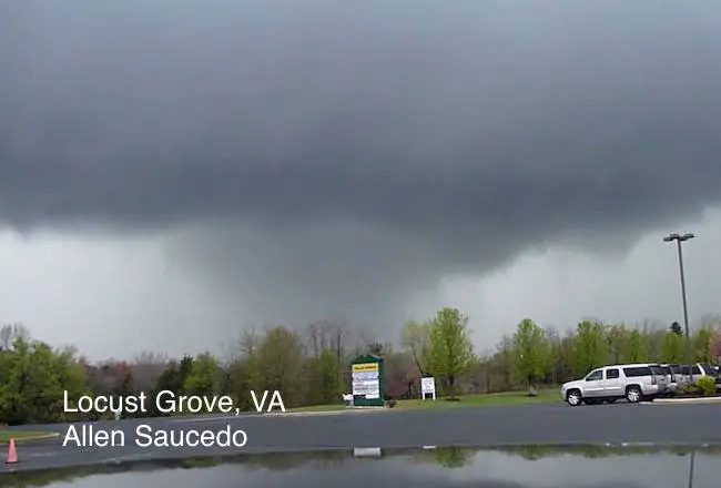
There was a tornado warning in northern Virginia, which could be associated with this. But it was not the only report of the potential. This photo is either an intense rain shaft or a rain wrapped funnel clouds. This was spotted by Allen Saucedo in Locust Grove, VA. He said there was lost of tree damage in this area after passing by.
Harford County Maryland?
Melanie Copper reported rotation and debris in Abingdon, MD. I am looking to corroborate confirm this report
Shelf Cloud On The Chesapeake Bay
Thanks to Kirk Groves


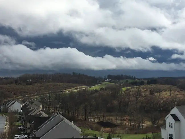
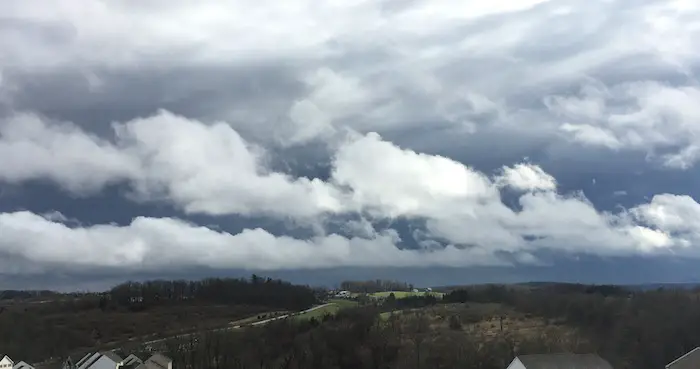
Cool Clouds
I saw these long clouds stretched across the entire sky between heavy rain bands as the center of Low Pressure passed overhead mid afternoon.
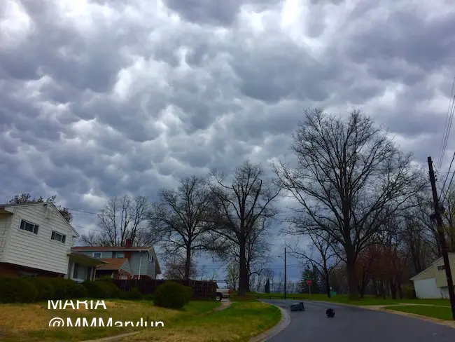
Mammatus Clouds
These pouches are from multiple downdrafts that are often a sign of a severe storm that is past its peak and weakening. Maria captured these (and a rainbow) in Rockville, MD
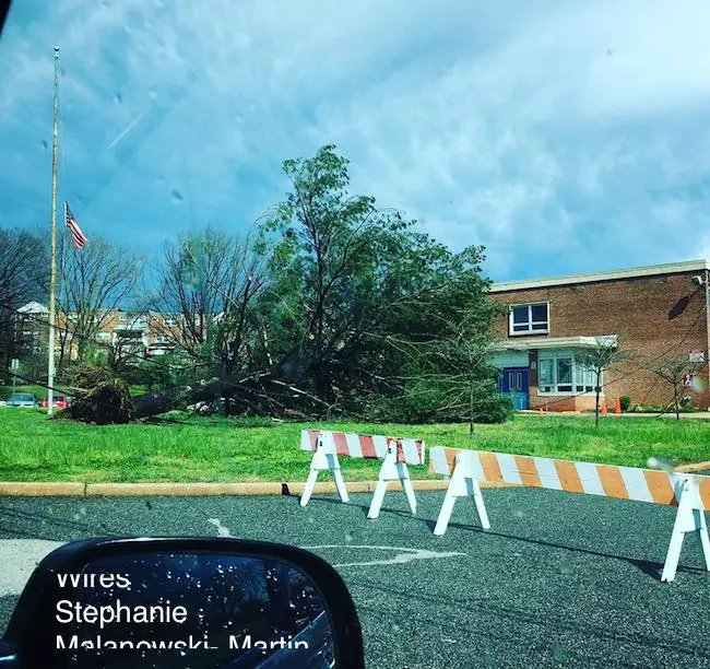
Wind Damage
—> slider
Mitchellville Maryland outside of Bowie? Two barns on family farm destroyed as reported by Justin Harvard
[metaslider id=46382]
Washington DC- Severe Storm criteria has winds over 58 mph. It looks like that was easily achieved to push down these trees.
There is a truck under this tree… according to Christina
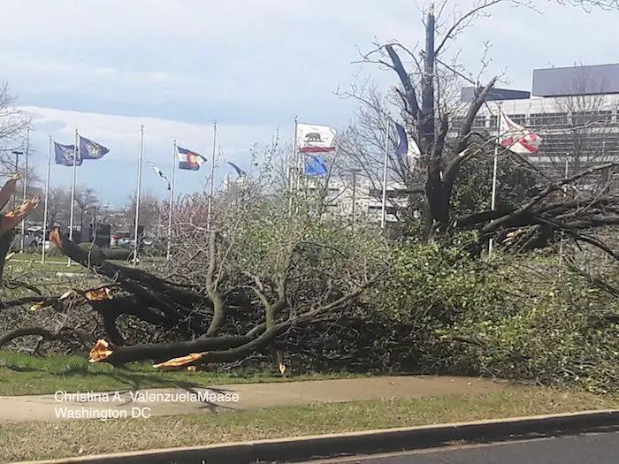
Gonzaga high school in DC from Dave Taylor

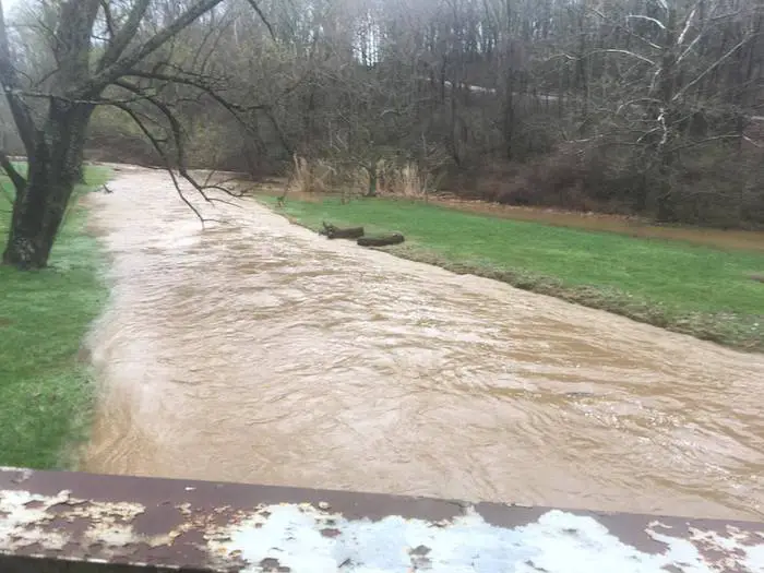
Heavy Rain
Over 2 inches of rain along the Maryland and Pennsylvania border into York County. This is the Stewartstown Bridge from Scott Stevenson
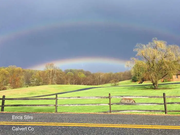
Double Rainbow
Calvert County after the first wave of storms
Maria from Rockville captured this rainbow after seeing the mammals clouds shown above.

Storm Smart: My STEM Assembly Program
Click here to see the details and how this educational program is also a fundraiser for schools. We can start scheduling for May now.

Wind Damage Reports For Our Region
| Time | 61 | Location | Town | State | Report | ||
| 1630 | 61 | POINT LOOKOUT | ANZ537 | MD | 3804 | 7632 | (LWX) |
| 1633 | UNK | THORNHILL | ORANGE | VA | 3815 | 7797 | MULTIPLE TREES MORE THAN 1 FT IN DIAMETER DOWN. STRUCTURAL DAMAGE FROM WIND AND A BARN WAS BLOWN DOWN (LWX) |
| 1640 | UNK | GREENCASTLE | FRANKLIN | PA | 3979 | 7773 | TREES/WIRES DOWN IN ANTRIM TWP/WILLIAMSON AVE AREA. ALSO REPORTED BY SPOTTER/PRINT MEDIA (CTP) |
| 1643 | UNK | 1 NE SOUTH NORFOLK | CITY OF CHESAPEAK | VA | 3681 | 7627 | TREES AND POWER LINES DOWN AT RICHMOND AND JACKSON AVE. (AKQ) |
| 1645 | UNK | 1 SW GWYNN | MATHEWS | VA | 3750 | 7630 | TREES AND POWER LINES DOWN ALONG RISBY TOWN RD ON GWYNN ISLAND. (AKQ) |
| 1645 | UNK | RICHARDSVILLE | CULPEPER | VA | 3840 | 7773 | TREES DOWN ON POWER LINES IN RICHARDSVILLE. (LWX) |
| 1650 | UNK | REMINGTON | FAUQUIER | VA | 3853 | 7781 | TREES DOWN IN REMINGTON. (LWX) |
| 1709 | UNK | 3 SSE GREENWICH | FAUQUIER | VA | 3871 | 7764 | DOZENS OF TREES DOWN. (LWX) |
| 1710 | UNK | 2 SSE HICKORY | CITY OF CHESAPEAK | VA | 3663 | 7621 | NUMEROUS TREES AND LINES DOWN IN THE HICKORY AREA ALONG SOUTH BATTLEFIELD … DELIA RD … HEAD OF RIVER AND EHTERIDGE. (AKQ) |
| 1710 | UNK | KING GEORGE | KING GEORGE | VA | 3827 | 7718 | TREES DOWN IN KING GEORGE ALONG 301. ONE INTO HOUSE. (LWX) |
| 1714 | UNK | 3 WSW BULL RUN | PRINCE WILLIAM | VA | 3876 | 7757 | TREES DOWN OFF SUDLEY MANOR ROAD. (LWX) |
| 1715 | 59 | INDEPENDENT HILL | PRINCE WILLIAM | VA | 3863 | 7744 | (LWX) |
| 1721 | 59 | 1 E MANASSAS | CITY OF MANASSAS | VA | 3875 | 7746 | (LWX) |
| 1724 | UNK | 1 WSW FAIRFAX STATION | FAIRFAX | VA | 3880 | 7734 | LARGE TREE DOWN BLOCKING PART OF SOUTHBOUND FAIRFAX COUNTY PARKWAY NEAR INTERSECTION OF BURKE CENTER PARKWAY (LWX) |
| 1727 | UNK | 2 SSE ARCOLA | LOUDOUN | VA | 3892 | 7752 | TREE ON CAR. (LWX) |
| 1738 | UNK | 1 S CHERRYDALE | ARLINGTON | VA | 3889 | 7711 | SEVERAL TREES AND POWER POLES SNAPPED. (LWX) |
| 1740 | UNK | 1 SSW THE MALL | DISTRICT OF COLUM | DC | 3888 | 7703 | TREES SNAPPED NEAR TIDAL BASIN. (LWX) |
| 1800 | UNK | 2 N BOWIE | PRINCE GEORGES | MD | 3898 | 7674 | TREES DOWN. (LWX) |
| 1805 | 59 | 1 S BOWIE | PRINCE GEORGES | MD | 3894 | 7674 | (LWX) |
| 1811 | UNK | 1 E STERLING PARK | LOUDOUN | VA | 3900 | 7739 | TREE UPROOTED … SIDING MISSING (LWX) |
| 1826 | 61 | 4 ESE CAPE ST. CLAIRE | ANZ531 | MD | 3902 | 7638 | (LWX) |
| 1830 | UNK | PIMLICO | BALTIMORE CITY | MD | 3936 | 7668 | ROOF BLOWN OFF OF APARTMENT BUILDING. (LWX) |
| 1832 | 58 | 1 N BALT-WASH INTL ARPT | ANNE ARUNDEL | MD | 3918 | 7667 | (LWX) |
| 1840 | 66 | 1 ENE WHITE MARSH | BALTIMORE | MD | 3939 | 7644 | (LWX) |
| 1844 | UNK | 1 NNW EDGEWOOD | HARFORD | MD | 3944 | 7631 | TREES DOWN ON ROUTE 24 BETWEEN 7 AND EDGEWOOD ROAD. (LWX) |
| 1850 | 62 | 3 ESE CHASE | ANZ531 | MD | 3936 | 7632 | (LWX) |
| 1852 | UNK | 2 WNW HAVRE DE GRACE | HARFORD | MD | 3956 | 7613 | TREE LIMBS DOWN IN THE 2000 BLOCK OF LEVEL ROAD. (LWX) |
| 1858 | 58 | OCEAN CITY | CAPE MAY | NJ | 3927 | 7460 | (PHI) |
| 1904 | 60 | 4 W SASSAFRAS | CECIL | MD | 3937 | 7588 | (PHI) |
| 1905 | 67 | 6 ESE HAVRE DE GRACE | ANZ530 | MD | 3951 | 7599 | (LWX) |
| 1910 | UNK | ELKTON | CECIL | MD | 3960 | 7582 | TREES AND WIRES REPORTED DOWN IN THE ELKTON AREA. (PHI) |
 Get the award winning Kid Weather App I made with my oldest son and support our love for science, weather, and technology. Our 3 year anniversary of the release and our contribution to STEM education is this November. It has been downloaded in 60 countries, and works in both temperature scales. With your support we can expand on the fun introduction to science and real weather.
Please share your thoughts, best weather pics/video, or just keep in touch via social media
-
Facebook: Justin Berk, Meteorologist
-
Twitter: @JustinWeather
-
Instagram: justinweather
Faith in the Flakes
The store is closing for the season. Next week we wil be shifting back to spring mode. This will include a severe weather STEM assembly program.
-
Sign up for email updates on new posts
Since you may miss some posts via social media, click here for email alerts as a way to make sure you don’t miss any. *You may have to refresh that page once for your browser to clear out the images.
Also See:
Extreme Weather of 2015 balanced out on both ends