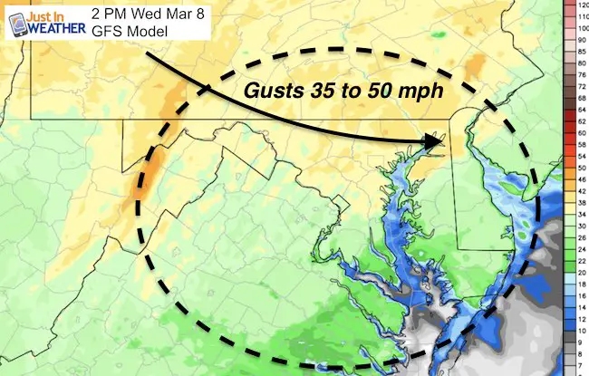
 Wednesday March 8 – Showers were slow to depart this morning, but the winds lived up to their expectation. BWI recorded a 45 mph wind gust at 4 AM, with some places gusting to 50 mph. This left some damage behind overnight. The warm air is still with us and the strong winds will return. The next phase of this outlook will be the the transition to cold air. A band of snow will arrive Friday, but most likely not be cold enough for srtickage, unless near the PA line and north. As for the other storm, and maybe another behind that? Here is where the irony shows up… I will show you computer models and then say that I don’t trust them. I have good reason not to I have more below. Still, we need to watch closely for this weekend and into next week.
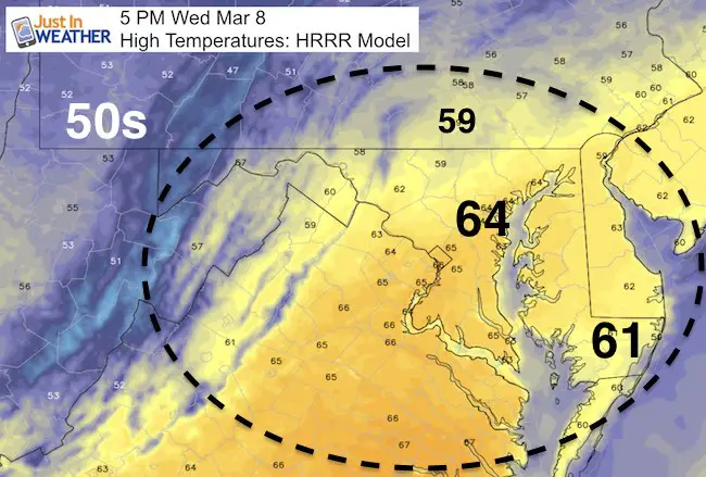
Still Warm Today
Next Wind Surge Later Today And Tonight
—> slider HRRR Model
Tracking The Snow
It will snow. The atmosphere is primed to produce it. The questions are about the intensity of the storms and the tracking of them. At this point the computer model guidance is just that… a guide, but NOT gospel. There has been too many errors this winter, so why trust them to lock in on these events now? If anything I see two points to focus on now:
- The bias all winter has been for storms to very father north. Friday’s snow is a little north of where it was the past two days. So the Sunday event is likely to trend back north as well… I think the lack of blocking to our north is the missing element, so the models are giving the cold air too much credit with the tracks below….
- The outlook now goes beyond the Sunday southern storm and gives the Canadian solution credit with a coastal storm Tuesday. That one shows more snow… I don’t see this as the final solution but does provide another chance in this active pattern.
Part 1 of 3
Snow will drift down from the north but likely not get much to stick in central Maryland. Maybe some near and north of the PA line.
[metaslider id=44039]
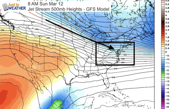
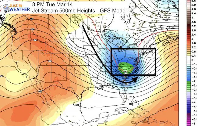
Jet Stream:
The upper air flow supports the winter pattern, but the surface reflection is not lining up as well… The trough of cold air not week does lead credit to a coastal storm…
Tracking The Snow Part 2 of 3
[metaslider id=44044]
Tracking The Snow Part 3 of 3
[metaslider id=44049]
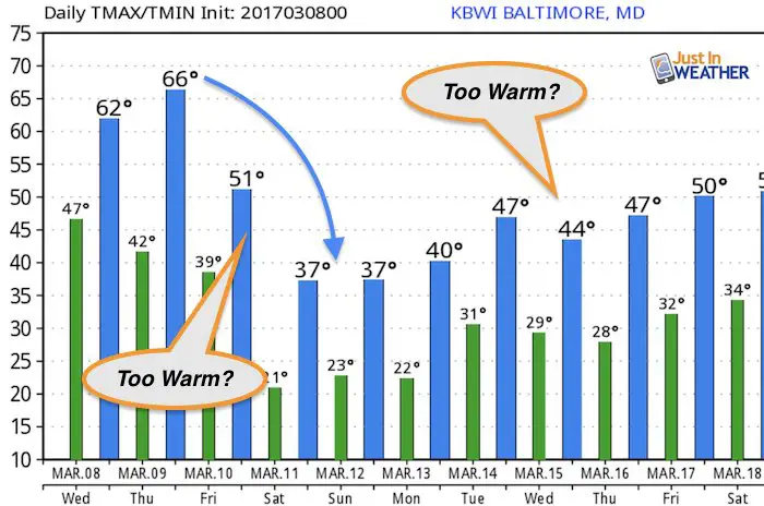
Temperature Outlook
Please keep posted and understand that I am sharing what I see and not wanting to push any single event. In fact, I am cautious about long range forecast storms this winter yet I think we need to keep track of the potential.
 Get the award winning Kid Weather App I made with my oldest son and support our love for science, weather, and technology. Our 3 year anniversary of the release and our contribution to STEM education is this November. It has been downloaded in 60 countries, and works in both temperature scales. With your support we can expand on the fun introduction to science and real weather.
Please share your thoughts, best weather pics/video, or just keep in touch via social media
-
Facebook: Justin Berk, Meteorologist
-
Twitter: @JustinWeather
-
Instagram: justinweather
Faith in the Flakes Online- Flannel PJs Printed Inside Out
Store Now Open

- We’ve added Flannel PJ Pants that will be printed inside out. They have to be, to make it snow ?
- Free Personal Delivery for orders of 20 items or more to schools and businesses.
- Click this image for the online store.
- Look for more items to be added soon.
- Also see the info for the STEM Assembly Spirit Wear program: Put your school name on the shirts and raise money for you PTO/PTA in the process.
Sign up for email updates on new posts
Since you may miss some posts via social media, click here for email alerts as a way to make sure you don’t miss any. *You may have to refresh that page once for your browser to clear out the images.
FITF SNOW STICKS
 Available in 2 Ft, 30 Inches, and 3 Ft Sizes. Also with Orange/Black or Purple/Black. Click on the image to see the options offered by my friend Thatcher at Signs By Tomorrow in Timonium.
Go to http://www.signsbytomorrow.com/timonium/ to order yours today! Click the ‘Request a Quote’ button at the top of the page. In comment box include color, size and payment information. Please indicate whether you’d like to have us UPS ship them to you or if you would like to pick up in our store. Snow Sticks will ship or will be ready for pick up in our store 48 hrs after order is placed, Mon-Fri.
Also See:
My Winter Outlook for 2016-2017: Colder with snow spread out more
NOAA Winter Outlook for 2016 to 2017
La Nina Formed: What it could mean to our winter
Farmers Almanacs Split On Cold And Snow
Extreme Weather of 2015 balanced out on both ends
Low Snow Winters In Baltimore: Records Might Surprise You
Faith in the Flowers
In a few weeks my friend Lexi Hack and I will be bringing back these shirts and the fundraiser for Save a Limb Fund at Sinai Hospital. Also stay tuned for my new Storm Smart Assembly program. A STEM based assembly on severe weather for elementary and middle schools.