March 8 2017 – It is going to snow! I felt like I need to state that because we are tied for the lowest seasonal winter snowfall in Baltimore, it is still in the 60s, and it is March…. So this might be hard to believe. But it really will snow as the pattern will change to the most weather action we have had all winter. FITF The two questions that follow is how much and will it stick? Well, lets start with the first event that has the most confidence… Friday. I know this winter seems like the fisherman in the Geico Commercial. But we really have a few more chances that will follow.

Friday Snow
This first snow will be the mark of the arctic air moving into our region. That work arctic is important as I’ve pointed out over the past few days the jet stream changing thanks to a storm near the Arctic Circle in northern Canada. The first wave will bring snow but I personally think the ground and marginal air temps will be too warm for much to stick. School should be on time. But Pennsylvania will get more stickage…
—> slider GFS Model
Snowfall Maps
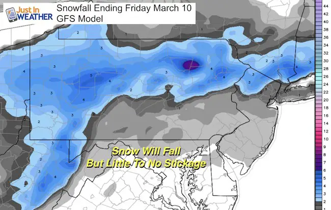
Can we get 1 inch of snow? Sure! But stickage will be a problem, especially after 10 AM when the sun angle is higher.
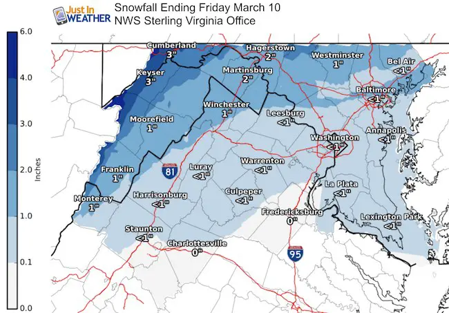
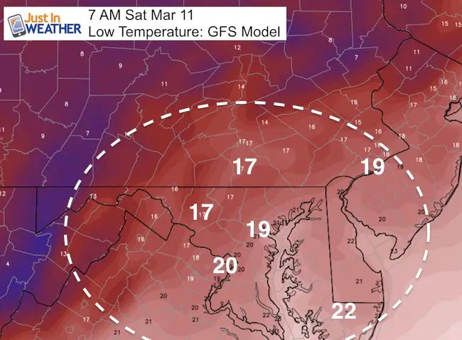
Notice the State College NWS Office has less snow in southern PA along the boarder than the Sterling NWS Office has.
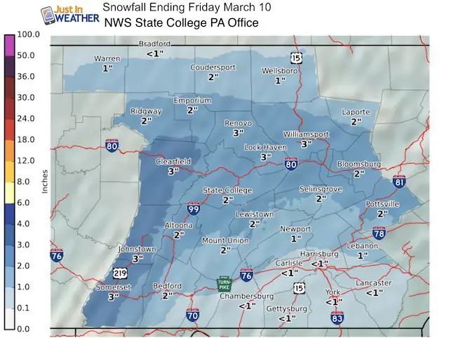
Behind this storm will be an arctic air mass we would normally see in January. The forecast low temps area reflection of how far south it can penetrate, especially with little snowpack to our north.
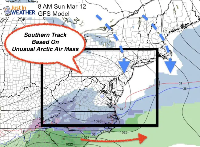
Sunday Storm Staying South?
This will be one benchmark to focus on before the Sunday storm. It is the depth of this air mass that is the reason that storm has been projected to be suppressed. I still think the modeling error has this too strong… so the Southern storm track should verify farther north and still close enough to pay attention to. This is the same model that had a direct hit for us a few days ago… I will keep pointing out the northern edge for any shift back.
What may follow is what the jet stream showed last night… and what the Canadian Model showed two days ago. I showed it in this prior post and brushed it aside as the outlier. It may have led the charge since the GFS and European Models are in agreement on a coastal storm Tuesday. This phases the northern and southern branches of the jet stream with the tender transition zone over Maryland. This is always delicate as that bubble can also be a dry slot if the timing is off.
Coastal Next Week?
—> slider GFS Model
I have to show that… but also add the disclaimer that the models have been that Geico Fisherman all winter. Why would it be any different now? Well, if we truly get this northern branch of the jet stream to take over, that would be better for the modeling. This winter has a strong Pacific Jet and that has been the trouble. So different pattern would be a good thing…
[metaslider id=44074]
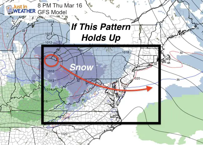
If this is the case and the northern branch of the jet takes over, then there is more credence to it holding firm and bringing in yet another potential clipper type system to follow.
 Get the award winning Kid Weather App I made with my oldest son and support our love for science, weather, and technology. Our 3 year anniversary of the release and our contribution to STEM education is this November. It has been downloaded in 60 countries, and works in both temperature scales. With your support we can expand on the fun introduction to science and real weather.
Please share your thoughts, best weather pics/video, or just keep in touch via social media
-
Facebook: Justin Berk, Meteorologist
-
Twitter: @JustinWeather
-
Instagram: justinweather
Faith in the Flakes Online- Flannel PJs Printed Inside Out
Store Now Open

- We’ve added Flannel PJ Pants that will be printed inside out. They have to be, to make it snow ?
- Free Personal Delivery for orders of 20 items or more to schools and businesses.
- Click this image for the online store.
- Look for more items to be added soon.
- Also see the info for the STEM Assembly Spirit Wear program: Put your school name on the shirts and raise money for you PTO/PTA in the process.
Sign up for email updates on new posts
Since you may miss some posts via social media, click here for email alerts as a way to make sure you don’t miss any. *You may have to refresh that page once for your browser to clear out the images.
FITF SNOW STICKS
 Available in 2 Ft, 30 Inches, and 3 Ft Sizes. Also with Orange/Black or Purple/Black. Click on the image to see the options offered by my friend Thatcher at Signs By Tomorrow in Timonium.
Go to http://www.signsbytomorrow.com/timonium/ to order yours today! Click the ‘Request a Quote’ button at the top of the page. In comment box include color, size and payment information. Please indicate whether you’d like to have us UPS ship them to you or if you would like to pick up in our store. Snow Sticks will ship or will be ready for pick up in our store 48 hrs after order is placed, Mon-Fri.
Also See:
My Winter Outlook for 2016-2017: Colder with snow spread out more
NOAA Winter Outlook for 2016 to 2017
La Nina Formed: What it could mean to our winter
Farmers Almanacs Split On Cold And Snow
Extreme Weather of 2015 balanced out on both ends
Low Snow Winters In Baltimore: Records Might Surprise You
Faith in the Flowers
In a few weeks my friend Lexi Hack and I will be bringing back these shirts and the fundraiser for Save a Limb Fund at Sinai Hospital. Also stay tuned for my new Storm Smart Assembly program. A STEM based assembly on severe weather for elementary and middle schools.