Friday Evening Jan 13 – The only main update this evening is that the Winter Weather Advisory in southern Pennsylvania has been expanded from 7 AM until midnight. This is in response the the signals that this system is behaving as I suggested earlier, and will verify a little farther north that first suggested. So once again the icing and issues will linger on the north end. Metro Baltimore will have snow or an icy mix developing in the morning, then be marginal or rise just above freezing lunch time into afternoon.
That is important in central Maryland and DC because I believe warmer air will push in farther from the south as well. So driving will not be too much of a problem mid day between Washington and Annapolis and the Eastern Shore.
Columbia and Mount Airy will be on the edge of the thaw then. The exception will be that this cold air hangs north and northeast. This includes northern Carrol, Baltimore, Harford, and Cecil Counties.
Snow should be most evident around noon between Baltimore, York, Bel Air, and Cecil County. Then gradual warming pushes north. The latest radar simulation does appear to be holding close to the arrival timeline I showed this morning. I posting that below the slider for reference.
Snow totals will be minimal as well as icing, but the typical northern counties of Maryland and southern Pennsylvania will have the concern mid day and afternoon. You will see the snow reaching Cecil County and northern Delaware, but their local NWS Office has not issued any advisories at this time.
Radar Simulation —> slider HRRR Model
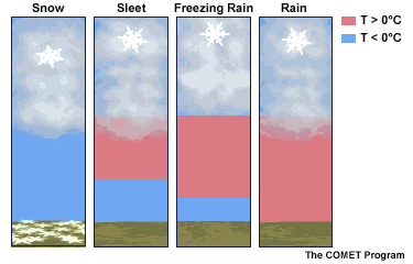
Click to see more about wintry precipitation
Arrival Timeline: Close to what I posted this morning


Recent Posts
Winter Weather Advisory Saturday January 14
Call For Snowfall Jan 14
Record High At BWI: Baltimore Goes From 70F To Snow
Faith in the Flakes Online- Flannel PJs Printed Inside Out
Store Now Open

- We’ve added Flannel PJ Pants that will be printed inside out. They have to be, to make it snow ?
- Free Personal Delivery for orders of 20 items or more to schools and businesses.
- Click this image for the online store.
- Look for more items to be added soon.
- Also see the info for the STEM Assembly Spirit Wear program: Put your school name on the shirts and raise money for you PTO/PTA in the process.
FITF SNOW STICKS
 Available in 2 Ft, 30 Inches, and 3 Ft Sizes. Also with Orange/Black or Purple/Black. Click on the image to see the options offered by my friend Thatcher at Signs By Tomorrow in Timonium.
Go to http://www.signsbytomorrow.com/timonium/ to order yours today! Click the ‘Request a Quote’ button at the top of the page. In comment box include color, size and payment information. Please indicate whether you’d like to have us UPS ship them to you or if you would like to pick up in our store. Snow Sticks will ship or will be ready for pick up in our store 48 hrs after order is placed, Mon-Fri.
Please share your thoughts, best weather pics/video, or just keep in touch via social media
- Facebook: Justin Berk, Meteorologist
- Twitter: @JustinWeather
- Instagram: justinweather
 Get the award winning Kid Weather App I made with my oldest son and support our love for science, weather, and technology. Our 3 year anniversary of the release and our contribution to STEM education is this November. It has been downloaded in 60 countries, and works in both temperature scales. With your support we can expand on the fun introduction to science and real weather.
Sign up for email updates on new posts
Since you may miss some posts via social media, click here for email alerts as a way to make sure you don’t miss any. *You may have to refresh that page once for your browser to clear out the images.
Also See:
My Winter Outlook for 2016-2017: Colder with snow spread out more
NOAA Winter Outlook for 2016 to 2017
La Nina Formed: What it could mean to our winter
Farmers Almanacs Split On Cold And Snow
Extreme Weather of 2015 balanced out on both ends
Low Snow Winters In Baltimore: Records Might Surprise You
NOAA Ranks Blizzard 2016 4th Worst Snowstorm On Record
Blizzard 2016 Record Top Snowstorm: Area Totals