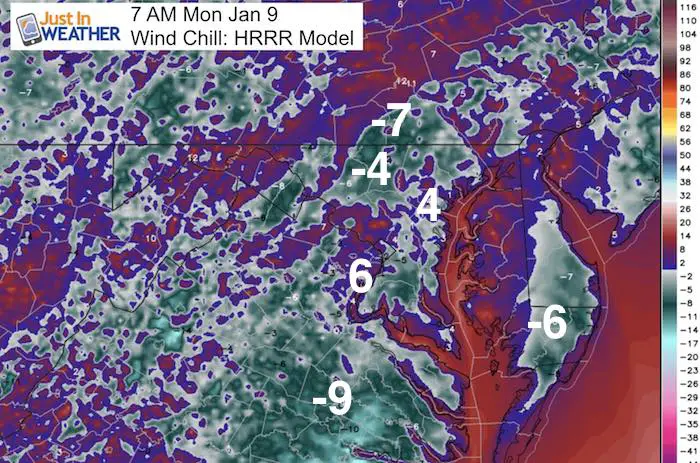
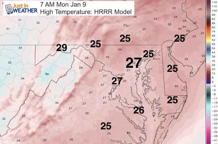
 Monday January 9 – This morning is frigid. No two ways about it. Temps in the lower teens for most and wind chills below zero. Not much of a warm up, even in southern Maryland to the beaches thanks to deep snowpack. Many schools on Maryland’s lower Eastern Shore are closed today due to Saturday storm. Notice the uniform temps staying in the mid 20s. There will be quite a warm up this week with 60°F by Thursday and Friday! But that does not mean winter is over, by far! However the active jet stream will be producing a few ‘events’ that we need to track. The first one on Tuesday I think will skirt the north side of our region, the second one this weekend could be more of an ice maker. I do want to point out what helped me forecast the last snow storm… there is a trend for storms to verify farther north. So where we see ice setting up next weekend could shift. Let’s take a look:
Afternoon Highs Today
Tuesday Snow/Ice North: —> slider GFS Model
As the warmer air arrives with the next storm, there will be a band of snow and ice arriving. The timing appears to be mid day or afternoon Tuesday. That is not the worst thing as daytime heating wil limit the impact on roads… So timing is key… earlier in the day would be a problem. But the track is also important, and for now it looks like the first flakes or ice pellets will be passing northwest of Baltimore. Should there be anything in central Maryland, it would be very light. If you want a school delay or concerned about travel, the best bet would be freezing drizzle that models have trouble picking up on. I will track this in more detail in this afternoon’s report.
Cold Front
The cold air will try to make a brief return Friday behind the next storm. The location of this will be an important set up for the next storm to follow over the weekend.

Weekend Event
Ice for our region will be termed by how far south the cold front will reach as well asa the strength of that High Pressure center in eastern Canada.
Note the recent model bias for storms verifying farther north. If that holds, this will be more of an issue for central PA. So that trend is worth watching.
[metaslider id=42267]
Jet Stream —> slider
Warm up aloft will mean much of the next two weeks will be warmer than average… but colder air will build up and return. There is plenty of winter left.
[metaslider id=42274]Temperature Outlook

Faith in the Flakes Online- Flannel PJs Printed Inside Out
Store Now Open

- We’ve added Flannel PJ Pants that will be printed inside out. They have to be, to make it snow ?
- Free Personal Delivery for orders of 20 items or more to schools and businesses.
- Click this image for the online store.
- Look for more items to be added soon.
- Also see the info for the STEM Assembly Spirit Wear program: Put your school name on the shirts and raise money for you PTO/PTA in the process.
FITF SNOW STICKS
 Available in 2 Ft, 30 Inches, and 3 Ft Sizes. Also with Orange/Black or Purple/Black. Click on the image to see the options offered by my friend Thatcher at Signs By Tomorrow in Timonium.
Go to http://www.signsbytomorrow.com/timonium/ to order yours today! Click the ‘Request a Quote’ button at the top of the page. In comment box include color, size and payment information. Please indicate whether you’d like to have us UPS ship them to you or if you would like to pick up in our store. Snow Sticks will ship or will be ready for pick up in our store 48 hrs after order is placed, Mon-Fri.
Please share your thoughts, best weather pics/video, or just keep in touch via social media
- Facebook: Justin Berk, Meteorologist
- Twitter: @JustinWeather
- Instagram: justinweather
 Get the award winning Kid Weather App I made with my oldest son and support our love for science, weather, and technology. Our 3 year anniversary of the release and our contribution to STEM education is this November. It has been downloaded in 60 countries, and works in both temperature scales. With your support we can expand on the fun introduction to science and real weather.
Sign up for email updates on new posts
Since you may miss some posts via social media, click here for email alerts as a way to make sure you don’t miss any. *You may have to refresh that page once for your browser to clear out the images.
Also See:
My Winter Outlook for 2016-2017: Colder with snow spread out more
NOAA Winter Outlook for 2016 to 2017
La Nina Formed: What it could mean to our winter
Farmers Almanacs Split On Cold And Snow
Extreme Weather of 2015 balanced out on both ends
Low Snow Winters In Baltimore: Records Might Surprise You