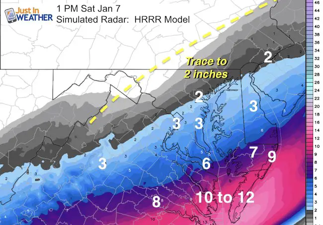
 Friday Night Update Jan 6 – The shirt of the storm expectation to the north we have been talking about for a few days is now getting validation as it is about to arrive. A Winter Weather Advisory has now been extended to northern Maryland, including Baltimore, southern Harford and Cecil Counties. This area is on the northern edge of the storm that will receive 1 to 3 inches of snow. This may reach farther north to the PA line. Meanwhile parts of the Delmarva will get between 6 and 12 inches. Temps in the low 20s will mean a fluffy snow, maximum stickage, and a fluff factor. I am sorry for the late post, but family agenda and consulting with my clients slowed my report down. Now I get to show you the details. Note: This will be a southern storm with 6 inches or more for Salisbury and Ocean City. But I still think there wil be snow extending farther north. Below are my timeline and snowfall map, along with the radar simulation. But first:
Here is the Water Vapor Satellite Loop. I’ve highlighted a signature I look for called a baroclinic leaf. It is a mark of moisture often showing up on the northwest edge of the potential snow edge a day before a storm arrives. This is the weakness in the atmosphere being plowed ahead of the storm to follow.
Watch the loop below to see the flow of the moisture and see the northwest push along the east coast. This is the timing issue I mentioned earlier this week. The storm energy will arrive before the jet can drop too far south and let the storm reach us.
Click here to see The Saturday Morning Update

Water Vapor Satellite Loop
Snow Arrival Timeline

Radar Simulation —> slider HRRR Model
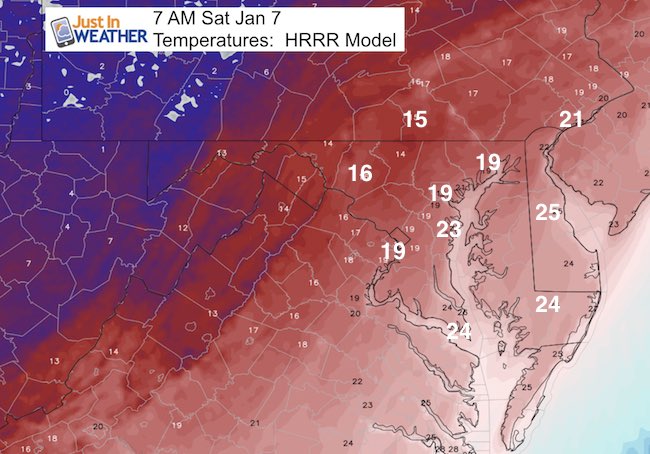
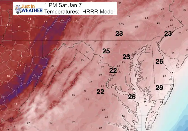
Temperatures:
Morning
Afternoon
Snowfall Expectation From HRRR
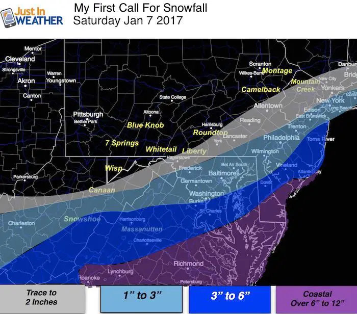
My Call For Snowfall
This includes the northward projection of the edge of the snow. There will be a high fluff factor due to low temperatures.
Faith in the Beach Flakes
Faith in the Flakes Online- Flannel PJs Printed Inside Out
Store Now Open

- We’ve added Flannel PJ Pants that will be printed inside out. They have to be, to make it snow ?
- Free Personal Delivery for orders of 20 items or more to schools and businesses.
- Click this image for the online store.
- Look for more items to be added soon.
- Also see the info for the STEM Assembly Spirit Wear program: Put your school name on the shirts and raise money for you PTO/PTA in the process.
FITF SNOW STICKS
 Available in 2 Ft, 30 Inches, and 3 Ft Sizes. Also with Orange/Black or Purple/Black. Click on the image to see the options offered by my friend Thatcher at Signs By Tomorrow in Timonium.
Go to http://www.signsbytomorrow.com/timonium/ to order yours today! Click the ‘Request a Quote’ button at the top of the page. In comment box include color, size and payment information. Please indicate whether you’d like to have us UPS ship them to you or if you would like to pick up in our store. Snow Sticks will ship or will be ready for pick up in our store 48 hrs after order is placed, Mon-Fri.
Please share your thoughts, best weather pics/video, or just keep in touch via social media
- Facebook: Justin Berk, Meteorologist
- Twitter: @JustinWeather
- Instagram: justinweather
 Get the award winning Kid Weather App I made with my oldest son and support our love for science, weather, and technology. Our 3 year anniversary of the release and our contribution to STEM education is this November. It has been downloaded in 60 countries, and works in both temperature scales. With your support we can expand on the fun introduction to science and real weather.
Sign up for email updates on new posts
Since you may miss some posts via social media, click here for email alerts as a way to make sure you don’t miss any. *You may have to refresh that page once for your browser to clear out the images.
Also See:
My Winter Outlook for 2016-2017: Colder with snow spread out more
NOAA Winter Outlook for 2016 to 2017
La Nina Formed: What it could mean to our winter
Farmers Almanacs Split On Cold And Snow
Extreme Weather of 2015 balanced out on both ends
Low Snow Winters In Baltimore: Records Might Surprise You